चित्र:Australian external territories.png
इससे बड़ा रेसोल्यूशन उपलब्ध नहीं हैं।
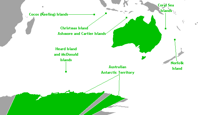
Australian_external_territories.png ((644 × 376 पिक्सेल, फ़ाइल का आकार: 14 KB, MIME प्रकार: image/png))
|
|
यह फ़ाइल विकिमेडिया कॉमन्स से है। वहाँ पर इसका विवरण पृष्ठ निम्नोक्त है। कॉमन्स मुक्त लाइसेंसों के अंतर्गत उपलब्ध मीडिया फ़ाइलों का संग्रह है। आप भी इसमें मदद कर सकते हैं। |

|
This locator map image could be re-created using vector graphics as an SVG file. This has several advantages; see Commons:Media for cleanup for more information. If an SVG form of this image is available, please upload it and afterwards replace this template with
{{vector version available|new image name}}.
It is recommended to name the SVG file “Australian external territories.svg”—then the template Vector version available (or Vva) does not need the new image name parameter. |
सारांश
This is a map of Australia's external territories. The base map is Image:Antarctica territorial claims.png by User:Astrokey44 since it shows the AAT. The location of the other territories is Image:BlankMap-World-v6.png by the same user. The previous maps are under the GFDL; therefore, this map is too.
लाइसेंस
मैं, इस कार्य का/की कॉपीराइट धारक, इसे निम्न लाइसेंसों के अंतर्गत प्रकाशित करता/करती हूँ:

|
इस दस्तावेज़ को Free Software Foundation द्वारा प्रकाशित GNU मुक्त प्रलेख लाइसेंस के संस्करण 1.2 या नए (बिना किसी अपरिवर्तनीय अनुभागों और अगले या पिछले आवरण के टेक्स्ट के) के अंतर्गत प्रतिलिपि बनाने, बाँटने और/या बदलने की अनुमति प्रदान की जाती है। इस लाइसेंस की एक प्रतिलिपि GNU मुक्त प्रलेख लाइसेंस नामक अनुभाग में शामिल है। |
| इस फ़ाइल को क्रिएटिव कॉमन्स श्रेय-समानसांझा 3.0 अनरिपोर्टेड लाइसेंस के अंतर्गत लाइसेंस किया गया है। | ||
| ||
| This licensing tag was added to this file as part of the GFDL licensing update. |
आप अपना पसंद का लाइसेंस चुन सकते हैं।
चित्र का इतिहास
फ़ाइलका पुराना अवतरण देखने के लिये दिनांक/समय पर क्लिक करें।
| दिनांक/समय | थंबनेल | आकार | सदस्य | प्रतिक्रिया | |
|---|---|---|---|---|---|
| वर्तमान | 06:40, 18 नवम्बर 2010 | | 644 × 376 (14 KB) | Hoshie | rm boundary lines in Africa, SE Asia, and PNG to focus on Australia and its territories; fixed color of the Comoros |
| 10:00, 17 मार्च 2007 |  | 644 × 376 (14 KB) | Hoshie | This is a map of Australia's external territories. The base map is Image:Antarctica territorial claims.png by User:Astrokey44 since it shows the AAT. The location of the other territories is Image:BlankMap-World-v6.png by the same user. The |
चित्र का उपयोग
निम्नलिखित पन्ने इस चित्र से जुडते हैं :
चित्र का वैश्विक उपयोग
इस चित्र का उपयोग इन दूसरे विकियों में किया जाता है:
- af.wikipedia.org पर उपयोग
- az.wikipedia.org पर उपयोग
- ba.wikipedia.org पर उपयोग
- be.wikipedia.org पर उपयोग
- br.wikipedia.org पर उपयोग
- bs.wikipedia.org पर उपयोग
- cs.wikipedia.org पर उपयोग
- de.wikipedia.org पर उपयोग
- en.wikipedia.org पर उपयोग
- eo.wikipedia.org पर उपयोग
- gl.wikipedia.org पर उपयोग
- hy.wikipedia.org पर उपयोग
- incubator.wikimedia.org पर उपयोग
- ka.wikipedia.org पर उपयोग
- ko.wikipedia.org पर उपयोग
- lv.wikipedia.org पर उपयोग
- mr.wikipedia.org पर उपयोग
- oc.wikipedia.org पर उपयोग
- pa.wikipedia.org पर उपयोग
- ru.wikipedia.org पर उपयोग
- ru.wikinews.org पर उपयोग
- sh.wikipedia.org पर उपयोग
- simple.wikipedia.org पर उपयोग
- sk.wikipedia.org पर उपयोग
- sr.wikipedia.org पर उपयोग
- ta.wikipedia.org पर उपयोग
- th.wikipedia.org पर उपयोग
- tr.wikipedia.org पर उपयोग
- vec.wikipedia.org पर उपयोग
- war.wikipedia.org पर उपयोग
- xmf.wikipedia.org पर उपयोग
- zh.wikipedia.org पर उपयोग