चित्र:Location of the Ryukyu Islands.JPG
इस पूर्वावलोकन का आकार: 654 × 599 पिक्सेल। दूसरे रेसोल्यूशन्स: 262 × 240 पिक्सेल | 524 × 480 पिक्सेल।
मूल चित्र ((800 × 733 पिक्सेल, फ़ाइल का आकार: 310 KB, MIME प्रकार: image/jpeg))
|
|
यह फ़ाइल विकिमेडिया कॉमन्स से है। वहाँ पर इसका विवरण पृष्ठ निम्नोक्त है। कॉमन्स मुक्त लाइसेंसों के अंतर्गत उपलब्ध मीडिया फ़ाइलों का संग्रह है। आप भी इसमें मदद कर सकते हैं। |

|
This locator map image could be re-created using vector graphics as an SVG file. This has several advantages; see Commons:Media for cleanup for more information. If an SVG form of this image is available, please upload it and afterwards replace this template with
{{vector version available|new image name}}.
It is recommended to name the SVG file “Location of the Ryukyu Islands.svg”—then the template Vector version available (or Vva) does not need the new image name parameter. |


सारांश
| विवरण |
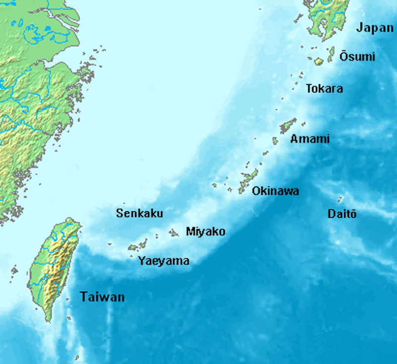
English: Location map of the Ryukyu islands (Nansei islands). This is a modification of the:
http://commons.wikimedia.org/wiki/Image:Location_Ryukyu_Islands.PNG |
| दिनांक | June 2006 |
| स्रोत | अपना कार्य |
| लेखक | Uchinanchu |
| दूसरे संस्करण |
|

लाइसेंस

|
The copyright holder of this work allows anyone to use it for any purpose including unrestricted redistribution, commercial use, and modification.
Usage notes:
|
चित्र का इतिहास
फ़ाइलका पुराना अवतरण देखने के लिये दिनांक/समय पर क्लिक करें।
| दिनांक/समय | थंबनेल | आकार | सदस्य | प्रतिक्रिया | |
|---|---|---|---|---|---|
| वर्तमान | 16:43, 7 अगस्त 2019 | | 800 × 733 (310 KB) | Artanisen | Higher quality and larger version. |
| 05:24, 28 जून 2006 |  | 482 × 377 (47 KB) | Uchinanchu | Location of the Ryukyu Islands Modification of the: http://commons.wikimedia.org/wiki/Image:Location_Ryukyu_Islands.PNG |
चित्र का उपयोग
निम्नलिखित पन्ने इस चित्र से जुडते हैं :
चित्र का वैश्विक उपयोग
इस चित्र का उपयोग इन दूसरे विकियों में किया जाता है:
- af.wikipedia.org पर उपयोग
- ang.wikipedia.org पर उपयोग
- ar.wikipedia.org पर उपयोग
- ast.wikipedia.org पर उपयोग
- az.wikipedia.org पर उपयोग
- bg.wikipedia.org पर उपयोग
- bh.wikipedia.org पर उपयोग
- br.wikipedia.org पर उपयोग
- ca.wikipedia.org पर उपयोग
- cdo.wikipedia.org पर उपयोग
- da.wikipedia.org पर उपयोग
- de.wikipedia.org पर उपयोग
- Ryūkyū-Inseln
- Geschichte der Ryūkyū-Inseln
- Nansei-Inseln
- Kerama-Inseln
- Diploderma polygonatum
- Plestiodon kishinouyei
- Sinomicrurus japonicus
- Eigentliche Zwergschlangen
- Calamaria pfefferi
- Achalinus werneri
- Lycodon multifasciatus
- Ptyas herminae
- Hebius pryeri
- Hebius ishigakiensis
- Hebius concelarus
- Gekko vertebralis
- Ateuchosaurus pellopleurus
- Scincella boettgeri
- Plestiodon japonicus
- Plestiodon marginatus
- Plestiodon latiscutatus
- Plestiodon finitimus
- Plestiodon kuchinoshimensis
- Plestiodon stimpsonii
- Plestiodon takarai
- Plestiodon oshimensis
- Buergeria japonica
- Japanisch-taiwanische Beziehungen
- en.wikipedia.org पर उपयोग
इस चित्र के वैश्विक उपयोग की अधिक जानकारी देखें।