चित्र:South America southern tip pol.png

इस पूर्वावलोकन का आकार: 800 × 494 पिक्सेल। दूसरे रेसोल्यूशन्स: 320 × 198 पिक्सेल | 640 × 395 पिक्सेल | 1,024 × 632 पिक्सेल | 1,280 × 790 पिक्सेल | 2,560 × 1,581 पिक्सेल | 3,859 × 2,383 पिक्सेल।
मूल चित्र ((3,859 × 2,383 पिक्सेल, फ़ाइल का आकार: 596 KB, MIME प्रकार: image/png))
|
|
यह फ़ाइल विकिमेडिया कॉमन्स से है। वहाँ पर इसका विवरण पृष्ठ निम्नोक्त है। कॉमन्स मुक्त लाइसेंसों के अंतर्गत उपलब्ध मीडिया फ़ाइलों का संग्रह है। आप भी इसमें मदद कर सकते हैं। |
सारांश
| विवरण |
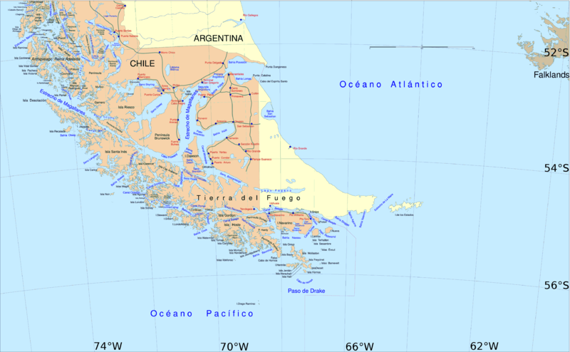
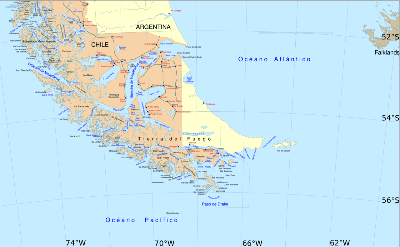
English: Political map of southern Chile and Argentina, from Straits of Magellan to Cape Horn.
Español: Mapa político del sur de Chile y la Argentina, entre el estrecho de Magallanes y el cabo de Hornos. |
||||
| दिनांक | |||||
| स्रोत | File:Sur2.gif | ||||
| लेखक | User:Createaccount | ||||
| अनुमति (इस चित्र का पुनः उपयोग करना) |
|
||||
| दूसरे संस्करण | Derivative works of this file: Metula.svg |
लाइसेंस

|
इस दस्तावेज़ को Free Software Foundation द्वारा प्रकाशित GNU मुक्त प्रलेख लाइसेंस के संस्करण 1.2 या नए (बिना किसी अपरिवर्तनीय अनुभागों और अगले या पिछले आवरण के टेक्स्ट के) के अंतर्गत प्रतिलिपि बनाने, बाँटने और/या बदलने की अनुमति प्रदान की जाती है। इस लाइसेंस की एक प्रतिलिपि GNU मुक्त प्रलेख लाइसेंस नामक अनुभाग में शामिल है। |
| इस फ़ाइल को क्रिएटिव कॉमन्स श्रेय-समानसांझा 3.0 अनरिपोर्टेड लाइसेंस के अंतर्गत लाइसेंस किया गया है। | ||
| ||
| This licensing tag was added to this file as part of the GFDL licensing update. |
चित्र का इतिहास
फ़ाइलका पुराना अवतरण देखने के लिये दिनांक/समय पर क्लिक करें।
| दिनांक/समय | थंबनेल | आकार | सदस्य | प्रतिक्रिया | |
|---|---|---|---|---|---|
| वर्तमान | 14:06, 30 अप्रैल 2016 | | 3,859 × 2,383 (596 KB) | Hohum | Cartographic colours |
| 11:09, 3 अप्रैल 2013 |  | 3,859 × 2,383 (597 KB) | Keysanger | Margin right and top cropped | |
| 10:47, 3 अप्रैल 2013 |  | 3,859 × 2,383 (597 KB) | Keysanger | "Estrecho Nelson" added Bigger Latitude and Longitude within the image empty margin cropped | |
| 19:30, 3 मई 2009 |  | 3,894 × 2,441 (639 KB) | Pitichinaccio | different colour | |
| 19:29, 3 मई 2009 |  | 3,894 × 2,441 (639 KB) | Pitichinaccio | {{Information |Description={{en|1=political map of southern Chile/Argentina: From Straits of Magellan to Cape Horn}} |Source=File:Sur2.gif |Author=User:Createaccount |Date=2008 |Permission={{GFDL-GMT}}} |other_versions=File:Sur2.gif }} <!-- |
चित्र का उपयोग
इस चित्र से कोई पन्ने नहीं जुड़ते
चित्र का वैश्विक उपयोग
इस चित्र का उपयोग इन दूसरे विकियों में किया जाता है:
- af.wikipedia.org पर उपयोग
- als.wikipedia.org पर उपयोग
- ar.wikipedia.org पर उपयोग
- ast.wikipedia.org पर उपयोग
- br.wikipedia.org पर उपयोग
- ca.wikipedia.org पर उपयोग
- de.wikipedia.org पर उपयोग
- de.wiktionary.org पर उपयोग
- el.wikipedia.org पर उपयोग
- en.wikipedia.org पर उपयोग
- Cape Froward
- Porvenir, Chile
- Santa Inés Island
- Puerto Toro
- False Cape Horn
- Puerto del Hambre
- Maritime history of California
- Brunswick Peninsula
- Almirantazgo Fjord
- Fjord of the Mountains
- Primera Angostura
- Aracena Island
- Punta Dúngeness
- Muñoz Gamero Peninsula
- Seno Otway
- Mitre Peninsula
- Marlborough (1876 ship)
इस चित्र के वैश्विक उपयोग की अधिक जानकारी देखें।