चित्र:Topografic map of Tibetan Plateau.png

इस पूर्वावलोकन का आकार: 800 × 429 पिक्सेल। दूसरे रेसोल्यूशन्स: 320 × 172 पिक्सेल | 640 × 343 पिक्सेल | 1,365 × 732 पिक्सेल।
मूल चित्र ((1,365 × 732 पिक्सेल, फ़ाइल का आकार: 663 KB, MIME प्रकार: image/png))
|
|
यह फ़ाइल विकिमेडिया कॉमन्स से है। वहाँ पर इसका विवरण पृष्ठ निम्नोक्त है। कॉमन्स मुक्त लाइसेंसों के अंतर्गत उपलब्ध मीडिया फ़ाइलों का संग्रह है। आप भी इसमें मदद कर सकते हैं। |
| विवरण |
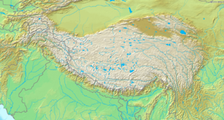
English: Topografic map of the Tibetan Plateau in Asia.
Français : Carte topographique du plateau tibetain.
|
||||
| दिनांक | अज्ञात तारीख | ||||
| स्रोत | http://www.demis.nl/home/pages/Gallery/examples.htm | ||||
| लेखक | अनजान | ||||
| अनुमति (इस चित्र का पुनः उपयोग करना) |
|
चित्र का इतिहास
फ़ाइलका पुराना अवतरण देखने के लिये दिनांक/समय पर क्लिक करें।
| दिनांक/समय | थंबनेल | आकार | सदस्य | प्रतिक्रिया | |
|---|---|---|---|---|---|
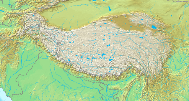
| वर्तमान | 19:51, 26 मार्च 2009 | | 1,365 × 732 (663 KB) | Botev | borders bold, lakes filled in blue |
| 19:02, 2 सितंबर 2005 |  | 1,365 × 732 (710 KB) | Mats Halldin~commonswiki | Map of Himalaya Bounding box West 66°, South 23°, East 108°, North 42°. {{demis-pd}} category:maps of Himalaya |
चित्र का उपयोग
निम्नलिखित पन्ने इस चित्र से जुडते हैं :
चित्र का वैश्विक उपयोग
इस चित्र का उपयोग इन दूसरे विकियों में किया जाता है:
- ar.wikipedia.org पर उपयोग
- ba.wikipedia.org पर उपयोग
- be-tarask.wikipedia.org पर उपयोग
- bn.wikipedia.org पर उपयोग
- ceb.wikipedia.org पर उपयोग
- ce.wikipedia.org पर उपयोग
- da.wikipedia.org पर उपयोग
- de.wikipedia.org पर उपयोग
- en.wikipedia.org पर उपयोग
- Gyachung Kang
- 1950 Assam–Tibet earthquake
- Geladaindong Peak
- Karuo culture
- Haba Snow Mountain
- Anisodus tanguticus
- Outline of Tibet
- Alpine steppe
- Kang Yatze
- Module:Location map/data/Tibetan Plateau/doc
- User:BIO341prj
- 1927 Gulang earthquake
- 1932 Changma earthquake
- Pauhunri
- Guozha Lake
- User:HueSatLum/II
- Singhi Kangri
- Module:Location map/data/Tibetan Plateau
- Gasherbrum VI
- Phrynocephalus vlangalii
- eu.wikipedia.org पर उपयोग
- fa.wikipedia.org पर उपयोग
- fo.wikipedia.org पर उपयोग
- fr.wikipedia.org पर उपयोग
- fr.wikibooks.org पर उपयोग
- gcr.wikipedia.org पर उपयोग
- id.wikipedia.org पर उपयोग
इस चित्र के वैश्विक उपयोग की अधिक जानकारी देखें।