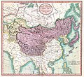
चित्र:1806 Cary Map of Tartary or Central Asia - Geographicus - Tartary-cary-1806.jpg

मूल चित्र((5,000 × 4,569 पिक्सेल, फ़ाइल का आकार: 8.57 MB, MIME प्रकार: image/jpeg))

John Cary: A New Map of Mongolian & Independent Tartary , From the Latest Authorities.   (Wikidata search (Cirrus search) Wikidata query (SPARQL)  Create new Wikidata item based on this file)
कलाकार
John Cary  (–1835)  wikidata:Q3446124 s:en:Author:John Cary
 
वैकल्पिक नाम
J. Cary
विवरण cartographer, engraver, mapseller, printseller और graphic artist
जन्म/मृत्यु तिथि २३ फ़रवरी १७५५ / १७५४ Edit this at Wikidata १६ अगस्त १८३५ Edit this at Wikidata
जन्म/मृत्यु स्थान Corsley मोर्टलेक
कार्य काल १७८८ / १७९३ / १७९७ Edit this at Wikidata
कार्य स्थान
प्राधिकरण नियंत्रण
artist QS:P170,Q3446124
शीर्षक
A New Map of Mongolian & Independent Tartary , From the Latest Authorities.
विवरण
English: An exceptionally beautiful example of John Cary’s important 1806 map of Mongolian and Independent Tartary. Covers Central Asia from the Caspian Sea to Japan, extends as far north as the Obskaia Sea and as far south as India, Burma and the Philippines. Includes the modern day nations of Uzbekistan, Kazakhstan, Turkmenistan, Kirgizstan, Tajikistan and Mongolia. One of Cary’s most interesting maps. Central Asia, despite hundreds of years of passing trade on the Silk Routes, was still, at the turn of the century a largely unknown land. Cary attempts to show some of the Silk Route passages, especially to the north of the Gobi, but ultimately admits, “The Geography of these parts is extremely obscure.” All in all, one of the most interesting and few maps of Central Asia to appear in first years of the 19th century. Prepared in 1806 by John Cary for issue in his magnificent 1808 New Universal Atlas. (NOTE: The reproduction of the colors in this map appear to be incorrect, as Japan and Tibet were never part of Chinese Tartary yet appear to be the same color as it.)
दिनांक १८०६ (dated)
आयाम ऊँचाई: १८.५ in (४६.९ cm); width: २०.० in (५०.८ cm)
dimensions QS:P2048,18.5U218593
dimensions QS:P2049,20U218593
परिग्रहण संख्या
Geographicus link: Tartary-cary-1806
स्रोत/फ़ोटोग्राफ़र

Cary, John, Cary's New Universal Atlas, containing distinct maps of all the principal states and kingdoms throughout the World. From the latest and best authorities extant. London: Printed for J. Cary, Engraver and Map-seller, No. 181, near Norfolk Street, Strand, 1808.

अनुमति
(इस चित्र का पुनः उपयोग करना)
This is a faithful photographic reproduction of a two-dimensional, public domain work of art. The work of art itself is in the public domain for the following reason:
Public domain

This work is in the public domain in its country of origin and other countries and areas where the copyright term is the author's life plus 100 years or fewer.


You must also include a United States public domain tag to indicate why this work is in the public domain in the United States.
The official position taken by the Wikimedia Foundation is that "faithful reproductions of two-dimensional public domain works of art are public domain".
This photographic reproduction is therefore also considered to be in the public domain in the United States. In other jurisdictions, re-use of this content may be restricted; see Reuse of PD-Art photographs for details.
दूसरे संस्करण
Annotations
InfoField
This image is annotated: View the annotations at Commons

Captions

Add a one-line explanation of what this file represents

Items portrayed in this file

चित्रण

MIME type अंग्रेज़ी

image/jpeg

checksum अंग्रेज़ी

3d7f1be3ae7a9539d26d91394bee37e7dc951779

निर्धारण विधि: SHA-1 अंग्रेज़ी

data size अंग्रेज़ी

८९,९०,५११ बाइट

४,५६९ पिक्सल

width अंग्रेज़ी

५,००० पिक्सल

चित्र का इतिहास

फ़ाइलका पुराना अवतरण देखने के लिये दिनांक/समय पर क्लिक करें।

दिनांक/समयथंबनेलआकारसदस्यप्रतिक्रिया
वर्तमान08:56, 19 अगस्त 201908:56, 19 अगस्त 2019 के संस्करण का थंबनेल संस्करण5,000 × 4,569 (8.57 MB)SoerfmBrightness, color
10:56, 22 मार्च 201110:56, 22 मार्च 2011 के संस्करण का थंबनेल संस्करण5,000 × 4,569 (7.81 MB)BotMultichillT{{subst:User:Multichill/Geographicus |link=http://www.geographicus.com/P/AntiqueMap/Tartary-cary-1806 |product_name=1806 Cary Map of Tartary or Central Asia |map_title=A New Map of Chinese & Independent Tartary , From the Latest Authorities. |description=

निम्नलिखित पन्ने इस चित्र से जुडते हैं :

चित्र का वैश्विक उपयोग

इस चित्र का उपयोग इन दूसरे विकियों में किया जाता है:

मेटाडेटा