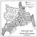
चित्र:19s Bengal province map.jpg

इस पूर्वावलोकन का आकार: 600 × 600 पिक्सेल। दूसरे रेसोल्यूशन्स: 240 × 240 पिक्सेल | 480 × 480 पिक्सेल | 768 × 768 पिक्सेल | 1,080 × 1,080 पिक्सेल।
मूल चित्र ((1,080 × 1,080 पिक्सेल, फ़ाइल का आकार: 237 KB, MIME प्रकार: image/jpeg))
चित्र का इतिहास
फ़ाइलका पुराना अवतरण देखने के लिये दिनांक/समय पर क्लिक करें।
| दिनांक/समय | थंबनेल | आकार | सदस्य | प्रतिक्रिया | |
|---|---|---|---|---|---|
| वर्तमान | 06:04, 14 जनवरी 2023 |  | 1,080 × 1,080 (237 KB) | MaxA-Matrix | Uploaded a work by T. H. HOLLAND from BENGAL BIHAR AND ORISSA SIKKIM, Provincial Geographies of India with UploadWizard |
चित्र का उपयोग
निम्नलिखित पन्ने इस चित्र से जुडते हैं :
चित्र का वैश्विक उपयोग
इस चित्र का उपयोग इन दूसरे विकियों में किया जाता है:
- en.wikipedia.org पर उपयोग