चित्र:Be-map.png

इससे बड़ा रेसोल्यूशन उपलब्ध नहीं हैं।
Be-map.png ((559 × 600 पिक्सेल, फ़ाइल का आकार: 176 KB, MIME प्रकार: image/png))
|
|
यह फ़ाइल विकिमेडिया कॉमन्स से है। वहाँ पर इसका विवरण पृष्ठ निम्नोक्त है। कॉमन्स मुक्त लाइसेंसों के अंतर्गत उपलब्ध मीडिया फ़ाइलों का संग्रह है। आप भी इसमें मदद कर सकते हैं। |

|
This locator map image could be re-created using vector graphics as an SVG file. This has several advantages; see Commons:Media for cleanup for more information. If an SVG form of this image is available, please upload it and afterwards replace this template with
{{vector version available|new image name}}.
It is recommended to name the SVG file “Be-map.svg”—then the template Vector version available (or Vva) does not need the new image name parameter. |
सारांश
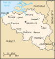
| विवरण | Belgium map from CIA World Factbook (since ८ मई २००६), converted from original GIF format |
| दिनांक | |
| स्रोत |
CIA World Factbook |
| लेखक | United States Central Intelligence Agency |
| दूसरे संस्करण |
|
.png)
लाइसेंस
This image is in the public domain because it contains materials that originally came from the United States Central Intelligence Agency's World Factbook.
|
 |
Derivative works
Derivatives of 2006 map:


Derivatives of 2004 map:


Derivatives of 2000 map:
-
 Belgie-mapa.PNG
čeština -
 Be-map-eo.png
Esperanto -
 Be-map-es.png
español -
 Be-map-fr.png
français -
 Be-map-nl.png
Nederlands -
 Belgium-map-nl.png
Nederlands -
 Belgium üres.png
 -
 Ath in Belgium.png
 -
 Dendermonde location map.png
 -
 Vlaamse ruit.png


चित्र का इतिहास
फ़ाइलका पुराना अवतरण देखने के लिये दिनांक/समय पर क्लिक करें।
| दिनांक/समय | थंबनेल | आकार | सदस्य | प्रतिक्रिया | |
|---|---|---|---|---|---|
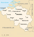
| वर्तमान | 21:48, 13 अप्रैल 2020 | | 559 × 600 (176 KB) | Le Fou | Zeebrugge is not a city, but part of the city of Bruges. |
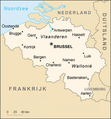
| 19:13, 21 जुलाई 2018 |  | 1,024 × 1,099 (24 KB) | Karel Adriaan | Resized to 1024 | |
| 20:48, 20 अप्रैल 2007 |  | 328 × 353 (12 KB) | Tene~commonswiki | Optimised (0) | |
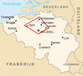
| 17:07, 11 मार्च 2007 |  | 328 × 353 (13 KB) | Feydey | 2007 factbook map | |
| 13:55, 27 मई 2006 |  | 329 × 353 (20 KB) | Matt314 | "Redu" in the same font size as the other cities | |
| 20:59, 7 अप्रैल 2006 |  | 329 × 353 (20 KB) | Abrev | Map of Belgium Updated version uploaded by [http://de.wikipedia.org/wiki/Benutzer:Tzzzpfff]. No rights reserved for updating. | |
| 16:46, 5 जनवरी 2006 |  | 330 × 355 (9 KB) | Jrenier | Reverted to earlier revision | |
| 16:35, 5 जनवरी 2006 |  | 330 × 355 (9 KB) | Jrenier | Reverted to earlier revision | |
| 19:53, 3 जनवरी 2006 |  | 330 × 355 (28 KB) | Iunity | ||
| 19:24, 27 नवम्बर 2004 |  | 330 × 355 (9 KB) | Kneiphof | Map of Belgium, CIA factbook (taken from EN Wikipedia) |
चित्र का उपयोग
निम्नलिखित पन्ने इस चित्र से जुडते हैं :
चित्र का वैश्विक उपयोग
इस चित्र का उपयोग इन दूसरे विकियों में किया जाता है:
- als.wikipedia.org पर उपयोग
- ay.wikipedia.org पर उपयोग
- azb.wikipedia.org पर उपयोग
- az.wikipedia.org पर उपयोग
- bcl.wikipedia.org पर उपयोग
- be-tarask.wikipedia.org पर उपयोग
- bg.wiktionary.org पर उपयोग
- bn.wikipedia.org पर उपयोग
- bs.wikipedia.org पर उपयोग
- ca.wikipedia.org पर उपयोग
- de.wikipedia.org पर उपयोग
- de.wikinews.org पर उपयोग
- dsb.wikipedia.org पर उपयोग
- en.wikipedia.org पर उपयोग
- en.wikinews.org पर उपयोग
- en.wikivoyage.org पर उपयोग
- en.wiktionary.org पर उपयोग
- es.wikipedia.org पर उपयोग
- fa.wikipedia.org पर उपयोग
- fi.wikipedia.org पर उपयोग
- fr.wikipedia.org पर उपयोग
- fr.wikinews.org पर उपयोग
- gag.wikipedia.org पर उपयोग
- ga.wikipedia.org पर उपयोग
- gl.wikipedia.org पर उपयोग
- ha.wikipedia.org पर उपयोग
- hy.wikipedia.org पर उपयोग
- incubator.wikimedia.org पर उपयोग
- io.wikipedia.org पर उपयोग
इस चित्र के वैश्विक उपयोग की अधिक जानकारी देखें।