चित्र:Bgiusca Jirecek Line.jpg
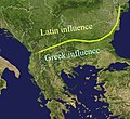
Bgiusca_Jirecek_Line.jpg ((614 × 561 पिक्सेल, फ़ाइल का आकार: 176 KB, MIME प्रकार: image/jpeg))
चित्र का इतिहास
फ़ाइलका पुराना अवतरण देखने के लिये दिनांक/समय पर क्लिक करें।
| दिनांक/समय | थंबनेल | आकार | सदस्य | प्रतिक्रिया | |
|---|---|---|---|---|---|
| वर्तमान | 01:27, 23 फ़रवरी 2022 |  | 614 × 561 (176 KB) | Demetrios1993 | The initial version by User:Bogdan had it correct, but later, the western section of the line was altered without any justification. |
| 10:01, 25 मार्च 2018 |  | 614 × 561 (249 KB) | Trecătorul răcit | Antic shoreline and correct present-day borders | |
| 10:50, 7 अगस्त 2014 |  | 614 × 561 (250 KB) | Spiridon Ion Cepleanu | According with Jirecek's works and the palaeography of Aegyssos, Argamum, Histria, Tomis & Kallatis cities (greek and latin inscriptions until the VIIth cen. after JC) | |
| 09:56, 19 अप्रैल 2005 |  | 614 × 561 (101 KB) | Bogdan | The division between the Greek and the Latin influence in the Balkans during the Roman Empire Source: Public domain work {{GFDL}} Category:Romanian historyCategory:Roman Empire\ |
चित्र का उपयोग
निम्नलिखित पन्ने इस चित्र से जुडते हैं :
चित्र का वैश्विक उपयोग
इस चित्र का उपयोग इन दूसरे विकियों में किया जाता है:
- an.wikipedia.org पर उपयोग
- ar.wikipedia.org पर उपयोग
- ast.wikipedia.org पर उपयोग
- ba.wikipedia.org पर उपयोग
- bg.wikipedia.org पर उपयोग
- ca.wikipedia.org पर उपयोग
- ce.wikipedia.org पर उपयोग
- cs.wikipedia.org पर उपयोग
- cv.wikipedia.org पर उपयोग
- de.wikipedia.org पर उपयोग
- el.wikipedia.org पर उपयोग
- en.wikipedia.org पर उपयोग
- es.wikipedia.org पर उपयोग
- et.wikipedia.org पर उपयोग
- eu.wikipedia.org पर उपयोग
- fa.wikipedia.org पर उपयोग
- fr.wikipedia.org पर उपयोग
- he.wikipedia.org पर उपयोग
- hr.wikipedia.org पर उपयोग
- id.wikipedia.org पर उपयोग
- it.wikipedia.org पर उपयोग
- ja.wikipedia.org पर उपयोग
- ka.wikipedia.org पर उपयोग
- ko.wikipedia.org पर उपयोग
- la.wikipedia.org पर उपयोग
- lt.wikipedia.org पर उपयोग
इस चित्र के वैश्विक उपयोग की अधिक जानकारी देखें।

