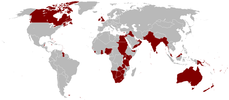
चित्र:British Empire 1921.png

इस पूर्वावलोकन का आकार: 800 × 351 पिक्सेल। दूसरे रेसोल्यूशन्स: 320 × 140 पिक्सेल | 640 × 281 पिक्सेल | 1,425 × 625 पिक्सेल।
मूल चित्र ((1,425 × 625 पिक्सेल, फ़ाइल का आकार: 58 KB, MIME प्रकार: image/png))
चित्र का इतिहास
फ़ाइलका पुराना अवतरण देखने के लिये दिनांक/समय पर क्लिक करें।
| दिनांक/समय | थंबनेल | आकार | सदस्य | प्रतिक्रिया | |
|---|---|---|---|---|---|
| वर्तमान | 03:14, 7 अक्टूबर 2023 |  | 1,425 × 625 (58 KB) | Alanzx123 | added weihaiwei |
| 11:45, 25 जुलाई 2023 |  | 1,425 × 625 (40 KB) | Przemko1 | Bhutan, Sikkim british protectorates | |
| 08:02, 31 अक्टूबर 2021 |  | 1,425 × 625 (40 KB) | Randomastwritter | juba | |
| 22:05, 14 मार्च 2019 |  | 1,425 × 625 (56 KB) | Horserice | Fixed Hong Kong. | |
| 16:27, 5 जून 2017 |  | 1,425 × 625 (31 KB) | Maproom | Altered borders between Egypt, Libya and Sudan to agree with File:BlankMap-World-1921.png, which supposedly shows the correct borders as at 1921. | |
| 19:44, 11 दिसम्बर 2015 |  | 1,425 × 625 (32 KB) | Braganza | Tibet existed until 1949 | |
| 19:35, 3 सितंबर 2015 |  | 1,425 × 625 (35 KB) | फ़िलप्रो | Fixed Nepal, Sikkim, and Bhutan. They were de facto princely states / protectorates of the British Empire. | |
| 21:02, 26 मार्च 2015 |  | 1,425 × 625 (39 KB) | David C. S. | Ecudor in 1921 | |
| 19:00, 7 मई 2011 |  | 1,425 × 625 (49 KB) | Quigley | Correct China's borders closer to what was internationally recognized at the time | |
| 01:33, 13 अक्टूबर 2010 |  | 1,425 × 625 (50 KB) | Vadac | Uploaded a clearer version with traditional British colour, added critical islands in Pacific and Caribbean and fixed the boarders of countries at the time such as Tuva among others |
चित्र का उपयोग
निम्नलिखित पन्ने इस चित्र से जुडते हैं :
चित्र का वैश्विक उपयोग
इस चित्र का उपयोग इन दूसरे विकियों में किया जाता है:
- af.wikipedia.org पर उपयोग
- als.wikipedia.org पर उपयोग
- am.wikipedia.org पर उपयोग
- ar.wikipedia.org पर उपयोग
- ast.wikipedia.org पर उपयोग
- azb.wikipedia.org पर उपयोग
- az.wikipedia.org पर उपयोग
- bg.wikipedia.org पर उपयोग
- bn.wikipedia.org पर उपयोग
- br.wikipedia.org पर उपयोग
- ca.wikipedia.org पर उपयोग
- cs.wikipedia.org पर उपयोग
- da.wikipedia.org पर उपयोग
- de.wikipedia.org पर उपयोग
- el.wikipedia.org पर उपयोग
- en.wikipedia.org पर उपयोग
इस चित्र के वैश्विक उपयोग की अधिक जानकारी देखें।
