चित्र:Carte de la Manche.png

इस पूर्वावलोकन का आकार: 800 × 447 पिक्सेल। दूसरे रेसोल्यूशन्स: 320 × 179 पिक्सेल | 832 × 465 पिक्सेल।
मूल चित्र ((832 × 465 पिक्सेल, फ़ाइल का आकार: 107 KB, MIME प्रकार: image/png))
|
|
यह फ़ाइल विकिमेडिया कॉमन्स से है। वहाँ पर इसका विवरण पृष्ठ निम्नोक्त है। कॉमन्स मुक्त लाइसेंसों के अंतर्गत उपलब्ध मीडिया फ़ाइलों का संग्रह है। आप भी इसमें मदद कर सकते हैं। |
सारांश
| विवरण |
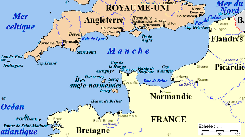
Français : Carte de la Manche avec la situation des caps principaux, des îles et des villes importantes. Projection de Mercator, données de 2005. Fond de carte provenant de [www.aquarius.geomar.de www.aquarius.geomar.de] (défunt).
English: Channel map with main capes, islands and cities. Projection of Mercator, data as of 2005. Map background from [www.aquarius.geomar.de www.aquarius.geomar.de] (defunct). |
| दिनांक | ४ जून २००५, १६:५२ (original upload date) |
| स्रोत | अपना कार्य |
| लेखक | Idarvol (वार्ता · योगदान) |

|
This map image could be re-created using vector graphics as an SVG file. This has several advantages; see Commons:Media for cleanup for more information. If an SVG form of this image is available, please upload it and afterwards replace this template with
{{vector version available|new image name}}.
It is recommended to name the SVG file “Carte de la Manche.svg”—then the template Vector version available (or Vva) does not need the new image name parameter. |
लाइसेंस
मैं, इस कार्य का/की कॉपीराइट धारक, इसे निम्न लाइसेंस के अंतर्गत प्रकाशित करता/करती हूँ:

|
इस दस्तावेज़ को Free Software Foundation द्वारा प्रकाशित GNU मुक्त प्रलेख लाइसेंस के संस्करण 1.2 या नए (बिना किसी अपरिवर्तनीय अनुभागों और अगले या पिछले आवरण के टेक्स्ट के) के अंतर्गत प्रतिलिपि बनाने, बाँटने और/या बदलने की अनुमति प्रदान की जाती है। इस लाइसेंस की एक प्रतिलिपि GNU मुक्त प्रलेख लाइसेंस नामक अनुभाग में शामिल है। |
| इस फ़ाइल को क्रिएटिव कॉमन्स श्रेय-समानसांझा 3.0 अनरिपोर्टेड लाइसेंस के अंतर्गत लाइसेंस किया गया है। | ||
| ||
| This licensing tag was added to this file as part of the GFDL licensing update. |
चित्र का इतिहास
फ़ाइलका पुराना अवतरण देखने के लिये दिनांक/समय पर क्लिक करें।
| दिनांक/समय | थंबनेल | आकार | सदस्य | प्रतिक्रिया | |
|---|---|---|---|---|---|
| वर्तमान | 17:19, 16 नवम्बर 2020 | | 832 × 465 (107 KB) | Hohum | Cartographic colours |
| 02:40, 3 फ़रवरी 2016 |  | 832 × 465 (99 KB) | Ptyx | Ouesssant > Ouessant | |
| 17:31, 15 फ़रवरी 2011 |  | 832 × 465 (71 KB) | Mahahahaneapneap | Compressed | |
| 16:52, 4 जून 2005 |  | 832 × 465 (105 KB) | Idarvol | Carte de la Manche. |
चित्र का उपयोग
निम्नलिखित पन्ने इस चित्र से जुडते हैं :
चित्र का वैश्विक उपयोग
इस चित्र का उपयोग इन दूसरे विकियों में किया जाता है:
- af.wikipedia.org पर उपयोग
- br.wikipedia.org पर उपयोग
- bs.wikipedia.org पर उपयोग
- ca.wikipedia.org पर उपयोग
- cs.wikipedia.org पर उपयोग
- de.wikipedia.org पर उपयोग
- en.wikipedia.org पर उपयोग
- es.wikipedia.org पर उपयोग
- fr.wikipedia.org पर उपयोग
- fr.wiktionary.org पर उपयोग
- gd.wikipedia.org पर उपयोग
- ja.wikipedia.org पर उपयोग
- ka.wikipedia.org पर उपयोग
- kw.wikipedia.org पर उपयोग
- pa.wikipedia.org पर उपयोग
- pl.wiktionary.org पर उपयोग
- scn.wikipedia.org पर उपयोग
- sr.wikipedia.org पर उपयोग
- xmf.wikipedia.org पर उपयोग
- zh.wikipedia.org पर उपयोग