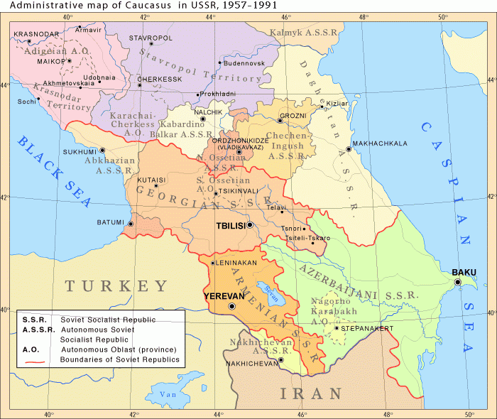
चित्र:Caucasiamapussr.gif
इससे बड़ा रेसोल्यूशन उपलब्ध नहीं हैं।
Caucasiamapussr.gif ((700 × 590 पिक्सेल, फ़ाइल का आकार: 81 KB, MIME प्रकार: image/gif))
|
|
यह फ़ाइल विकिमेडिया कॉमन्स से है। वहाँ पर इसका विवरण पृष्ठ निम्नोक्त है। कॉमन्स मुक्त लाइसेंसों के अंतर्गत उपलब्ध मीडिया फ़ाइलों का संग्रह है। आप भी इसमें मदद कर सकते हैं। |

|
File:Soviet Caucasus map.svg is a vector version of this file. It should be used in place of this GIF file when not inferior.
File:Caucasiamapussr.gif → File:Soviet Caucasus map.svg
For more information, see Help:SVG. |
 |
सारांश
| विवरण |
English: Administrative map of Caucasus in USSR, 1952-1991 |
| दिनांक |
Uploaded to Armenica.org before ७ दिसम्बर २००६ (archived version)
|
| स्रोत | Originally uploded from en.wikipedia; description page is/was here. |
| लेखक | www.armenica.org |
| दूसरे संस्करण | العربيَّة |
लाइसेंस

|
इस दस्तावेज़ को Free Software Foundation द्वारा प्रकाशित GNU मुक्त प्रलेख लाइसेंस के संस्करण 1.2 या नए (बिना किसी अपरिवर्तनीय अनुभागों और अगले या पिछले आवरण के टेक्स्ट के) के अंतर्गत प्रतिलिपि बनाने, बाँटने और/या बदलने की अनुमति प्रदान की जाती है। इस लाइसेंस की एक प्रतिलिपि GNU मुक्त प्रलेख लाइसेंस नामक अनुभाग में शामिल है। |
This permission only applies to images existing on http://armenica.org/ as of 1 January 2007. Any later images do not fall under this permission!
मूल अपलोड लॉग
(All user names refer to en.wikipedia)
- 2007-01-03 03:06 Artaxiad 700×590×6 (60613 bytes) Administrative map of [[Caucasus]] in USSR, 1952-1991 Source: Armenica.org [[Category:Armenica images]]
चित्र का इतिहास
फ़ाइलका पुराना अवतरण देखने के लिये दिनांक/समय पर क्लिक करें।
| दिनांक/समय | थंबनेल | आकार | सदस्य | प्रतिक्रिया | |
|---|---|---|---|---|---|
| वर्तमान | 16:30, 10 मई 2012 | | 700 × 590 (81 KB) | M0tty | Licence autorising modification → remove watermark |
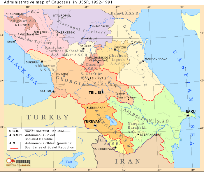
| 20:03, 5 मई 2012 |  | 700 × 591 (78 KB) | Geagea | Original map according to the OTRS permission. Not to be reverted. | |
| 04:49, 27 मार्च 2011 |  | 700 × 590 (81 KB) | Hellerick | The earlier changes were correct. | |
| 19:12, 16 जनवरी 2011 |  | 700 × 590 (59 KB) | Geagea | Reverted to version as of 10:16, 24 February 2007. To the uploader's last version | |
| 18:38, 16 जनवरी 2011 |  | 700 × 590 (81 KB) | Nicolay Sidorov | Adygea to Krasnodar, Karachay-Cherkess to Stavropol. | |
| 18:31, 16 जनवरी 2011 |  | 700 × 590 (80 KB) | Nicolay Sidorov | The Chechen-Ingush republic was restored on January 9, 1957 | |
| 10:16, 24 फ़रवरी 2007 |  | 700 × 590 (59 KB) | Hardscarf | {{Information |Description=Administrative map of en:Caucasus in USSR, 1952-1991 |Source=Armenica.org {{ConfirmationImageOTRS|source=http://armenica.org/|otrs=2007010210006387}} Originally from [http://en.wikipedia.org en.wikipedia]; description page |
चित्र का उपयोग
निम्नलिखित पन्ने इस चित्र से जुडते हैं :
चित्र का वैश्विक उपयोग
इस चित्र का उपयोग इन दूसरे विकियों में किया जाता है:
- ar.wikipedia.org पर उपयोग
- azb.wikipedia.org पर उपयोग
- az.wikipedia.org पर उपयोग
- ca.wikipedia.org पर उपयोग
- el.wikipedia.org पर उपयोग
- en.wikipedia.org पर उपयोग
- et.wikipedia.org पर उपयोग
- fi.wikipedia.org पर उपयोग
- fo.wikipedia.org पर उपयोग
- he.wikipedia.org पर उपयोग
- hr.wikipedia.org पर उपयोग
- id.wikipedia.org पर उपयोग
- is.wikipedia.org पर उपयोग
- ja.wikipedia.org पर उपयोग
- jv.wikipedia.org पर उपयोग
- ko.wikipedia.org पर उपयोग
- nn.wikipedia.org पर उपयोग
- no.wikipedia.org पर उपयोग
- pl.wiktionary.org पर उपयोग
- ro.wikipedia.org पर उपयोग
- ru.wikipedia.org पर उपयोग
- simple.wikipedia.org पर उपयोग
- so.wikipedia.org पर उपयोग
- ta.wikipedia.org पर उपयोग
- tl.wikipedia.org पर उपयोग
- tr.wikipedia.org पर उपयोग
- uk.wikipedia.org पर उपयोग
- vi.wikipedia.org पर उपयोग