चित्र:Chennai revenue divisions map.png
इस पूर्वावलोकन का आकार: 484 × 599 पिक्सेल। दूसरे रेसोल्यूशन्स: 194 × 240 पिक्सेल | 388 × 480 पिक्सेल | 620 × 768 पिक्सेल | 1,223 × 1,514 पिक्सेल।
मूल चित्र ((1,223 × 1,514 पिक्सेल, फ़ाइल का आकार: 181 KB, MIME प्रकार: image/png))
|
|
यह फ़ाइल विकिमेडिया कॉमन्स से है। वहाँ पर इसका विवरण पृष्ठ निम्नोक्त है। कॉमन्स मुक्त लाइसेंसों के अंतर्गत उपलब्ध मीडिया फ़ाइलों का संग्रह है। आप भी इसमें मदद कर सकते हैं। |

|
This map image could be re-created using vector graphics as an SVG file. This has several advantages; see Commons:Media for cleanup for more information. If an SVG form of this image is available, please upload it and afterwards replace this template with
{{vector version available|new image name}}.
It is recommended to name the SVG file “Chennai revenue divisions map.svg”—then the template Vector version available (or Vva) does not need the new image name parameter. |
सारांश
| विवरण |
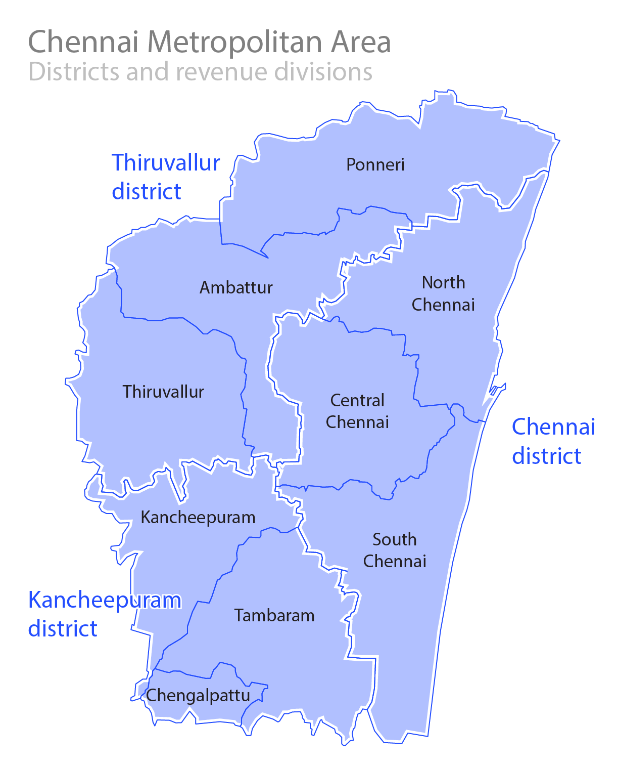
English: Revenue divisions and districts in the Chennai Metropolitan Area. தமிழ்: சென்னை மாநகர பரப்பில் உள்ள மாவட்டங்கள் மற்றும் கோட்டங்கள். |
||
| दिनांक |
26 August 2008 (original) 9 January 2015 (update) 7 January 2018 (update x2) |
||
| स्रोत | अपना कार्य | ||
| लेखक |
|
||
| अनुमति (इस चित्र का पुनः उपयोग करना) |
Own Work. See below for license. |
लाइसेंस
मैं, इस कार्य का/की कॉपीराइट धारक, इसे निम्न लाइसेंस के अंतर्गत प्रकाशित करता/करती हूँ:
इस फ़ाइल को क्रिएटिव कॉमन्स श्रेय-समानसांझा 3.0 अनरिपोर्टेड लाइसेंस के अंतर्गत लाइसेंस किया गया है।
- आप खुलकर:
- बाँट सकते हैं – रचना की प्रतिलिपि बना सकते हैं, बाँँट सकते हैं और संचारित कर सकते हैं
- रीमिक्स कर सकते हैं – कार्य को अनुकूलित कर सकते हैं
- निम्नलिखित शर्तों के अंतर्गत:
- श्रेय – यह अनिवार्य है कि आप यथोचित श्रेय प्रदान करें, लाइसेंस की कड़ी प्रदान करें, और अगर कोई बदलाव हुए हों तो उन्हें इंगित करें। आप ऐसा किसी भी उचित तरीके से कर सकते हैं, लेकिन किसी भी तरह उससे यह नहीं संकेत नहीं किया जाना चाहिए कि लाइसेंसधारी द्वारा आपको अथवा आपके इस प्रयोग का समर्थन किया जा रहा हो।
- समानसांझा – अगर आप इस रचना में कोई बदलाव करते हैं या इसपर आधारित कुछ रचित करते हैं तो आप अपने योगदान को सिर्फ इसी या इसके सामान किसी लाइसेंस के अंतर्गत बाँट सकते हैं।
चित्र का इतिहास
फ़ाइलका पुराना अवतरण देखने के लिये दिनांक/समय पर क्लिक करें।
| दिनांक/समय | थंबनेल | आकार | सदस्य | प्रतिक्रिया | |
|---|---|---|---|---|---|
| वर्तमान | 15:30, 7 जनवरी 2018 | | 1,223 × 1,514 (181 KB) | Nirinsanity | Updated image with expanded boundaries of the Chennai district |
| 01:35, 9 जनवरी 2015 |  | 1,245 × 1,449 (436 KB) | Nirinsanity | Corrected Revenue Divisions, Taluks and also updated them. | |
| 17:33, 25 अगस्त 2008 |  | 1,053 × 1,278 (53 KB) | Planemad | {{Information |Description={{en|1=Districts ans Subdistricts in the Chennai Metropolitan Area.}} |Source=Own work by uploader |Author=PlaneMad |Date= |Permission= |other_versions= }} <!--{{ImageUpload|full}}--> |
चित्र का उपयोग
निम्नलिखित पन्ने इस चित्र से जुडते हैं :
चित्र का वैश्विक उपयोग
इस चित्र का उपयोग इन दूसरे विकियों में किया जाता है:
- bn.wikipedia.org पर उपयोग
- ca.wikipedia.org पर उपयोग
- de.wikipedia.org पर उपयोग
- he.wikipedia.org पर उपयोग
- no.wikipedia.org पर उपयोग
- sat.wikipedia.org पर उपयोग
- ta.wikipedia.org पर उपयोग
- te.wikipedia.org पर उपयोग
- www.wikidata.org पर उपयोग
- zh.wikipedia.org पर उपयोग