चित्र:Cn-map.png
इससे बड़ा रेसोल्यूशन उपलब्ध नहीं हैं।
Cn-map.png ((330 × 355 पिक्सेल, फ़ाइल का आकार: 6 KB, MIME प्रकार: image/png))
|
|
यह फ़ाइल विकिमेडिया कॉमन्स से है। वहाँ पर इसका विवरण पृष्ठ निम्नोक्त है। कॉमन्स मुक्त लाइसेंसों के अंतर्गत उपलब्ध मीडिया फ़ाइलों का संग्रह है। आप भी इसमें मदद कर सकते हैं। |

|
This locator map image could be re-created using vector graphics as an SVG file. This has several advantages; see Commons:Media for cleanup for more information. If an SVG form of this image is available, please upload it and afterwards replace this template with
{{vector version available|new image name}}.
It is recommended to name the SVG file “Cn-map.svg”—then the template Vector version available (or Vva) does not need the new image name parameter. |
सारांश
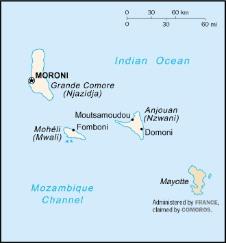
CIA map of the Comoros
लाइसेंस
This image is in the public domain because it contains materials that originally came from the United States Central Intelligence Agency's World Factbook.
|
 |
derivative works
Derivative works of this file:
चित्र का इतिहास
फ़ाइलका पुराना अवतरण देखने के लिये दिनांक/समय पर क्लिक करें।
| दिनांक/समय | थंबनेल | आकार | सदस्य | प्रतिक्रिया | |
|---|---|---|---|---|---|
| वर्तमान | 20:13, 28 फ़रवरी 2005 | | 330 × 355 (6 KB) | Alfio | CIA map of Comoros |
चित्र का उपयोग
निम्नलिखित पन्ने इस चित्र से जुडते हैं :
चित्र का वैश्विक उपयोग
इस चित्र का उपयोग इन दूसरे विकियों में किया जाता है:
- ab.wikipedia.org पर उपयोग
- als.wikipedia.org पर उपयोग
- ar.wikipedia.org पर उपयोग
- ast.wikipedia.org पर उपयोग
- be-tarask.wikipedia.org पर उपयोग
- be.wikipedia.org पर उपयोग
- bjn.wikipedia.org पर उपयोग
- bn.wikipedia.org पर उपयोग
- bs.wikipedia.org पर उपयोग
- ceb.wikipedia.org पर उपयोग
- cy.wikipedia.org पर उपयोग
- da.wikipedia.org पर उपयोग
- de.wikinews.org पर उपयोग
- el.wikipedia.org पर उपयोग
- en.wikipedia.org पर उपयोग
- es.wikipedia.org पर उपयोग
- eu.wikipedia.org पर उपयोग
- fa.wikipedia.org पर उपयोग
- fi.wikipedia.org पर उपयोग
- frr.wikipedia.org पर उपयोग
- fr.wikipedia.org पर उपयोग
- fr.wikinews.org पर उपयोग
- gd.wikipedia.org पर उपयोग
- gl.wikipedia.org पर उपयोग
- he.wikipedia.org पर उपयोग
- hi.wiktionary.org पर उपयोग
- hu.wikipedia.org पर उपयोग
- hu.wiktionary.org पर उपयोग
- id.wikipedia.org पर उपयोग
इस चित्र के वैश्विक उपयोग की अधिक जानकारी देखें।