चित्र:Curaçao1836.png
इस पूर्वावलोकन का आकार: 722 × 599 पिक्सेल। दूसरे रेसोल्यूशन्स: 289 × 240 पिक्सेल | 578 × 480 पिक्सेल | 925 × 768 पिक्सेल | 1,234 × 1,024 पिक्सेल | 2,366 × 1,964 पिक्सेल।
मूल चित्र ((2,366 × 1,964 पिक्सेल, फ़ाइल का आकार: 8.15 MB, MIME प्रकार: image/png))
|
|
यह फ़ाइल विकिमेडिया कॉमन्स से है। वहाँ पर इसका विवरण पृष्ठ निम्नोक्त है। कॉमन्स मुक्त लाइसेंसों के अंतर्गत उपलब्ध मीडिया फ़ाइलों का संग्रह है। आप भी इसमें मदद कर सकते हैं। |
सारांश
| विवरण |
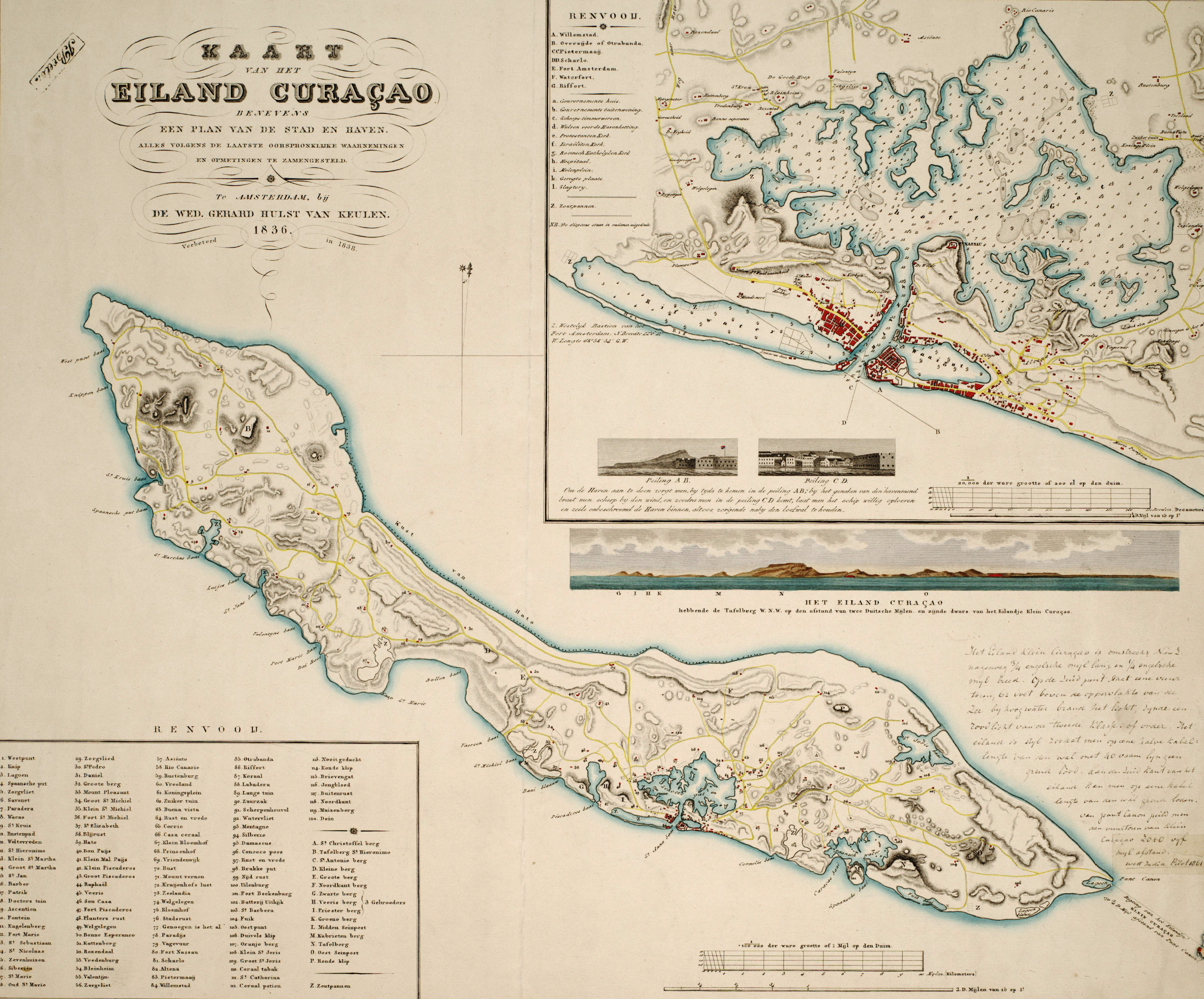
Kaart van het eiland Curaçao : benevens een plan van de stad en haven / alles volgens de laatste oorspronklijke waarnemingen en opmetingen te zamengesteld, 1836 ; verbeterd in 1838; naar de teekening van R.F. van Raders ; gegraveerd door Dl. Veelwaard Junior, Te Amsterdam : by de Wed. Gerard Hulst van Keulen, 1838 Nederlands: Kaart van Curaçao in 1836. English: Map of Curaçao in 1836. |
| दिनांक | 1836, 1838 |
| स्रोत | University of Amsterdam Library |
| लेखक | R.F./van Raders, Daniël Veelwaard jr. (II) |
लाइसेंस
|
This is a faithful photographic reproduction of a two-dimensional, public domain work of art. The work of art itself is in the public domain for the following reason:
The official position taken by the Wikimedia Foundation is that "faithful reproductions of two-dimensional public domain works of art are public domain".
This photographic reproduction is therefore also considered to be in the public domain in the United States. In other jurisdictions, re-use of this content may be restricted; see Reuse of PD-Art photographs for details. | ||||
चित्र का इतिहास
फ़ाइलका पुराना अवतरण देखने के लिये दिनांक/समय पर क्लिक करें।
| दिनांक/समय | थंबनेल | आकार | सदस्य | प्रतिक्रिया | |
|---|---|---|---|---|---|
| वर्तमान | 12:21, 31 दिसम्बर 2010 | | 2,366 × 1,964 (8.15 MB) | Sreejithk2000 | Removed border |
| 17:02, 27 मई 2009 |  | 2,770 × 2,499 (8.45 MB) | Fentener van Vlissingen | {{Information |Description=Kaart van het eiland Curaçao : benevens een plan van de stad en haven / alles volgens de laatste oorspronklijke waarnemingen en opmetingen te zamengesteld, 1836 ; verbeterd in 1838; naar de teekening van R.F. van Raders ; gegra |
चित्र का उपयोग
निम्नलिखित पन्ने इस चित्र से जुडते हैं :
चित्र का वैश्विक उपयोग
इस चित्र का उपयोग इन दूसरे विकियों में किया जाता है:
- ba.wikipedia.org पर उपयोग
- en.wikipedia.org पर उपयोग
- es.wikipedia.org पर उपयोग
- fo.wikipedia.org पर उपयोग
- ha.wikipedia.org पर उपयोग
- id.wikipedia.org पर उपयोग
- mt.wikipedia.org पर उपयोग
- nds-nl.wikipedia.org पर उपयोग
- nl.wikipedia.org पर उपयोग
- no.wikipedia.org पर उपयोग
- pt.wikipedia.org पर उपयोग
- ru.wikipedia.org पर उपयोग
- sl.wikipedia.org पर उपयोग
- uk.wikipedia.org पर उपयोग
- vi.wikipedia.org पर उपयोग