चित्र:Cypress structure.jpeg
इस पूर्वावलोकन का आकार: 800 × 521 पिक्सेल। दूसरे रेसोल्यूशन्स: 320 × 208 पिक्सेल | 640 × 416 पिक्सेल | 1,024 × 666 पिक्सेल | 1,280 × 833 पिक्सेल | 2,560 × 1,666 पिक्सेल | 3,590 × 2,336 पिक्सेल।
मूल चित्र ((3,590 × 2,336 पिक्सेल, फ़ाइल का आकार: 9.9 MB, MIME प्रकार: image/jpeg))
|
|
यह फ़ाइल विकिमेडिया कॉमन्स से है। वहाँ पर इसका विवरण पृष्ठ निम्नोक्त है। कॉमन्स मुक्त लाइसेंसों के अंतर्गत उपलब्ध मीडिया फ़ाइलों का संग्रह है। आप भी इसमें मदद कर सकते हैं। |
सारांश
| विवरण |
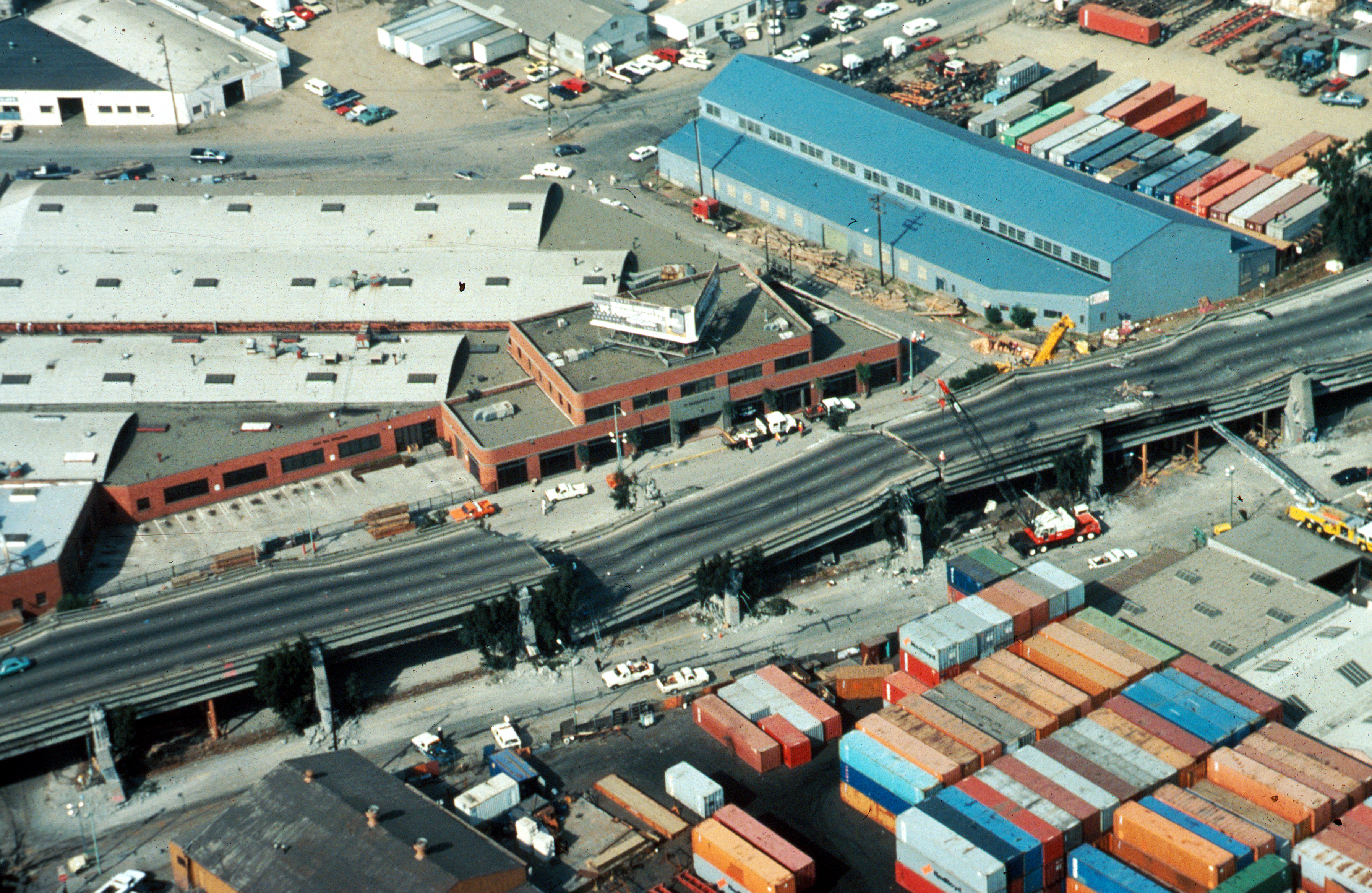
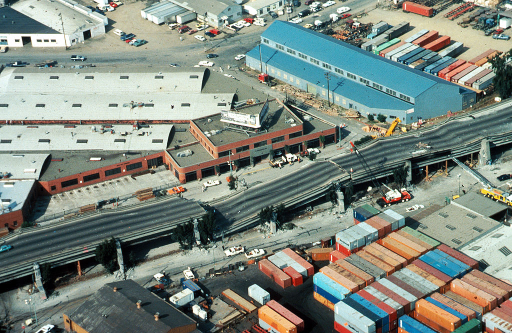
USGS photo from 1989 Loma Prieta earthquake. Caption: Aerial view of collapsed sections of the en:Cypress Viaduct of en:Interstate 880. [H.G. Wilshire, U.S. Geological Survey] |
| दिनांक | |
| स्रोत |
Photo by H. G. Wilshire for U.S. Geological Survey. High res version on line at : [1] Lower resolution version: Original image here: http://pubs.usgs.gov/dds/dds-29/web_pages/oakland.html |
| लेखक | H.G. Wilshire, U.S. Geological Survey |
| अनुमति (इस चित्र का पुनः उपयोग करना) |
PD-USGOV-INTERIOR-USGS. |
| दूसरे संस्करण |
|

लाइसेंस
This image is in the public domain in the United States because it only contains materials that originally came from the United States Geological Survey, an agency of the United States Department of the Interior. For more information, see the official USGS copyright policy.
|
चित्र का इतिहास
फ़ाइलका पुराना अवतरण देखने के लिये दिनांक/समय पर क्लिक करें।
| दिनांक/समय | थंबनेल | आकार | सदस्य | प्रतिक्रिया | |
|---|---|---|---|---|---|
| वर्तमान | 17:57, 16 अक्टूबर 2009 | | 3,590 × 2,336 (9.9 MB) | Infrogmation | High res version |
| 05:27, 30 नवम्बर 2006 |  | 763 × 512 (64 KB) | Zzyzx11 | {{Information |Description=[http://wrgis.wr.usgs.gov/dds/dds-29/ USGS photo] from 1989 en:Loma Prieta earthquake. '''Caption''': Aerial view of collapsed sections of the en:Cypress Viaduct of en:Interstate 880. [H.G. Wilshire, U.S. Geolo |
चित्र का उपयोग
निम्नलिखित पन्ने इस चित्र से जुडते हैं :
चित्र का वैश्विक उपयोग
इस चित्र का उपयोग इन दूसरे विकियों में किया जाता है:
- af.wikipedia.org पर उपयोग
- ar.wikipedia.org पर उपयोग
- azb.wikipedia.org पर उपयोग
- az.wikipedia.org पर उपयोग
- bg.wikipedia.org पर उपयोग
- da.wikipedia.org पर उपयोग
- de.wikipedia.org पर उपयोग
- de.wikivoyage.org पर उपयोग
- en.wikipedia.org पर उपयोग
- Oakland, California
- 1989 Loma Prieta earthquake
- Interstate 880 (California)
- Wikipedia:Selected anniversaries/October 17
- MacArthur Maze
- Cypress Street Viaduct
- Portal:San Francisco Bay Area/Selected article/Archive
- Seismic microzonation
- User:Jer10 95/earthquakeprone
- User:DiRkdARyL
- Wikipedia talk:WikiProject Userboxes/New Userboxes/Archive 13
- 1989 in the United States
- Portal:San Francisco Bay Area/Selected article/18
- es.wikipedia.org पर उपयोग
- fi.wikipedia.org पर उपयोग
- he.wikipedia.org पर उपयोग
- id.wikipedia.org पर उपयोग
- it.wikipedia.org पर उपयोग
- ja.wikipedia.org पर उपयोग
- ko.wikipedia.org पर उपयोग
- ms.wikipedia.org पर उपयोग
- pam.wikipedia.org पर उपयोग
- pl.wikipedia.org पर उपयोग
- pt.wikipedia.org पर उपयोग
- ro.wikipedia.org पर उपयोग
- ru.wikipedia.org पर उपयोग
- simple.wikipedia.org पर उपयोग
- sr.wikipedia.org पर उपयोग
- sv.wikipedia.org पर उपयोग
- th.wikipedia.org पर उपयोग
- tr.wikipedia.org पर उपयोग
- uk.wikipedia.org पर उपयोग
इस चित्र के वैश्विक उपयोग की अधिक जानकारी देखें।