चित्र:Districts and tehsils of Pakistan.png

इस पूर्वावलोकन का आकार: 635 × 599 पिक्सेल। दूसरे रेसोल्यूशन्स: 254 × 240 पिक्सेल | 509 × 480 पिक्सेल | 814 × 768 पिक्सेल | 1,085 × 1,024 पिक्सेल | 1,496 × 1,412 पिक्सेल।
मूल चित्र ((1,496 × 1,412 पिक्सेल, फ़ाइल का आकार: 76 KB, MIME प्रकार: image/png))
|
|
यह फ़ाइल विकिमेडिया कॉमन्स से है। वहाँ पर इसका विवरण पृष्ठ निम्नोक्त है। कॉमन्स मुक्त लाइसेंसों के अंतर्गत उपलब्ध मीडिया फ़ाइलों का संग्रह है। आप भी इसमें मदद कर सकते हैं। |

|
File:Map of Pakistan (2017).svg is a vector version of this file. It should be used in place of this PNG file when not inferior.
File:Districts and tehsils of Pakistan.png → File:Map of Pakistan (2017).svg
For more information, see Help:SVG. |
.svg) |
|
|
File:Map of Pakistan (2018).svg is a vector version of this file. It should be used in place of this PNG file when not inferior.
File:Districts and tehsils of Pakistan.png → File:Map of Pakistan (2018).svg
For more information, see Help:SVG. |
.svg) |
सारांश
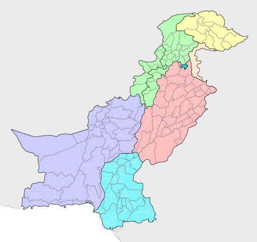
| विवरण | Map of the districts of Pakistan, with their constituent tehsils (thin white borders). Map includes the disputed areas. Created by Rarelibra 20:47, 31 October 2007 (UTC) for public domain use, using MapInfo Professional v8.5 and various mapping resources. |
| दिनांक | ३१ अक्टूबर २००७ (original upload date) |
| स्रोत | अपना कार्य |
| लेखक | Rarelibra |
लाइसेंस
| मैं, इस कार्य का/की कॉपीराइट धारक, इस कार्य को सार्वजनिक डोमेन में प्रकाशित करता/करती हूँ। यह पूरे विश्व में लागू होता है। कुछ देशों में यह कानूनी तौर पर नहीं हो सकता है; ऐसा हो तो: मैं सभी को इस कार्य का इस्तेमाल किसी भी उद्देश्य से, बिना किसी बाधाओं के इन शर्तों के कानून द्वारा अनिवार्य किए तक करने की अनुमति देता/देती हूँ। |
चित्र का इतिहास
फ़ाइलका पुराना अवतरण देखने के लिये दिनांक/समय पर क्लिक करें।
| दिनांक/समय | थंबनेल | आकार | सदस्य | प्रतिक्रिया | |
|---|---|---|---|---|---|
| वर्तमान | 21:16, 9 मई 2019 | | 1,496 × 1,412 (76 KB) | Milenioscuro | recolored, cut out leftover areas |
| 10:44, 13 जून 2018 |  | 2,112 × 1,632 (110 KB) | Balti sahib | Added the districts of Northern Pakistan (G-baltista), also included Fata into KPK province as per administeratives changes because of Fata Reforms; which merged Fata into KPK province. | |
| 16:14, 8 अगस्त 2010 |  | 2,112 × 1,632 (138 KB) | AnonyLog | Aksai Chin is not claimed by Pakistan; this is too complicated to have as currently represented. Also indicates to a newcomer to Pakistan that it administers all of J&K as one district!.. | |
| 13:03, 13 नवम्बर 2009 |  | 2,112 × 1,632 (142 KB) | Nomi887 | Added Disputed Kashmir Regions and also added colours for more clarity. | |
| 20:47, 31 अक्टूबर 2007 |  | 2,112 × 1,632 (72 KB) | Rarelibra | Map of the tehsils of Pakistan. Map includes the disputed areas. Created by ~~~~ for public domain use, using MapInfo Professional v8.5 and various mapping resources. |
चित्र का उपयोग
निम्नलिखित पन्ने इस चित्र से जुडते हैं :
चित्र का वैश्विक उपयोग
इस चित्र का उपयोग इन दूसरे विकियों में किया जाता है:
- ar.wikipedia.org पर उपयोग
- awa.wikipedia.org पर उपयोग
- ba.wikipedia.org पर उपयोग
- be-tarask.wikipedia.org पर उपयोग
- bg.wikipedia.org पर उपयोग
- bn.wikipedia.org पर उपयोग
- bxr.wikipedia.org पर उपयोग
- diq.wikipedia.org पर उपयोग
- dty.wikipedia.org पर उपयोग
- en.wikipedia.org पर उपयोग
- fa.wikipedia.org पर उपयोग
- gl.wikipedia.org पर उपयोग
- incubator.wikimedia.org पर उपयोग
- inh.wikipedia.org पर उपयोग
- it.wikipedia.org पर उपयोग
- ka.wikipedia.org पर उपयोग
- lez.wikipedia.org पर उपयोग
- mai.wikipedia.org पर उपयोग
- ms.wikipedia.org पर उपयोग
- new.wikipedia.org पर उपयोग
- nl.wikipedia.org पर उपयोग
- pa.wikipedia.org पर उपयोग
- pnb.wikipedia.org पर उपयोग
- ps.wikipedia.org पर उपयोग
- pt.wikipedia.org पर उपयोग
- ru.wikipedia.org पर उपयोग
- sd.wikipedia.org पर उपयोग
- simple.wikipedia.org पर उपयोग
- tg.wikipedia.org पर उपयोग
- tl.wikipedia.org पर उपयोग
- uk.wikipedia.org पर उपयोग
- ur.wikipedia.org पर उपयोग
इस चित्र के वैश्विक उपयोग की अधिक जानकारी देखें।