चित्र:Flusssystemkarte Rhein 04.jpg

इस पूर्वावलोकन का आकार: 441 × 599 पिक्सेल। दूसरे रेसोल्यूशन्स: 177 × 240 पिक्सेल | 353 × 480 पिक्सेल | 565 × 768 पिक्सेल | 754 × 1,024 पिक्सेल | 1,508 × 2,048 पिक्सेल | 3,198 × 4,344 पिक्सेल।
मूल चित्र ((3,198 × 4,344 पिक्सेल, फ़ाइल का आकार: 11.72 MB, MIME प्रकार: image/jpeg))
|
|
यह फ़ाइल विकिमेडिया कॉमन्स से है। वहाँ पर इसका विवरण पृष्ठ निम्नोक्त है। कॉमन्स मुक्त लाइसेंसों के अंतर्गत उपलब्ध मीडिया फ़ाइलों का संग्रह है। आप भी इसमें मदद कर सकते हैं। |
सारांश
| विवरण |
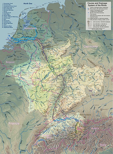
English: Rhine course and river system, place names in English Deutsch: Rheinlauf und Flusssystem, englisch beschriftet Français : Cours du Rhin et son bassin versant, noms de lieux en anglais Nederlands: Verloop en rivierensysteem van de Rijn, plaatsnamen in Engels |
| दिनांक | |
| स्रोत | अपना कार्य |
| लेखक | WWasser |
| दूसरे संस्करण | Versions in german, french, dutch, or with local names. For other languages the unlabelled version may be used. There are also less detailed maps of the river system with either german, english, french, dutch, or local names. A small version without names is available, too. |
| कैमरा स्थान | | यह और अन्य आसपास की छवियों यहां पर देखें: ओपन स्ट्रीट मैप |
|---|
- Background relief created with Google Maps-For-Free SRTM3 Webserver
- Topography derived from Open Street Map
- Outlines of catchment areas derived from relief data (in the Netherlands also taken from several ICPR (International Commission for the Protection of the Rhine)- and Rijkswaterstaat-publications)
लाइसेंस
मैं, इस कार्य का/की कॉपीराइट धारक, इसे निम्न लाइसेंस के अंतर्गत प्रकाशित करता/करती हूँ:
इस फ़ाइल को क्रिएटिव कॉमन्स श्रेय-समानसांझा 3.0 अनरिपोर्टेड लाइसेंस के अंतर्गत लाइसेंस किया गया है।
- आप खुलकर:
- बाँट सकते हैं – रचना की प्रतिलिपि बना सकते हैं, बाँँट सकते हैं और संचारित कर सकते हैं
- रीमिक्स कर सकते हैं – कार्य को अनुकूलित कर सकते हैं
- निम्नलिखित शर्तों के अंतर्गत:
- श्रेय – यह अनिवार्य है कि आप यथोचित श्रेय प्रदान करें, लाइसेंस की कड़ी प्रदान करें, और अगर कोई बदलाव हुए हों तो उन्हें इंगित करें। आप ऐसा किसी भी उचित तरीके से कर सकते हैं, लेकिन किसी भी तरह उससे यह नहीं संकेत नहीं किया जाना चाहिए कि लाइसेंसधारी द्वारा आपको अथवा आपके इस प्रयोग का समर्थन किया जा रहा हो।
- समानसांझा – अगर आप इस रचना में कोई बदलाव करते हैं या इसपर आधारित कुछ रचित करते हैं तो आप अपने योगदान को सिर्फ इसी या इसके सामान किसी लाइसेंस के अंतर्गत बाँट सकते हैं।
चित्र का इतिहास
फ़ाइलका पुराना अवतरण देखने के लिये दिनांक/समय पर क्लिक करें।
| दिनांक/समय | थंबनेल | आकार | सदस्य | प्रतिक्रिया | |
|---|---|---|---|---|---|
| वर्तमान | 18:26, 17 सितंबर 2017 | | 3,198 × 4,344 (11.72 MB) | WWasser | Albertkanaal, Aa (Dommel), frontier lines in Lake of Constance |
| 12:23, 18 अप्रैल 2013 |  | 2,399 × 3,255 (4.7 MB) | WWasser | more details | |
| 16:34, 4 अप्रैल 2013 |  | 2,131 × 2,892 (4.22 MB) | WWasser | {{Information |Description ={{en|1=legend and colours, more toponyms translated}} |Source =own work |Author =own work |Date = |Permission = |other_versions = }} | |
| 13:49, 5 मार्च 2013 |  | 2,131 × 2,894 (3.32 MB) | WWasser | some smaller rivers, elevations | |
| 12:56, 8 फ़रवरी 2013 |  | 2,131 × 2,896 (3.07 MB) | WWasser | {{Information |Description ={{en|1=colours improved}} |Source =own |Author =WWasser |Date = |Permission = |other_versions = }} | |
| 09:03, 8 फ़रवरी 2013 |  | 2,131 × 2,896 (3.11 MB) | WWasser | {{Information |Description ={{en|1=lower, more appropriate resolution}} |Source =own |Author =User:WWasser|WWasser |Date =2013-02-05 |Permission = |other_versions = }} | |
| 16:04, 5 फ़रवरी 2013 |  | 4,262 × 5,791 (4.22 MB) | WWasser | User created page with UploadWizard |
चित्र का उपयोग
निम्नलिखित पन्ने इस चित्र से जुडते हैं :
चित्र का वैश्विक उपयोग
इस चित्र का उपयोग इन दूसरे विकियों में किया जाता है:
- ang.wikipedia.org पर उपयोग
- ast.wikipedia.org पर उपयोग
- as.wikipedia.org पर उपयोग
- av.wikipedia.org पर उपयोग
- azb.wikipedia.org पर उपयोग
- ban.wikipedia.org पर उपयोग
- ba.wikipedia.org पर उपयोग
- be-tarask.wikipedia.org पर उपयोग
- be.wikipedia.org पर उपयोग
- bh.wikipedia.org पर उपयोग
- da.wikipedia.org पर उपयोग
- en.wikipedia.org पर उपयोग
- fa.wikipedia.org पर उपयोग
- gv.wikipedia.org पर उपयोग
- he.wikipedia.org पर उपयोग
- id.wikipedia.org पर उपयोग
- ilo.wikipedia.org पर उपयोग
- kk.wikipedia.org पर उपयोग
- kw.wikipedia.org पर उपयोग
- lfn.wikipedia.org पर उपयोग
- lij.wikipedia.org पर उपयोग
- ml.wikipedia.org पर उपयोग
- nl.wikipedia.org पर उपयोग
- ru.wikipedia.org पर उपयोग
- sco.wikipedia.org पर उपयोग
- sd.wikipedia.org पर उपयोग
- simple.wikipedia.org पर उपयोग
- th.wikipedia.org पर उपयोग
- tr.wikipedia.org पर उपयोग