चित्र:France-Constituent-Lands.png

इस पूर्वावलोकन का आकार: 606 × 599 पिक्सेल। दूसरे रेसोल्यूशन्स: 243 × 240 पिक्सेल | 485 × 480 पिक्सेल | 777 × 768 पिक्सेल | 1,035 × 1,024 पिक्सेल | 2,071 × 2,048 पिक्सेल | 3,337 × 3,300 पिक्सेल।
मूल चित्र ((3,337 × 3,300 पिक्सेल, फ़ाइल का आकार: 382 KB, MIME प्रकार: image/png))
|
|
यह फ़ाइल विकिमेडिया कॉमन्स से है। वहाँ पर इसका विवरण पृष्ठ निम्नोक्त है। कॉमन्स मुक्त लाइसेंसों के अंतर्गत उपलब्ध मीडिया फ़ाइलों का संग्रह है। आप भी इसमें मदद कर सकते हैं। |

|
This map image could be re-created using vector graphics as an SVG file. This has several advantages; see Commons:Media for cleanup for more information. If an SVG form of this image is available, please upload it and afterwards replace this template with
{{vector version available|new image name}}.
It is recommended to name the SVG file “France-Constituent-Lands.svg”—then the template Vector version available (or Vva) does not need the new image name parameter. |
सारांश
| विवरण |
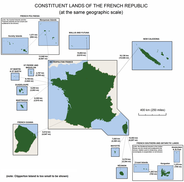
English: The constituent lands of the French Republic |
| दिनांक | |
| स्रोत | अपना कार्य |
| लेखक | Godefroy |
| दूसरे संस्करण |
|

लाइसेंस
मैं, इस कार्य का/की कॉपीराइट धारक, इसे निम्न लाइसेंसों के अंतर्गत प्रकाशित करता/करती हूँ:

|
इस दस्तावेज़ को Free Software Foundation द्वारा प्रकाशित GNU मुक्त प्रलेख लाइसेंस के संस्करण 1.2 या नए (बिना किसी अपरिवर्तनीय अनुभागों और अगले या पिछले आवरण के टेक्स्ट के) के अंतर्गत प्रतिलिपि बनाने, बाँटने और/या बदलने की अनुमति प्रदान की जाती है। इस लाइसेंस की एक प्रतिलिपि GNU मुक्त प्रलेख लाइसेंस नामक अनुभाग में शामिल है। |
| इस फ़ाइल को क्रिएटिव कॉमन्स श्रेय-समानसांझा 3.0 अनरिपोर्टेड लाइसेंस के अंतर्गत लाइसेंस किया गया है। | ||
| ||
| This licensing tag was added to this file as part of the GFDL licensing update. |
आप अपना पसंद का लाइसेंस चुन सकते हैं।
चित्र का इतिहास
फ़ाइलका पुराना अवतरण देखने के लिये दिनांक/समय पर क्लिक करें।
| दिनांक/समय | थंबनेल | आकार | सदस्य | प्रतिक्रिया | |
|---|---|---|---|---|---|
| वर्तमान | 15:47, 7 नवम्बर 2010 | | 3,337 × 3,300 (382 KB) | Rosss | Moved French language map to a separate file |
| 02:58, 6 सितंबर 2010 |  | 3,337 × 3,300 (299 KB) | Hypersite | Correction a few mistakes and showing of forgotten territories. -- Correction de petites erreurs et ajouts de territoires oublié. | |
| 15:52, 17 अप्रैल 2008 |  | 3,337 × 3,300 (382 KB) | Godefroy~commonswiki | {{Information |Description= The constituent lands of the French Republic |Source=self-made |Date= April 17, 2008 |Author= Godefroy |Permission= |other_versions= }} |
चित्र का उपयोग
निम्नलिखित पन्ने इस चित्र से जुडते हैं :
चित्र का वैश्विक उपयोग
इस चित्र का उपयोग इन दूसरे विकियों में किया जाता है:
- an.wikipedia.org पर उपयोग
- ast.wikipedia.org पर उपयोग
- br.wikipedia.org पर उपयोग
- cs.wikipedia.org पर उपयोग
- de.wikipedia.org पर उपयोग
- en.wikipedia.org पर उपयोग
- en.wikibooks.org पर उपयोग
- es.wikipedia.org पर उपयोग
- et.wikipedia.org पर उपयोग
- eu.wikipedia.org पर उपयोग
- fa.wikipedia.org पर उपयोग
- fr.wikipedia.org पर उपयोग
- gl.wikipedia.org पर उपयोग
- he.wikipedia.org पर उपयोग
- hy.wikipedia.org पर उपयोग
- id.wikipedia.org पर उपयोग
- ja.wikipedia.org पर उपयोग
- ka.wikipedia.org पर उपयोग
- km.wikipedia.org पर उपयोग
- lfn.wikipedia.org पर उपयोग
- lld.wikipedia.org पर उपयोग
- lv.wikipedia.org पर उपयोग
- ms.wikipedia.org पर उपयोग
- nn.wikipedia.org पर उपयोग
- no.wikipedia.org पर उपयोग
- pdc.wikipedia.org पर उपयोग
- pt.wikipedia.org पर उपयोग
इस चित्र के वैश्विक उपयोग की अधिक जानकारी देखें।