चित्र:Horst graben.jpg
इससे बड़ा रेसोल्यूशन उपलब्ध नहीं हैं।
Horst_graben.jpg ((271 × 135 पिक्सेल, फ़ाइल का आकार: 41 KB, MIME प्रकार: image/jpeg))
|
|
यह फ़ाइल विकिमेडिया कॉमन्स से है। वहाँ पर इसका विवरण पृष्ठ निम्नोक्त है। कॉमन्स मुक्त लाइसेंसों के अंतर्गत उपलब्ध मीडिया फ़ाइलों का संग्रह है। आप भी इसमें मदद कर सकते हैं। |
सारांश
| विवरण |
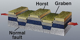
Deutsch: Diagram zur geolog. Struktur von Horsten und Graben.
|
|||
| दिनांक | अज्ञात तारीख | |||
| स्रोत | https://earthquake.usgs.gov/learning/glossary.php?term=graben | |||
| लेखक | U.S. Geological Survey | |||
| अनुमति (इस चित्र का पुनः उपयोग करना) |
|
|||
| दूसरे संस्करण |
Derivative works of this file: |

|
File:Fault-Horst-Graben.svg is a vector version of this file. It should be used in place of this JPG file when not inferior.
File:Horst graben.jpg → File:Fault-Horst-Graben.svg
For more information, see Help:SVG. |
 |
चित्र का इतिहास
फ़ाइलका पुराना अवतरण देखने के लिये दिनांक/समय पर क्लिक करें।
| दिनांक/समय | थंबनेल | आकार | सदस्य | प्रतिक्रिया | |
|---|---|---|---|---|---|
| वर्तमान | 13:29, 6 दिसम्बर 2008 | | 271 × 135 (41 KB) | Woudloper | {{Information |Description=Schematic cross-section through part of the upper crust under extensional tectonics where horsts and grabens formed. |Source= |Date= |Author= |Permission= |other_versions= }} {{PD-USGov-USG |
| 17:48, 13 दिसम्बर 2005 |  | 346 × 260 (19 KB) | Angrense | Diagram of a rift formation. Source: {{PD-USGov-Interior-USGS}} from http://earthquake.usgs.gov/image_glossary/horst.html | |
| 17:36, 25 अगस्त 2005 |  | 346 × 260 (19 KB) | Slawojar | geological structure of horst and graben {{PD-USGov-USGS}} en:Image:Horst graben.jpg Category:Geology |
चित्र का उपयोग
इस चित्र से कोई पन्ने नहीं जुड़ते
चित्र का वैश्विक उपयोग
इस चित्र का उपयोग इन दूसरे विकियों में किया जाता है:
- ast.wikipedia.org पर उपयोग
- az.wikipedia.org पर उपयोग
- bg.wikipedia.org पर उपयोग
- bn.wikipedia.org पर उपयोग
- ca.wikipedia.org पर उपयोग
- da.wikipedia.org पर उपयोग
- en.wikipedia.org पर उपयोग
- en.wikibooks.org पर उपयोग
- eu.wikipedia.org पर उपयोग
- fa.wikipedia.org पर उपयोग
- fi.wikipedia.org पर उपयोग
- fr.wikipedia.org पर उपयोग
- gl.wikipedia.org पर उपयोग
- he.wikipedia.org पर उपयोग
- hy.wikipedia.org पर उपयोग
- id.wikipedia.org पर उपयोग
- it.wikipedia.org पर उपयोग
- it.wikibooks.org पर उपयोग
- it.wikiversity.org पर उपयोग
- ja.wikipedia.org पर उपयोग
- ka.wikipedia.org पर उपयोग
- kk.wikipedia.org पर उपयोग
- ko.wikipedia.org पर उपयोग
- nn.wikipedia.org पर उपयोग
- no.wikipedia.org पर उपयोग
- pl.wiktionary.org पर उपयोग
- pt.wikipedia.org पर उपयोग
- rm.wikipedia.org पर उपयोग
- ru.wikipedia.org पर उपयोग
- sk.wikipedia.org पर उपयोग
- tg.wikipedia.org पर उपयोग
इस चित्र के वैश्विक उपयोग की अधिक जानकारी देखें।