चित्र:ITER participants.png

इस पूर्वावलोकन का आकार: 800 × 351 पिक्सेल। दूसरे रेसोल्यूशन्स: 320 × 140 पिक्सेल | 640 × 281 पिक्सेल | 1,425 × 625 पिक्सेल।
मूल चित्र ((1,425 × 625 पिक्सेल, फ़ाइल का आकार: 37 KB, MIME प्रकार: image/png))
|
|
यह फ़ाइल विकिमेडिया कॉमन्स से है। वहाँ पर इसका विवरण पृष्ठ निम्नोक्त है। कॉमन्स मुक्त लाइसेंसों के अंतर्गत उपलब्ध मीडिया फ़ाइलों का संग्रह है। आप भी इसमें मदद कर सकते हैं। |

|
File:ITER participants.svg is a vector version of this file. It should be used in place of this PNG file when not inferior.
File:ITER participants.png → File:ITER participants.svg
For more information, see Help:SVG. |
 |
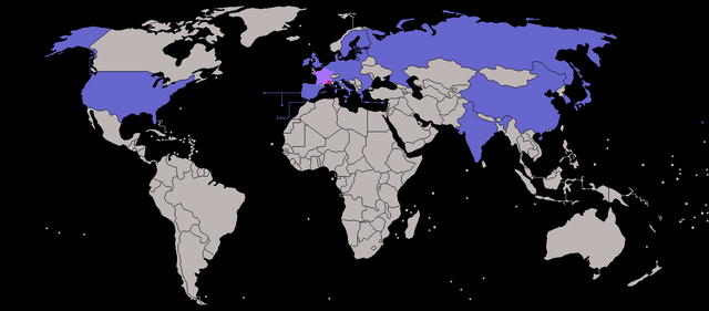
| विवरण | Map of ITER participants - not showing overseas territories of the EU. (France and Cadarache -the host location - highlighted) |
| दिनांक | (UTC) |
| स्रोत | |
| लेखक |
|
| दूसरे संस्करण |
|
| This is a retouched picture, which means that it has been digitally altered from its original version. The original can be viewed here: BlankMap-World-v7.png:
|
मैं, इस कार्य का/की कॉपीराइट धारक, इसे निम्न लाइसेंसों के अंतर्गत प्रकाशित करता/करती हूँ:
| इस फ़ाइल को क्रिएटिव कॉमन्स श्रेय-समानसांझा 3.0 अनरिपोर्टेड लाइसेंस के अंतर्गत लाइसेंस किया गया है। | ||
| ||
| This licensing tag was added to this file as part of the GFDL licensing update. |

|
इस दस्तावेज़ को Free Software Foundation द्वारा प्रकाशित GNU मुक्त प्रलेख लाइसेंस के संस्करण 1.2 या नए (बिना किसी अपरिवर्तनीय अनुभागों और अगले या पिछले आवरण के टेक्स्ट के) के अंतर्गत प्रतिलिपि बनाने, बाँटने और/या बदलने की अनुमति प्रदान की जाती है। इस लाइसेंस की एक प्रतिलिपि GNU मुक्त प्रलेख लाइसेंस नामक अनुभाग में शामिल है। |
आप अपना पसंद का लाइसेंस चुन सकते हैं।
मूल अपलोड लॉग
This image is a derivative work of the following images:
- File:BlankMap-World-v7.png licensed with Cc-by-sa-3.0-migrated, GFDL
- 2010-01-16T07:36:16Z Happenstance 1425x625 (27705 Bytes) fx
- 2010-01-16T07:34:59Z Happenstance 1425x625 (27625 Bytes) darker colour for easier editing in Photoshop (so it doesn't default to grey-scale)
- 2008-07-31T14:49:14Z Avala 1425x625 (49260 Bytes)
- 2008-07-07T08:09:15Z Eynar 1425x625 (49297 Bytes) Updated according to [[:Image:BlankMap-World-v7-Borders.png]]: Fixed connecting pixel between Argentina and Chile. Added Canary Islands, Madeira and Azores (Canary Islands have a total area of 7447 km2, so I put their shape i
- 2008-03-22T21:59:58Z Nightstallion 1425x625 (49095 Bytes) Reverted to version as of 16:40, 13 March 2008
- 2008-03-19T19:33:32Z Patstuart 1425x625 (49058 Bytes) Reverted to version as of 18:25, 11 March 2008 - see [[Image talk:BlankMap-World-v6.png#As stated in reversion]]
- 2008-03-13T16:40:26Z Nightstallion 1425x625 (49095 Bytes) no, there does not have to be; upload a variant if you wish, but please this image as it is (or start a discussion somewhere BEFORE reverting)
- 2008-03-11T18:25:34Z Avala 1425x625 (49058 Bytes) there must be international consensus to show this as a final border. shading would be the best solution or stripes
- 2008-02-25T20:16:26Z Nightstallion 1425x625 (49095 Bytes) Reverted to version as of :, 0 <>
- 2008-02-25T19:59:41Z Cp6 1425x625 (49058 Bytes) Reverted to version as of :, 0 <>
- 2008-02-25T11:19:17Z Nightstallion 1425x625 (49095 Bytes) Reverted to version as of :, 0 <>
- 2008-02-24T13:45:43Z Cp6 1425x625 (49058 Bytes) Reverted to version as of :, 0 <>
- 2008-02-24T12:49:24Z Nightstallion 1425x625 (49095 Bytes) Reverted to version as of :, 0 <>
- 2008-02-23T22:30:46Z Cp6 1425x625 (49058 Bytes) No OVERWRITING, look disc
- 2008-02-23T10:51:19Z Nightstallion 1425x625 (49095 Bytes) Reverted to version as of :, 0 <>
- 2008-02-22T22:15:10Z Cp6 1425x625 (49058 Bytes) It isn't internationally recognized, look [[Image:Kosovo relations.png]]
- 2008-02-18T23:31:04Z Hoshie 1425x625 (49095 Bytes) Added Kosovo since it has been internationally recognized.
- 2007-11-05T07:00:15Z Wiz9999 1425x625 (49058 Bytes) Corrected proportions to correlate with BlankMap-World.png, & Updated in accordance with v5 and v6
- 2007-02-24T18:51:20Z Wiz9999 1357x628 (57817 Bytes) Updated in accordance with v6
- 2007-01-28T05:20:13Z Wiz9999 1357x628 (57818 Bytes) Updated in accordance with v5
- 2006-10-21T18:41:25Z Wiz9999 1357x628 (57795 Bytes) == Summary == Blank world map, based on [[:Image:BlankMap-World-v5.png]], but including all dependencies (i.e. all territories with [[w:ISO 3166-1|ISO 3166-1]] codes) For sovereign countries which are depicted by a dot, the
Uploaded with derivativeFX
चित्र का इतिहास
फ़ाइलका पुराना अवतरण देखने के लिये दिनांक/समय पर क्लिक करें।
| दिनांक/समय | थंबनेल | आकार | सदस्य | प्रतिक्रिया | |
|---|---|---|---|---|---|
| वर्तमान | 15:34, 31 जुलाई 2013 | | 1,425 × 625 (37 KB) | SenseiAC | Croatie-UE-2013 Croatia-EU-2013 |
| 15:29, 31 जुलाई 2013 |  | 1,425 × 625 (37 KB) | SenseiAC | Croatie-UE-2013 Croatia-EU-2013 | |
| 18:43, 6 जनवरी 2012 |  | 1,425 × 625 (17 KB) | Quibik | Added transparency and converted color mode to indexed. | |
| 20:04, 28 फ़रवरी 2010 |  | 1,425 × 625 (32 KB) | JLogan | increased size of host city dot | |
| 19:58, 28 फ़रवरी 2010 |  | 1,425 × 625 (32 KB) | JLogan | m corrections to europe | |
| 19:46, 28 फ़रवरी 2010 |  | 1,425 × 625 (32 KB) | JLogan | {{Information |Description=Map of ITER participants - not showing overseas territories of the EU. |Source=*File:BlankMap-World-v7.png |Date=2010-02-28 19:43 (UTC) |Author=*File:BlankMap-World-v7.png: various, see log below *derivative work: [[ |
चित्र का उपयोग
निम्नलिखित पन्ने इस चित्र से जुडते हैं :
चित्र का वैश्विक उपयोग
इस चित्र का उपयोग इन दूसरे विकियों में किया जाता है: