चित्र:IranOMC.png
इस पूर्वावलोकन का आकार: 708 × 600 पिक्सेल। दूसरे रेसोल्यूशन्स: 283 × 240 पिक्सेल | 567 × 480 पिक्सेल | 930 × 788 पिक्सेल।
मूल चित्र ((930 × 788 पिक्सेल, फ़ाइल का आकार: 53 KB, MIME प्रकार: image/png))
|
|
यह फ़ाइल विकिमेडिया कॉमन्स से है। वहाँ पर इसका विवरण पृष्ठ निम्नोक्त है। कॉमन्स मुक्त लाइसेंसों के अंतर्गत उपलब्ध मीडिया फ़ाइलों का संग्रह है। आप भी इसमें मदद कर सकते हैं। |
सारांश
| विवरण |
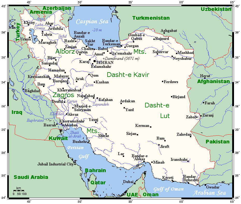
English: A map showing Iran's cities and main towns. This map's source is here, with the uploader's modifications, and the GMT homepage says that the tools are released under the GNU General Public License. |
| दिनांक | ६ अगस्त २००७ (original upload date) |
| स्रोत | Transferred from en.wikipedia to Commons. |
| लेखक | अंग्रेज़ी विकिपीडिया पर Kelisi |
लाइसेंस
Kelisi from en.wikipedia.org, इस कार्य के कॉपीराइट धारक, इसे निम्न लाइसेंस के अंतर्गत प्रकाशित करते हैं:
| इस फ़ाइल को क्रिएटिव कॉमन्स श्रेय-समानसांझा 3.0 अनरिपोर्टेड लाइसेंस के अंतर्गत लाइसेंस किया गया है। Subject to disclaimers. | ||
| श्रेय: Kelisi from en.wikipedia.org | ||
| ||
| This licensing tag was added to this file as part of the GFDL licensing update. |

|
इस दस्तावेज़ को Free Software Foundation द्वारा प्रकाशित GNU मुक्त प्रलेख लाइसेंस के संस्करण 1.2 या नए (बिना किसी अपरिवर्तनीय अनुभागों और अगले या पिछले आवरण के टेक्स्ट के) के अंतर्गत प्रतिलिपि बनाने, बाँटने और/या बदलने की अनुमति प्रदान की जाती है। इस लाइसेंस की एक प्रतिलिपि GNU मुक्त प्रलेख लाइसेंस नामक अनुभाग में शामिल है। Subject to disclaimers. |
मूल अपलोड लॉग
The original description page was here. All following user names refer to en.wikipedia.
- 2007-08-06 16:05 Kelisi 930×788× (54211 bytes) == Summary == A map showing Iran's cities and main towns. This map's source is [http://www.aquarius.ifm-geomar.de/ here], with the uploader's modifications, and the [http://gmt.soest.hawaii.edu/ GMT homepage] says that the tools are released under the GNU
चित्र का इतिहास
फ़ाइलका पुराना अवतरण देखने के लिये दिनांक/समय पर क्लिक करें।
| दिनांक/समय | थंबनेल | आकार | सदस्य | प्रतिक्रिया | |
|---|---|---|---|---|---|
| वर्तमान | 05:59, 27 नवम्बर 2011 | | 930 × 788 (53 KB) | Urdangaray | {{Information |Description={{en|A map showing Iran's cities and main towns. This map's source is [http://www.aquarius.ifm-geomar.de/ here], with the uploader's modifications, and the [http://gmt.soest.hawaii.edu/ GMT homepage] says that the tools are rele |
चित्र का उपयोग
निम्नलिखित पन्ने इस चित्र से जुडते हैं :
चित्र का वैश्विक उपयोग
इस चित्र का उपयोग इन दूसरे विकियों में किया जाता है:
- ast.wikipedia.org पर उपयोग
- en.wikipedia.org पर उपयोग
- es.wikipedia.org पर उपयोग
- eu.wikipedia.org पर उपयोग
- fa.wikipedia.org पर उपयोग
- fr.wikipedia.org पर उपयोग
- id.wikipedia.org पर उपयोग
- mg.wikipedia.org पर उपयोग
- ms.wikipedia.org पर उपयोग
- my.wikipedia.org पर उपयोग
- nn.wikipedia.org पर उपयोग
- se.wikipedia.org पर उपयोग
- sl.wikipedia.org पर उपयोग
- smn.wikipedia.org पर उपयोग
- tg.wikipedia.org पर उपयोग
- uk.wikipedia.org पर उपयोग
- zh.wikipedia.org पर उपयोग