चित्र:MadakasiraFort-Top-View.jpg

इस पूर्वावलोकन का आकार: 800 × 480 पिक्सेल। दूसरे रेसोल्यूशन्स: 320 × 192 पिक्सेल | 1,024 × 614 पिक्सेल | 1,280 × 767 पिक्सेल | 3,196 × 1,916 पिक्सेल।
मूल चित्र ((3,196 × 1,916 पिक्सेल, फ़ाइल का आकार: 6.09 MB, MIME प्रकार: image/jpeg))
|
|
यह फ़ाइल विकिमेडिया कॉमन्स से है। वहाँ पर इसका विवरण पृष्ठ निम्नोक्त है। कॉमन्स मुक्त लाइसेंसों के अंतर्गत उपलब्ध मीडिया फ़ाइलों का संग्रह है। आप भी इसमें मदद कर सकते हैं। |
सारांश
| विवरण |
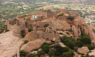
English: Madakasira Hill Fort is called as SIMHAGIRI Hill Fort because the hill from one side looks like a sleeping lion.The 2936 feet msl highly Fortified Hill is in Anantapur Dist of AndhraPradesh which was once, one of the stronghold of Vijayanagara Kingdom.Under Vijayanagara, the Madakasira was fortified strongly by the chiefs of Sira,especially under Hira Vdaiyar. But after the fall of Vijayanagara, it was taken by 'the Sultanate of Bijapur' but then left it back to him along with forts of Ratnagiri. In 1728 the Marathas captured Madakasira, and in 1741 the Ratnagiri Fort was taken by Morari Rao (Army General,Maratha) and imposed tribute of 8000/-. In 1762 Haidar Ali of Mysore took Madakasira, but his troops were ejected two years later by Morari Rao. Haidar seized it again in 1776 and demanded a tribute of 15000/-. On failing upon this, he send the chief and his five sons as prisoners to Seringapatam. In 1799 the country fell under British rule.
The town is now a fairly important market center. The Fort entrance, two main large bastions, and parts of the forts still remains in the city apart from the Fortification in the Hill.They are under ASI. Parts of the film 'Krishna Gaadi Veera Prema Gaadha' was shot in this fort.
|
||
| दिनांक | |||
| स्रोत | अपना कार्य | ||
| लेखक | Gopakumar V R |
| कैमरा स्थान | | यह और अन्य आसपास की छवियों यहां पर देखें: ओपन स्ट्रीट मैप |
|---|
लाइसेंस
मैं, इस कार्य का/की कॉपीराइट धारक, इसे निम्न लाइसेंस के अंतर्गत प्रकाशित करता/करती हूँ:
इस फ़ाइल को क्रिएटिव कॉमन्स श्रेय-समानसांझा 4.0 अंतर्राष्ट्रीय लाइसेंस के अंतर्गत लाइसेंस किया गया है।
- आप खुलकर:
- बाँट सकते हैं – रचना की प्रतिलिपि बना सकते हैं, बाँँट सकते हैं और संचारित कर सकते हैं
- रीमिक्स कर सकते हैं – कार्य को अनुकूलित कर सकते हैं
- निम्नलिखित शर्तों के अंतर्गत:
- श्रेय – यह अनिवार्य है कि आप यथोचित श्रेय प्रदान करें, लाइसेंस की कड़ी प्रदान करें, और अगर कोई बदलाव हुए हों तो उन्हें इंगित करें। आप ऐसा किसी भी उचित तरीके से कर सकते हैं, लेकिन किसी भी तरह उससे यह नहीं संकेत नहीं किया जाना चाहिए कि लाइसेंसधारी द्वारा आपको अथवा आपके इस प्रयोग का समर्थन किया जा रहा हो।
- समानसांझा – अगर आप इस रचना में कोई बदलाव करते हैं या इसपर आधारित कुछ रचित करते हैं तो आप अपने योगदान को सिर्फ इसी या इसके सामान किसी लाइसेंस के अंतर्गत बाँट सकते हैं।

|
इस चित्र को विकि लव्स मॉन्युमेंट्स 2018 के अंतर्गत अपलोड किया गया था।
|
 |
चित्र का इतिहास
फ़ाइलका पुराना अवतरण देखने के लिये दिनांक/समय पर क्लिक करें।
| दिनांक/समय | थंबनेल | आकार | सदस्य | प्रतिक्रिया | |
|---|---|---|---|---|---|
| वर्तमान | 17:34, 3 सितंबर 2018 | | 3,196 × 1,916 (6.09 MB) | Gopakumar V R | User created page with UploadWizard |
चित्र का उपयोग
निम्नलिखित पन्ने इस चित्र से जुडते हैं :
चित्र का वैश्विक उपयोग
इस चित्र का उपयोग इन दूसरे विकियों में किया जाता है:
- azb.wikipedia.org पर उपयोग
- en.wikipedia.org पर उपयोग
- pa.wikipedia.org पर उपयोग
- ta.wikipedia.org पर उपयोग
- te.wikipedia.org पर उपयोग
- www.wikidata.org पर उपयोग