चित्र:Map-of-southeast-asia 1000 - 1100 CE.png

इस पूर्वावलोकन का आकार: 426 × 600 पिक्सेल। दूसरे रेसोल्यूशन्स: 170 × 240 पिक्सेल | 341 × 480 पिक्सेल | 791 × 1,114 पिक्सेल।
मूल चित्र ((791 × 1,114 पिक्सेल, फ़ाइल का आकार: 162 KB, MIME प्रकार: image/png))
|
|
यह फ़ाइल विकिमेडिया कॉमन्स से है। वहाँ पर इसका विवरण पृष्ठ निम्नोक्त है। कॉमन्स मुक्त लाइसेंसों के अंतर्गत उपलब्ध मीडिया फ़ाइलों का संग्रह है। आप भी इसमें मदद कर सकते हैं। |
3ㅐㅛㅑ혀댜해ㅔㅎ재ㅗ3ㅐㅗ39햐3호9ㅍ뎌ㅗㅑㅑㄷ
सारांश
| विवरण |
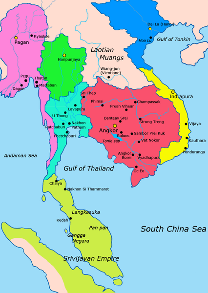
English: Map of Mainland Southeast Asia circa 1000 - 1100 CE, showing Khmer Empire in red, Lavo kingdom/Dvaravati in light blue, Haripunjaya in green, Champa in yellow, Dai Viet in blue, Kingdom of Pagan in pink, Srivijaya in lime and surrounding states.
sources http://ecaimaps.berkeley.edu/animations/2003_03_khmer_animation.swf http://www.britannica.com/EBchecked/media/3395/Khmer-empire-1200 Atlas of world history, Patrick Karl O'brien Societies, Networks, and Transitions: A Global History, Volume B. Craig A.Lockard http://upload.wikimedia.org/wikipedia/commons/thumb/4/45/Srivijaya_Empire.svg/2000px-Srivijaya_Empire.svg.png File:DvaravatiMapThailand.png http://upload.wikimedia.org/wikipedia/commons/e/eb/Thailand_2002_CIA_map.jpg |
| दिनांक | |
| स्रोत | अपना कार्य |
| लेखक | Javierfv1212 |
लाइसेंस
मैं, इस कार्य का/की कॉपीराइट धारक, इसे निम्न लाइसेंस के अंतर्गत प्रकाशित करता/करती हूँ:
| इस फ़ाइल को क्रिएटिव कॉमन्स CC0 1.0 वैश्विक सार्वजनिक डोमेन समर्पण के अंतर्गत उपलब्ध कराया गया है। | |
| कार्य को इस आलेख से संबद्ध करने वाले व्यक्ति ने पूरे विश्व में कॉपीराइट कानूनों के अंतर्गत कार्य पर कानून की अनुमोदित सीमा तक सभी संबंधित अधिकारों समेत अपने सभी अधिकार त्यागकर इसे सार्वजनिक डोमेन को समर्पित किया है। आप बिना अनुमति के कार्य की प्रतियाँ बना सकते हैं, इसे बदल और पुनः वितरित कर सकते हैं, और प्रदर्शित कर सकते हैं, वाणिज्यिक उद्देश्यों से भी।
|

|
This historical map image could be re-created using vector graphics as an SVG file. This has several advantages; see Commons:Media for cleanup for more information. If an SVG form of this image is available, please upload it and afterwards replace this template with
{{vector version available|new image name}}.
It is recommended to name the SVG file “Map-of-southeast-asia 1000 - 1100 CE.svg”—then the template Vector version available (or Vva) does not need the new image name parameter. |
चित्र का इतिहास
फ़ाइलका पुराना अवतरण देखने के लिये दिनांक/समय पर क्लिक करें।
| दिनांक/समय | थंबनेल | आकार | सदस्य | प्रतिक्रिया | |
|---|---|---|---|---|---|
| वर्तमान | 21:57, 19 जुलाई 2011 | | 791 × 1,114 (162 KB) | Ras67 | cropped |
| 02:18, 28 मार्च 2011 |  | 800 × 1,125 (224 KB) | Javierfv1212 | {{Information |Description ={{en|1=Map of Southeast Asia circa 1000 - 1100 CE, showing Khmer Empire in red, Lavo kingdom/Dvaravati in light blue, Haripunjaya in green, Champa in yellow and surrounding states. sources http://ecaimaps.berkeley.edu/an |
चित्र का उपयोग
निम्नलिखित पन्ने इस चित्र से जुडते हैं :
चित्र का वैश्विक उपयोग
इस चित्र का उपयोग इन दूसरे विकियों में किया जाता है:
- af.wikipedia.org पर उपयोग
- ar.wikipedia.org पर उपयोग
- ast.wikipedia.org पर उपयोग
- ba.wikipedia.org पर उपयोग
- bn.wikipedia.org पर उपयोग
- ca.wikipedia.org पर उपयोग
- de.wikipedia.org पर उपयोग
- el.wikipedia.org पर उपयोग
- en.wikipedia.org पर उपयोग
- eu.wikipedia.org पर उपयोग
- fr.wikipedia.org पर उपयोग
- gl.wikipedia.org पर उपयोग
- id.wikipedia.org पर उपयोग
- incubator.wikimedia.org पर उपयोग
- it.wikipedia.org पर उपयोग
- ja.wikipedia.org पर उपयोग
- km.wikipedia.org पर उपयोग
- ko.wikipedia.org पर उपयोग
- lfn.wikipedia.org पर उपयोग
- lt.wikipedia.org पर उपयोग
- ml.wikipedia.org पर उपयोग
- mn.wikipedia.org पर उपयोग
- no.wikipedia.org पर उपयोग
- pt.wikipedia.org पर उपयोग
- ru.wikipedia.org पर उपयोग
- sh.wikipedia.org पर उपयोग
- sl.wikipedia.org पर उपयोग
- th.wikipedia.org पर उपयोग
- uk.wikipedia.org पर उपयोग
इस चित्र के वैश्विक उपयोग की अधिक जानकारी देखें।