चित्र:Map Bolivia territorial loss-en.svg

पूर्वावलोकन PNG का आकार SVG फ़ाइल: 375 × 355 पिक्सेल दूसरे रेसोल्यूशन्स: 254 × 240 पिक्सेल | 507 × 480 पिक्सेल | 811 × 768 पिक्सेल | 1,082 × 1,024 पिक्सेल | 2,163 × 2,048 पिक्सेल।
मूल चित्र (SVG फ़ाइल, साधारणतः 375 × 355 पिक्सेल, फ़ाइल का आकार: 78 KB)
|
|
यह फ़ाइल विकिमेडिया कॉमन्स से है। वहाँ पर इसका विवरण पृष्ठ निम्नोक्त है। कॉमन्स मुक्त लाइसेंसों के अंतर्गत उपलब्ध मीडिया फ़ाइलों का संग्रह है। आप भी इसमें मदद कर सकते हैं। |
| विवरण |
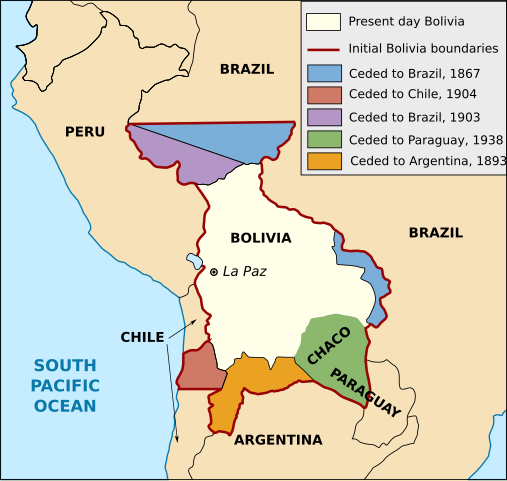
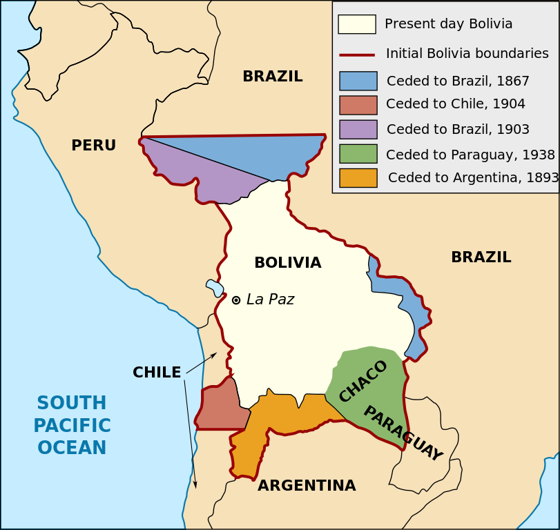
English: Territorial loss map of Bolivia |
| दिनांक | (UTC) |
| स्रोत | |
| लेखक |
|
| दूसरे संस्करण |
[]
Derivative works of this file: |


This work is in the public domain in the United States because it is a work prepared by an officer or employee of the United States Government as part of that person’s official duties under the terms of Title 17, Chapter 1, Section 105 of the US Code.
Note: This only applies to original works of the Federal Government and not to the work of any individual U.S. state, territory, commonwealth, county, municipality, or any other subdivision. This template also does not apply to postage stamp designs published by the United States Postal Service since 1978. (See § 313.6(C)(1) of Compendium of U.S. Copyright Office Practices). It also does not apply to certain US coins; see The US Mint Terms of Use.
|
 | |
| इस फ़ाइल को कॉपीराइट कानूनों के अंतर्गत सभी संबंधित अधिकारों समेत ज्ञात सीमाओं से मुक्त पहचाना गया है। | ||
चित्र का इतिहास
फ़ाइलका पुराना अवतरण देखने के लिये दिनांक/समय पर क्लिक करें।
| दिनांक/समय | थंबनेल | आकार | सदस्य | प्रतिक्रिया | |
|---|---|---|---|---|---|
| वर्तमान | 16:19, 1 जनवरी 2020 | | 375 × 355 (78 KB) | Janitoalevic | Added territory ceded to Argentina |
| 18:48, 12 दिसम्बर 2013 |  | 375 × 355 (68 KB) | Pethrus | Fixed ocean name | |
| 16:07, 4 मई 2010 |  | 375 × 355 (68 KB) | Naturals | The territory of Paraguay was reversed with the territory of Brazil | |
| 19:06, 3 मई 2010 |  | 375 × 355 (69 KB) | Pethrus | Paraguay border fixed | |
| 19:02, 3 मई 2010 |  | 375 × 355 (69 KB) | Pethrus | Fixed bugs | |
| 18:56, 3 मई 2010 |  | 375 × 355 (79 KB) | Pethrus | Inkscape bugs fixed | |
| 18:53, 3 मई 2010 |  | 375 × 355 (81 KB) | Pethrus | {{Information |Description={{en|Territorial loss map of Bolivia}} |Source=*File:Bolivia_territorial_loss_map_LOC.jpg |Date=2010-05-03 18:51 (UTC) |Author=*File:Bolivia_territorial_loss_map_LOC.jpg: Library of Congress Country Study on Bolivia |
चित्र का उपयोग
निम्नलिखित पन्ने इस चित्र से जुडते हैं :
चित्र का वैश्विक उपयोग
इस चित्र का उपयोग इन दूसरे विकियों में किया जाता है:
- az.wikipedia.org पर उपयोग
- ca.wikipedia.org पर उपयोग
- cs.wikipedia.org पर उपयोग
- da.wikipedia.org पर उपयोग
- de.wikipedia.org पर उपयोग
- en.wikipedia.org पर उपयोग
- eu.wikipedia.org पर उपयोग
- fi.wikipedia.org पर उपयोग
- fr.wikipedia.org पर उपयोग
- hi.wiktionary.org पर उपयोग
- id.wikipedia.org पर उपयोग
- it.wikipedia.org पर उपयोग
- ja.wikipedia.org पर उपयोग
- ka.wikipedia.org पर उपयोग
- ko.wikipedia.org पर उपयोग
- lt.wikipedia.org पर उपयोग
- nl.wikipedia.org पर उपयोग
- pl.wikipedia.org पर उपयोग
- pt.wikipedia.org पर उपयोग
- sat.wikipedia.org पर उपयोग
- sd.wikipedia.org पर उपयोग
- sk.wikipedia.org पर उपयोग
- te.wikipedia.org पर उपयोग
- zh.wikipedia.org पर उपयोग