चित्र:Map of Alabama NA.png

इस पूर्वावलोकन का आकार: 776 × 600 पिक्सेल। दूसरे रेसोल्यूशन्स: 311 × 240 पिक्सेल | 621 × 480 पिक्सेल | 994 × 768 पिक्सेल | 1,280 × 989 पिक्सेल | 2,122 × 1,640 पिक्सेल।
मूल चित्र ((2,122 × 1,640 पिक्सेल, फ़ाइल का आकार: 1.61 MB, MIME प्रकार: image/png))
|
|
यह फ़ाइल विकिमेडिया कॉमन्स से है। वहाँ पर इसका विवरण पृष्ठ निम्नोक्त है। कॉमन्स मुक्त लाइसेंसों के अंतर्गत उपलब्ध मीडिया फ़ाइलों का संग्रह है। आप भी इसमें मदद कर सकते हैं। |
सारांश
| विवरण |
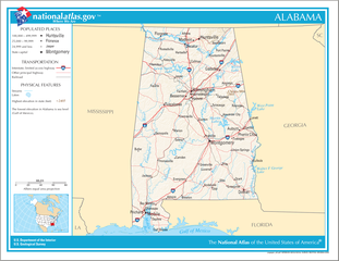
English: Map of the U.S. state of Alabama, with full legend area, copied from the National Atlas of the United States in high resolution form (1.61 megabytes). |
| दिनांक | (uploaded on १४ अगस्त २००६) |
| स्रोत | |
| लेखक | National Atlas of the United States (uploaded by User:Huebi) |
| दूसरे संस्करण |
The map has some related variations:
|
लाइसेंस
This map was obtained from an edition of the National Atlas of the United States. Like almost all works of the U.S. federal government, works from the National Atlas are in the public domain in the United States.
Online access: NationalAtlas.gov | 1970 print edition: Library of Congress, Perry-Castañeda Library
|
चित्र का इतिहास
फ़ाइलका पुराना अवतरण देखने के लिये दिनांक/समय पर क्लिक करें।
| दिनांक/समय | थंबनेल | आकार | सदस्य | प्रतिक्रिया | |
|---|---|---|---|---|---|
| वर्तमान | 20:08, 14 अगस्त 2006 | | 2,122 × 1,640 (1.61 MB) | Huebi~commonswiki | {{Information| |Description=Map of Alabama |Source=[http://www.nationalatlas.gov National Atlas] }} Category:Maps of the United States Category:Maps of Alabama {{PD-USGov-Atlas}} |
चित्र का उपयोग
निम्नलिखित पन्ने इस चित्र से जुडते हैं :
चित्र का वैश्विक उपयोग
इस चित्र का उपयोग इन दूसरे विकियों में किया जाता है:
- als.wikipedia.org पर उपयोग
- bs.wikipedia.org पर उपयोग
- ca.wikipedia.org पर उपयोग
- de.wikipedia.org पर उपयोग
- en.wikipedia.org पर उपयोग
- hr.wiktionary.org पर उपयोग
- hsb.wikipedia.org पर उपयोग
- hu.wikipedia.org पर उपयोग
- ilo.wikipedia.org पर उपयोग
- it.wikipedia.org पर उपयोग
- ja.wikipedia.org पर उपयोग
- ko.wikipedia.org पर उपयोग
- no.wikipedia.org पर उपयोग
- or.wikipedia.org पर उपयोग
- simple.wikipedia.org पर उपयोग
- si.wikipedia.org पर उपयोग
- uz.wikipedia.org पर उपयोग
- zea.wikipedia.org पर उपयोग