चित्र:Map of Christmas Island 1976.jpg

इस पूर्वावलोकन का आकार: 657 × 600 पिक्सेल। दूसरे रेसोल्यूशन्स: 263 × 240 पिक्सेल | 526 × 480 पिक्सेल | 839 × 766 पिक्सेल।
मूल चित्र ((839 × 766 पिक्सेल, फ़ाइल का आकार: 692 KB, MIME प्रकार: image/jpeg))
|
|
यह फ़ाइल विकिमेडिया कॉमन्स से है। वहाँ पर इसका विवरण पृष्ठ निम्नोक्त है। कॉमन्स मुक्त लाइसेंसों के अंतर्गत उपलब्ध मीडिया फ़ाइलों का संग्रह है। आप भी इसमें मदद कर सकते हैं। |
सारांश
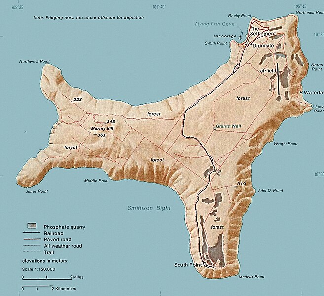
| विवरण | Map of Christmas. This map was produced by the U.S. Central Intelligence Agency, unless otherwise indicated. Maps dated 1976 were taken from The Indian Ocean Atlas, published by the Central Intelligence Agency. |
| दिनांक | dated 1976 |
| स्रोत | http://www.lib.utexas.edu/maps/islands_oceans_poles/christmas_island_76.jpg |
| लेखक | अनजान |
लाइसेंस
| This image is a work of a Central Intelligence Agency employee, taken or made as part of that person's official duties. As a Work of the United States Government, this image or media is in the public domain in the United States.
|

|
चित्र का इतिहास
फ़ाइलका पुराना अवतरण देखने के लिये दिनांक/समय पर क्लिक करें।
| दिनांक/समय | थंबनेल | आकार | सदस्य | प्रतिक्रिया | |
|---|---|---|---|---|---|
| वर्तमान | 15:24, 3 फ़रवरी 2018 | | 839 × 766 (692 KB) | Hohum | Cleanup |
| 20:33, 18 दिसम्बर 2010 |  | 839 × 766 (365 KB) | Ras67 | cropped | |
| 19:15, 11 फ़रवरी 2006 |  | 839 × 774 (128 KB) | Walden69 | Map of Christmas. This map were produced by the U.S. Central Intelligence Agency, unless otherwise indicated. Maps dated 1976 were taken from The Indian Ocean Atlas, published by the Central Intelligence Agency. {{PD-USGov-CIA}} |
चित्र का उपयोग
निम्नलिखित पन्ने इस चित्र से जुडते हैं :
चित्र का वैश्विक उपयोग
इस चित्र का उपयोग इन दूसरे विकियों में किया जाता है:
- ar.wikipedia.org पर उपयोग
- arz.wikipedia.org पर उपयोग
- ast.wikipedia.org पर उपयोग
- bs.wikipedia.org पर उपयोग
- ca.wikipedia.org पर उपयोग
- ceb.wikipedia.org पर उपयोग
- de.wikipedia.org पर उपयोग
- el.wikipedia.org पर उपयोग
- en.wikipedia.org पर उपयोग
- Christmas Island
- Christmas Island Airport
- Christmas imperial pigeon
- Postage stamps and postal history of Christmas Island
- List of butterflies of Australia
- Murray Hill, Christmas Island
- List of moths of Christmas Island
- Christmas Island Phosphate Co.'s Railway
- Christmas Island flying fox
- Wildlife of Christmas Island
- en.wikiversity.org पर उपयोग
- en.wikivoyage.org पर उपयोग
- eo.wikipedia.org पर उपयोग
- es.wikipedia.org पर उपयोग
- et.wikipedia.org पर उपयोग
- eu.wikipedia.org पर उपयोग
- fa.wikipedia.org पर उपयोग
- fr.wikipedia.org पर उपयोग
- gl.wikipedia.org पर उपयोग
- gu.wikipedia.org पर उपयोग
- hi.wiktionary.org पर उपयोग
- hu.wikipedia.org पर उपयोग
- it.wikipedia.org पर उपयोग
- ja.wikipedia.org पर उपयोग
- kk.wikipedia.org पर उपयोग
- la.wikipedia.org पर उपयोग
- lld.wikipedia.org पर उपयोग
- ml.wikipedia.org पर उपयोग
- ms.wikipedia.org पर उपयोग
- nn.wikipedia.org पर उपयोग
इस चित्र के वैश्विक उपयोग की अधिक जानकारी देखें।