चित्र:Map of Sealand with territorial waters.png

मूल चित्र ((1,174 × 1,200 पिक्सेल, फ़ाइल का आकार: 55 KB, MIME प्रकार: image/png))
|
|
यह फ़ाइल विकिमेडिया कॉमन्स से है। वहाँ पर इसका विवरण पृष्ठ निम्नोक्त है। कॉमन्स मुक्त लाइसेंसों के अंतर्गत उपलब्ध मीडिया फ़ाइलों का संग्रह है। आप भी इसमें मदद कर सकते हैं। |
| Description |
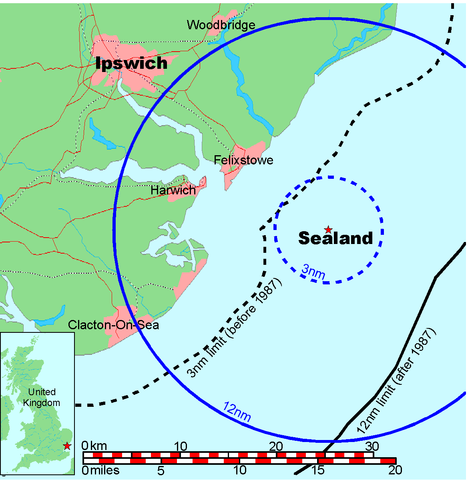
Map of Sealand This is a map of the coast of England near Ipswich, showing the location of Sealand. The boundaries of the territorial water of the United Kingdom are also drawn, both the 3 nautical mile limit (5.556km) before 1987 and the 12nm limit (22.22km) after 1987. The same radii are also given around Sealand. Note that these boundaries are derived based on the circular distance from the coastline, and not copied from official maps. This map is not suitable for navigation or for determining the boundaries of the UK territorial waters for legal or other purposes.
|
|||||||||
| रचियता |
Map generated by DEMIS World Map Server and edited by Chris 73 |
|||||||||
| अनुमति (इस चित्र का पुनः उपयोग करना) |
|
|||||||||
| Geotemporal data | ||||||||||
| Bounding box |
|
|||||||||
| Georeferencing | ||||||||||

चित्र का इतिहास
फ़ाइलका पुराना अवतरण देखने के लिये दिनांक/समय पर क्लिक करें।
| दिनांक/समय | थंबनेल | आकार | सदस्य | प्रतिक्रिया | |
|---|---|---|---|---|---|
| वर्तमान | 19:41, 9 जुलाई 2006 | | 1,174 × 1,200 (55 KB) | Chris 73 | update |
| 10:00, 26 जनवरी 2005 |  | 1,024 × 1,046 (50 KB) | Chris 73 |
चित्र का उपयोग
निम्नलिखित पन्ने इस चित्र से जुडते हैं :
चित्र का वैश्विक उपयोग
इस चित्र का उपयोग इन दूसरे विकियों में किया जाता है:
- af.wikipedia.org पर उपयोग
- be-tarask.wikipedia.org पर उपयोग
- be.wikipedia.org पर उपयोग
- de.wikipedia.org पर उपयोग
- en.wikipedia.org पर उपयोग
- eo.wikipedia.org पर उपयोग
- fy.wikipedia.org पर उपयोग
- hr.wikipedia.org पर उपयोग
- hu.wikipedia.org पर उपयोग
- ko.wikipedia.org पर उपयोग
- lb.wikipedia.org पर उपयोग
- os.wikipedia.org पर उपयोग
- pl.wikipedia.org पर उपयोग
- wa.wikipedia.org पर उपयोग