चित्र:Nagaland locator map.svg

पूर्वावलोकन PNG का आकार SVG फ़ाइल: 734 × 600 पिक्सेल दूसरे रेसोल्यूशन्स: 294 × 240 पिक्सेल | 587 × 480 पिक्सेल | 940 × 768 पिक्सेल | 1,253 × 1,024 पिक्सेल | 2,506 × 2,048 पिक्सेल | 2,393 × 1,956 पिक्सेल।
मूल चित्र (SVG फ़ाइल, साधारणतः 2,393 × 1,956 पिक्सेल, फ़ाइल का आकार: 277 KB)
|
|
यह फ़ाइल विकिमेडिया कॉमन्स से है। वहाँ पर इसका विवरण पृष्ठ निम्नोक्त है। कॉमन्स मुक्त लाइसेंसों के अंतर्गत उपलब्ध मीडिया फ़ाइलों का संग्रह है। आप भी इसमें मदद कर सकते हैं। |
| शीर्षक |
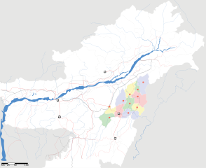
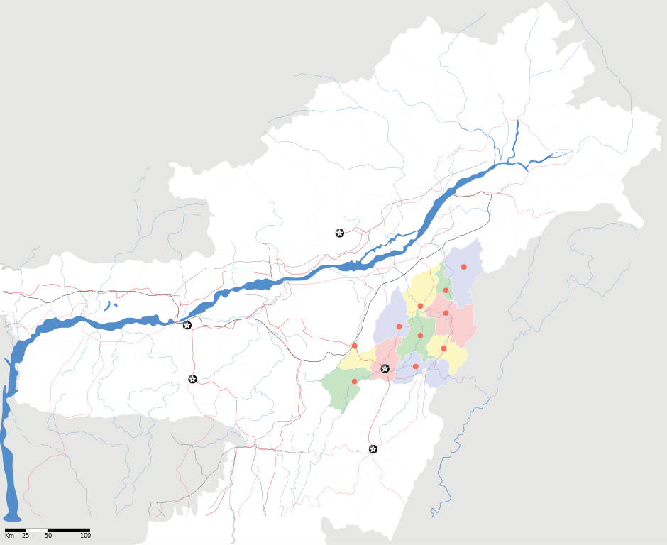
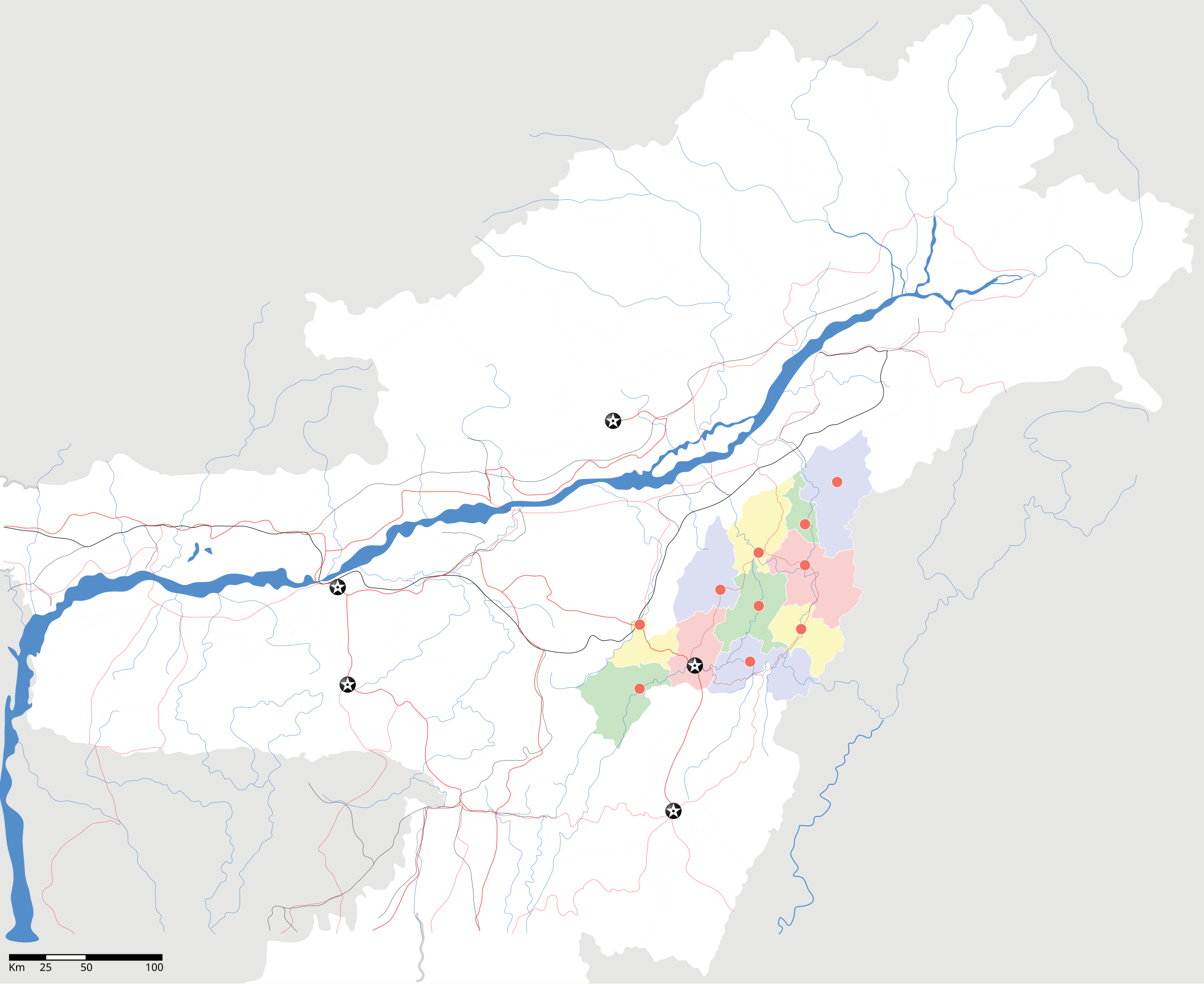
Nagaland locator Map |
| Description |
Map of w:Nagaland with road and rail lines. Equirectangular projection. Geographic limits of the map: top=29.49, bottom=23.74, left=89.61, right=97.52. |
| दिनांक | |
| स्रोत |
अपना कार्य |
| रचियता | |
| अनुमति (इस चित्र का पुनः उपयोग करना) |
मैं, इस कार्य का/की कॉपीराइट धारक, इसे निम्न लाइसेंस के अंतर्गत प्रकाशित करता/करती हूँ: इस फ़ाइल को क्रिएटिव कॉमन्स श्रेय-समानसांझा 3.0 अनरिपोर्टेड लाइसेंस के अंतर्गत लाइसेंस किया गया है।
|
| Geotemporal data | |
| Date depicted | second half of 20 century और 21 century |
| Georeferencing | If inappropriate please set warp_status = skip to hide. |
| Archival data | |
| नोट्स | Part of WikiProject India Maps |
चित्र का इतिहास
फ़ाइलका पुराना अवतरण देखने के लिये दिनांक/समय पर क्लिक करें।
| दिनांक/समय | थंबनेल | आकार | सदस्य | प्रतिक्रिया | |
|---|---|---|---|---|---|
| वर्तमान | 12:05, 17 अप्रैल 2007 | | 2,393 × 1,956 (277 KB) | Planemad | not displaying, reupload |
| 12:00, 17 अप्रैल 2007 |  | 2,393 × 1,956 (277 KB) | Planemad | not displaying, reupload | |
| 11:55, 17 अप्रैल 2007 |  | 2,393 × 1,956 (277 KB) | Planemad | {{WikiProject_India_Maps |Title=Nagaland locator Map |Description=Map of w:Nagaland with road and rail lines |Source= [http://www.iitg.ernet.in/rcilts/assam_political.jpg IIT Guwahati - Assam Political map], [http://nagaland.nic.in/planning&coord/p |
चित्र का उपयोग
निम्नलिखित पन्ने इस चित्र से जुडते हैं :
चित्र का वैश्विक उपयोग
इस चित्र का उपयोग इन दूसरे विकियों में किया जाता है:
- ar.wikipedia.org पर उपयोग
- ast.wikipedia.org पर उपयोग
- as.wikipedia.org पर उपयोग
- ba.wikipedia.org पर उपयोग
- bh.wikipedia.org पर उपयोग
- bn.wikipedia.org पर उपयोग
- ceb.wikipedia.org पर उपयोग
- de.wikipedia.org पर उपयोग
- en.wikipedia.org पर उपयोग
- en.wikinews.org पर उपयोग
- es.wikipedia.org पर उपयोग
- fa.wikipedia.org पर उपयोग
- ja.wikipedia.org पर उपयोग
- kbd.wikipedia.org पर उपयोग
- ml.wikipedia.org पर उपयोग
- nl.wikipedia.org पर उपयोग
- or.wikipedia.org पर उपयोग
- pam.wikipedia.org पर उपयोग
- pa.wikipedia.org पर उपयोग
- pnb.wikipedia.org पर उपयोग
- sa.wikipedia.org पर उपयोग
- sw.wikipedia.org पर उपयोग
- ta.wikipedia.org पर उपयोग
- tr.wikipedia.org पर उपयोग
- vi.wikipedia.org पर उपयोग
- war.wikipedia.org पर उपयोग
- www.wikidata.org पर उपयोग
- yo.wikipedia.org पर उपयोग
- zh.wikipedia.org पर उपयोग