चित्र:Napier06.jpg

इस पूर्वावलोकन का आकार: 800 × 593 पिक्सेल। दूसरे रेसोल्यूशन्स: 320 × 237 पिक्सेल | 640 × 474 पिक्सेल | 1,024 × 758 पिक्सेल | 1,280 × 948 पिक्सेल।
मूल चित्र ((1,280 × 948 पिक्सेल, फ़ाइल का आकार: 149 KB, MIME प्रकार: image/jpeg))
|
|
यह फ़ाइल विकिमेडिया कॉमन्स से है। वहाँ पर इसका विवरण पृष्ठ निम्नोक्त है। कॉमन्स मुक्त लाइसेंसों के अंतर्गत उपलब्ध मीडिया फ़ाइलों का संग्रह है। आप भी इसमें मदद कर सकते हैं। |
सारांश
Informations in English
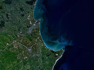
- Description: This is a NASA World Wind composite satellite image of New Zealand, showing Napier, Hastings, and Cape Kidnappers.
Informationen auf Deutsch
- Beschreibung: Dieses NASA World Wind-Bild zeigt den südlichen Teil der Hawke's Bay, insbesondere die Städte Napier und Hastings sowie Cape Kidnappers in Neuseeland.
लाइसेंस
| This image is in the public domain because it is a screenshot from NASA’s globe software World Wind using a public domain layer, such as Blue Marble, MODIS, Landsat, SRTM, USGS or GLOBE.
|
 |
चित्र का इतिहास
फ़ाइलका पुराना अवतरण देखने के लिये दिनांक/समय पर क्लिक करें।
| दिनांक/समय | थंबनेल | आकार | सदस्य | प्रतिक्रिया | |
|---|---|---|---|---|---|
| वर्तमान | 21:04, 18 मार्च 2006 | | 1,280 × 948 (149 KB) | 2000 | ===Informations in English=== *Description: NASA World Wind composite satellite image of New Zealand, showing Napier, Hastings, and Cape Kidnappers. ===Informationen auf Deutsch=== *Beschreibung: Dieses NASA World Wind-Bild zeigt d |
चित्र का उपयोग
निम्नलिखित पन्ने इस चित्र से जुडते हैं :
चित्र का वैश्विक उपयोग
इस चित्र का उपयोग इन दूसरे विकियों में किया जाता है:
- de.wikipedia.org पर उपयोग
- en.wikipedia.org पर उपयोग
- eo.wikipedia.org पर उपयोग
- fr.wikipedia.org पर उपयोग
- it.wikipedia.org पर उपयोग
- nn.wikipedia.org पर उपयोग
- www.wikidata.org पर उपयोग
- zh.wikipedia.org पर उपयोग