चित्र:New guinea named.PNG

इस पूर्वावलोकन का आकार: 800 × 417 पिक्सेल। दूसरे रेसोल्यूशन्स: 320 × 167 पिक्सेल | 640 × 333 पिक्सेल | 1,024 × 534 पिक्सेल | 1,280 × 667 पिक्सेल | 2,205 × 1,149 पिक्सेल।
मूल चित्र ((2,205 × 1,149 पिक्सेल, फ़ाइल का आकार: 86 KB, MIME प्रकार: image/png))
|
|
यह फ़ाइल विकिमेडिया कॉमन्स से है। वहाँ पर इसका विवरण पृष्ठ निम्नोक्त है। कॉमन्स मुक्त लाइसेंसों के अंतर्गत उपलब्ध मीडिया फ़ाइलों का संग्रह है। आप भी इसमें मदद कर सकते हैं। |

|
This locator map image could be re-created using vector graphics as an SVG file. This has several advantages; see Commons:Media for cleanup for more information. If an SVG form of this image is available, please upload it and afterwards replace this template with
{{vector version available|new image name}}.
It is recommended to name the SVG file “New guinea named.svg”—then the template Vector version available (or Vva) does not need the new image name parameter. |
सारांश
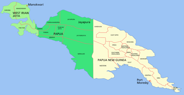
Map of the island of w:New Guinea
- Green = western New Guinea, (Indonesia) divided into the two provinces of West Irian Jaya (light green) and Papua (dark green).
- Beige = eastern New Guinea, the 'mainland' portion of the nation of Papua New Guinea
Shows capital cities and provinces
For a blank map see Image:New guinea blank.PNG
लाइसेंस

|
इस दस्तावेज़ को Free Software Foundation द्वारा प्रकाशित GNU मुक्त प्रलेख लाइसेंस के संस्करण 1.2 या नए (बिना किसी अपरिवर्तनीय अनुभागों और अगले या पिछले आवरण के टेक्स्ट के) के अंतर्गत प्रतिलिपि बनाने, बाँटने और/या बदलने की अनुमति प्रदान की जाती है। इस लाइसेंस की एक प्रतिलिपि GNU मुक्त प्रलेख लाइसेंस नामक अनुभाग में शामिल है। |
| इस फ़ाइल को क्रिएटिव कॉमन्स श्रेय-समानसांझा 3.0 अनरिपोर्टेड लाइसेंस के अंतर्गत लाइसेंस किया गया है। | ||
| ||
| This licensing tag was added to this file as part of the GFDL licensing update. |
चित्र का इतिहास
फ़ाइलका पुराना अवतरण देखने के लिये दिनांक/समय पर क्लिक करें।
| दिनांक/समय | थंबनेल | आकार | सदस्य | प्रतिक्रिया | |
|---|---|---|---|---|---|
| वर्तमान | 04:29, 24 फ़रवरी 2006 | | 2,205 × 1,149 (86 KB) | Roke~commonswiki | Map of the island of New Guinea Category: New Guinea |
चित्र का उपयोग
इस चित्र से कोई पन्ने नहीं जुड़ते
चित्र का वैश्विक उपयोग
इस चित्र का उपयोग इन दूसरे विकियों में किया जाता है:
- af.wikipedia.org पर उपयोग
- als.wikipedia.org पर उपयोग
- ar.wikipedia.org पर उपयोग
- ban.wikipedia.org पर उपयोग
- bat-smg.wikipedia.org पर उपयोग
- ca.wikipedia.org पर उपयोग
- cs.wikipedia.org पर उपयोग
- de.wikipedia.org पर उपयोग
- de.wikinews.org पर उपयोग
- el.wikipedia.org पर उपयोग
- en.wikipedia.org पर उपयोग
- en.wiktionary.org पर उपयोग
- es.wikipedia.org पर उपयोग
- fa.wikipedia.org पर उपयोग
- fi.wikipedia.org पर उपयोग
- fr.wikipedia.org पर उपयोग
- gd.wikipedia.org पर उपयोग
- gl.wikipedia.org पर उपयोग
- gn.wikipedia.org पर उपयोग
- hak.wikipedia.org पर उपयोग
- he.wikipedia.org पर उपयोग
- hu.wikipedia.org पर उपयोग
- id.wikipedia.org पर उपयोग
- id.wiktionary.org पर उपयोग
- ja.wikipedia.org पर उपयोग
- ka.wikipedia.org पर उपयोग
इस चित्र के वैश्विक उपयोग की अधिक जानकारी देखें।