चित्र:ORD Airport Diagram.svg

पूर्वावलोकन PNG का आकार SVG फ़ाइल: 390 × 599 पिक्सेल दूसरे रेसोल्यूशन्स: 156 × 240 पिक्सेल | 313 × 480 पिक्सेल | 500 × 768 पिक्सेल | 667 × 1,024 पिक्सेल | 1,334 × 2,048 पिक्सेल | 484 × 743 पिक्सेल।
मूल चित्र (SVG फ़ाइल, साधारणतः 484 × 743 पिक्सेल, फ़ाइल का आकार: 3.46 MB)
|
|
यह फ़ाइल विकिमेडिया कॉमन्स से है। वहाँ पर इसका विवरण पृष्ठ निम्नोक्त है। कॉमन्स मुक्त लाइसेंसों के अंतर्गत उपलब्ध मीडिया फ़ाइलों का संग्रह है। आप भी इसमें मदद कर सकते हैं। |
सारांश
| विवरण |
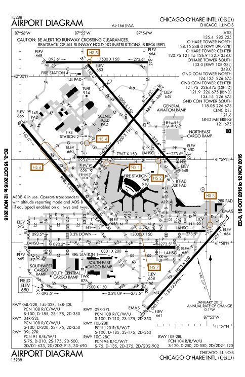
English: FAA Airport Diagram of O'Hare International Airport. |
| दिनांक | |
| स्रोत |
FAA Airport Diagrams; note that these change every 28 days. Taken from PDF on FAA site and converted to SVG using en:Wikipedia:How to draw SVG circuits using Xcircuit. |
| लेखक | Produced by the National Aeronautical Charting Office (NACO), a department of the United States en:Federal Aviation Administration. |
| कैमरा स्थान | | यह और अन्य आसपास की छवियों यहां पर देखें: ओपन स्ट्रीट मैप |
|---|
W3C-validity not checked.
लाइसेंस
This image or file is a work of a Federal Aviation Administration employee, taken or made as part of that person's official duties. As a work of the U.S. federal government, the image is in the public domain in the United States.
|
 |
चित्र का इतिहास
फ़ाइलका पुराना अवतरण देखने के लिये दिनांक/समय पर क्लिक करें।
| दिनांक/समय | थंबनेल | आकार | सदस्य | प्रतिक्रिया | |
|---|---|---|---|---|---|
| वर्तमान | 21:27, 15 अक्टूबर 2015 | | 484 × 743 (3.46 MB) | BorgHunter | New diagram with 10R/28L |
| 14:36, 8 नवम्बर 2014 |  | 484 × 743 (1.63 MB) | BorgHunter | Updated diagram includes runway 28C | |
| 14:02, 2 मई 2013 |  | 378 × 547 (1.62 MB) | Grendelkhan | SVG version of FAA's PDF diagram. |
चित्र का उपयोग
निम्नलिखित पन्ने इस चित्र से जुडते हैं :
चित्र का वैश्विक उपयोग
इस चित्र का उपयोग इन दूसरे विकियों में किया जाता है:
- ar.wikipedia.org पर उपयोग
- de.wikipedia.org पर उपयोग
- en.wikipedia.org पर उपयोग
- eo.wikipedia.org पर उपयोग
- fr.wikipedia.org पर उपयोग
- it.wikipedia.org पर उपयोग
- ja.wikipedia.org पर उपयोग
- ko.wikipedia.org पर उपयोग
- pl.wikipedia.org पर उपयोग
- ru.wikipedia.org पर उपयोग
- sk.wikipedia.org पर उपयोग
- sl.wikipedia.org पर उपयोग
- th.wikipedia.org पर उपयोग
- www.wikidata.org पर उपयोग