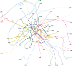
चित्र:Paris Metro map.gif

इस पूर्वावलोकन का आकार: 653 × 600 पिक्सेल। दूसरे रेसोल्यूशन्स: 261 × 240 पिक्सेल | 523 × 480 पिक्सेल | 836 × 768 पिक्सेल | 1,115 × 1,024 पिक्सेल | 1,927 × 1,770 पिक्सेल।
मूल चित्र ((1,927 × 1,770 पिक्सेल, फ़ाइल का आकार: 214 KB, MIME प्रकार: image/gif))
चित्र का इतिहास
फ़ाइलका पुराना अवतरण देखने के लिये दिनांक/समय पर क्लिक करें।
| दिनांक/समय | थंबनेल | आकार | सदस्य | प्रतिक्रिया | |
|---|---|---|---|---|---|
| वर्तमान | 04:12, 2 मई 2006 |  | 1,927 × 1,770 (214 KB) | Gonioul | |
| 14:12, 14 दिसम्बर 2005 |  | 1,899 × 1,769 (175 KB) | Poulpy | == Summary == '''Author''': en:Metropolitan '''Origin''': en:Image:Paris Metro map.gif '''Description''': Paris metro network pictured at a geographically accurate scale. Released by the author into the public domain. |
चित्र का उपयोग
इस चित्र से कोई पन्ने नहीं जुड़ते
चित्र का वैश्विक उपयोग
इस चित्र का उपयोग इन दूसरे विकियों में किया जाता है:
- ca.wikipedia.org पर उपयोग
- cv.wikipedia.org पर उपयोग
- en.wikipedia.org पर उपयोग
- eo.wikipedia.org पर उपयोग
- es.wikipedia.org पर उपयोग
- ja.wikipedia.org पर उपयोग
- lb.wikipedia.org पर उपयोग
- sk.wikipedia.org पर उपयोग


