चित्र:Periplous of the Erythraean Sea.svg

पूर्वावलोकन PNG का आकार SVG फ़ाइल: 800 × 564 पिक्सेल दूसरे रेसोल्यूशन्स: 320 × 226 पिक्सेल | 640 × 452 पिक्सेल | 1,024 × 722 पिक्सेल | 1,280 × 903 पिक्सेल | 2,560 × 1,806 पिक्सेल।
मूल चित्र (SVG फ़ाइल, साधारणतः 1,280 × 903 पिक्सेल, फ़ाइल का आकार: 1.39 MB)
|
|
यह फ़ाइल विकिमेडिया कॉमन्स से है। वहाँ पर इसका विवरण पृष्ठ निम्नोक्त है। कॉमन्स मुक्त लाइसेंसों के अंतर्गत उपलब्ध मीडिया फ़ाइलों का संग्रह है। आप भी इसमें मदद कर सकते हैं। |
सारांश
| विवरण |
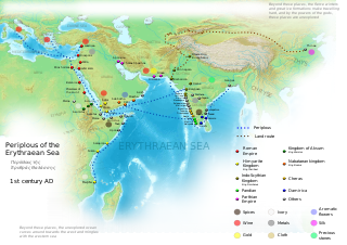
English: Periplous of the Erythreaen Sea map, according to the description from source text (https://el.wikisource.org/wiki/Περίπλους_τῆς_Ἐρυθράς_Θαλάσσης). Original names have been transcribed to Latin alphabet when possible. For the Greek names look at the respective Greek version of the map.
Ελληνικά: Χάρτης του περίπλου της Ερυθράς Θαλάσσης(Αγγλική έκδοση), σύμφωνα με την περιγραφή του κειμένου (https://el.wikisource.org/wiki/Περίπλους_τῆς_Ἐρυθράς_Θαλάσσης). हिन्दी: एरिथ्रेअन सागर के पेरिप्लस के नाम, मार्ग और स्थान
Català: Mapa del Periple de la Mar Eritrea, segons la descripció de la font (https://el.wikisource.org/wiki/Περίπλους_τῆς_Ἐρυθράς_Θαλάσσης). Els noms originals s'han transcrit a l'alfabet llatí quan ha estat possible. Per als noms grecs mireu la versió grega del mapa. |
| दिनांक | |
| स्रोत | अपना कार्य |
| लेखक | George Tsiagalakis |
| अनुमति (इस चित्र का पुनः उपयोग करना) |
Mention author and licence when using this work, e.g. "George Tsiagalakis / CC-BY-SA-4 licence" |
| दूसरे संस्करण |
|


इस W3C-अनिर्दिष्ट वेक्टर चित्र को Inkscape की मदद से बनाया गया था .

|
इस SVG फ़ाइल में एम्बेड किया हुआ टेक्स्ट है जिसे आप अपनी भाषा में किसी भी सक्षम SVG एडिटर, टेक्स्ट एडिटर, या फिर SVG Translate उपकरण की मदद से अनुवादित कर सकते हैं। अधिक जानकारी के लिए देखें: SVG फ़ाइलों को अनुवादित करने के बारे में। |
लाइसेंस
मैं, इस कार्य का/की कॉपीराइट धारक, इसे निम्न लाइसेंस के अंतर्गत प्रकाशित करता/करती हूँ:
| Multi-licensed with all versions of the Creative Commons Attribution Share-Alike License | ||
| I agree to multi-license my contributions, unless otherwise stated, under the GFDL and the Creative Commons Attribution Share-Alike license version 1.0, version 2.0, version 2.5, version 3.0, and all future versions of the Creative Commons Attribution Share-Alike license. Please be aware that other contributors might not do the same, so if you want to use my contributions under the Creative Commons terms, please check the CC dual-license and Multi-licensing guides. | ||

|
इस दस्तावेज़ को Free Software Foundation द्वारा प्रकाशित GNU मुक्त प्रलेख लाइसेंस के संस्करण 1.2 या नए (बिना किसी अपरिवर्तनीय अनुभागों और अगले या पिछले आवरण के टेक्स्ट के) के अंतर्गत प्रतिलिपि बनाने, बाँटने और/या बदलने की अनुमति प्रदान की जाती है। इस लाइसेंस की एक प्रतिलिपि GNU मुक्त प्रलेख लाइसेंस नामक अनुभाग में शामिल है। |
This file is licensed under the Creative Commons Attribution-Share Alike 4.0 International, 3.0 Unported, 2.5 Generic, 2.0 Generic and 1.0 Generic license.
- आप खुलकर:
- बाँट सकते हैं – रचना की प्रतिलिपि बना सकते हैं, बाँँट सकते हैं और संचारित कर सकते हैं
- रीमिक्स कर सकते हैं – कार्य को अनुकूलित कर सकते हैं
- निम्नलिखित शर्तों के अंतर्गत:
- श्रेय – यह अनिवार्य है कि आप यथोचित श्रेय प्रदान करें, लाइसेंस की कड़ी प्रदान करें, और अगर कोई बदलाव हुए हों तो उन्हें इंगित करें। आप ऐसा किसी भी उचित तरीके से कर सकते हैं, लेकिन किसी भी तरह उससे यह नहीं संकेत नहीं किया जाना चाहिए कि लाइसेंसधारी द्वारा आपको अथवा आपके इस प्रयोग का समर्थन किया जा रहा हो।
- समानसांझा – अगर आप इस रचना में कोई बदलाव करते हैं या इसपर आधारित कुछ रचित करते हैं तो आप अपने योगदान को सिर्फ इसी या इसके सामान किसी लाइसेंस के अंतर्गत बाँट सकते हैं।
चित्र का इतिहास
फ़ाइलका पुराना अवतरण देखने के लिये दिनांक/समय पर क्लिक करें।
| दिनांक/समय | थंबनेल | आकार | सदस्य | प्रतिक्रिया | |
|---|---|---|---|---|---|
| वर्तमान | 17:48, 29 सितंबर 2023 | | 1,280 × 903 (1.39 MB) | Joutbis | File uploaded using svgtranslate tool (https://svgtranslate.toolforge.org/). Added translation for ca. |
| 17:33, 29 सितंबर 2023 |  | 1,280 × 903 (1.38 MB) | Joutbis | File uploaded using svgtranslate tool (https://svgtranslate.toolforge.org/). Added translation for ca. | |
| 21:13, 1 फ़रवरी 2023 |  | 1,280 × 903 (1.32 MB) | Theklan | File uploaded using svgtranslate tool (https://svgtranslate.toolforge.org/). Added translation for eu. | |
| 19:12, 9 जनवरी 2022 |  | 1,280 × 903 (1.28 MB) | Mr. Ibrahem | Reverted to version as of 11:44, 6 May 2021 (UTC) | |
| 13:29, 9 जनवरी 2022 |  | 1,280 × 903 (1.28 MB) | Mr. Ibrahem | File uploaded using svgtranslate tool (https://svgtranslate.toolforge.org/). Added translation for ar. | |
| 11:44, 6 मई 2021 |  | 1,280 × 903 (1.28 MB) | Andrei Stroe | File uploaded using svgtranslate tool (https://svgtranslate.toolforge.org/). Added translation for ro. | |
| 16:10, 31 जनवरी 2015 |  | 1,280 × 903 (1.28 MB) | Gts-tg | Small updates in spelling of city names | |
| 15:39, 31 जनवरी 2015 |  | 1,280 × 903 (1.28 MB) | Gts-tg | More accurate positioning for Nikon(os) and Sarapion(os), corresponding to modern Barawe and Mogadishu respectively. Improved legibility of place names | |
| 03:15, 29 जनवरी 2015 |  | 1,280 × 903 (1.28 MB) | Gts-tg | Updates as [https://en.wikipedia.org/wiki/User_talk:Gts-tg#Periplus_svg indicated by Wikipedia editors] | |
| 17:31, 26 दिसम्बर 2014 |  | 1,280 × 903 (1.28 MB) | Gts-tg | User created page with UploadWizard |
चित्र का उपयोग
निम्नलिखित पन्ने इस चित्र से जुडते हैं :
चित्र का वैश्विक उपयोग
इस चित्र का उपयोग इन दूसरे विकियों में किया जाता है:
- af.wikipedia.org पर उपयोग
- ar.wikipedia.org पर उपयोग
- arz.wikipedia.org पर उपयोग
- az.wikipedia.org पर उपयोग
- bg.wikipedia.org पर उपयोग
- bn.wikipedia.org पर उपयोग
- ca.wikipedia.org पर उपयोग
- ceb.wikipedia.org पर उपयोग
- cs.wikipedia.org पर उपयोग
- da.wikipedia.org पर उपयोग
- de.wikipedia.org पर उपयोग
- el.wikipedia.org पर उपयोग
- en.wikipedia.org पर उपयोग
- Arabian Sea
- History of Cambodia
- Foreign relations of Ethiopia
- Red Sea
- Kozhikode
- Kochi
- Malappuram district
- Tamils
- Roman Egypt
- Spice trade
- Trade route
- Bharuch
- History of South India
- Kollam
- Barbarikon
- Hippalus
- Islam in India
- Opone
- Mappila Muslims
- Sino-Roman relations
- Christianity in India
- Timeline of international trade
इस चित्र के वैश्विक उपयोग की अधिक जानकारी देखें।