चित्र:Polynesian triangle.svg

पूर्वावलोकन PNG का आकार SVG फ़ाइल: 600 × 600 पिक्सेल दूसरे रेसोल्यूशन्स: 240 × 240 पिक्सेल | 480 × 480 पिक्सेल | 768 × 768 पिक्सेल | 1,024 × 1,024 पिक्सेल | 2,048 × 2,048 पिक्सेल।
मूल चित्र (SVG फ़ाइल, साधारणतः 600 × 600 पिक्सेल, फ़ाइल का आकार: 281 KB)
|
|
यह फ़ाइल विकिमेडिया कॉमन्स से है। वहाँ पर इसका विवरण पृष्ठ निम्नोक्त है। कॉमन्स मुक्त लाइसेंसों के अंतर्गत उपलब्ध मीडिया फ़ाइलों का संग्रह है। आप भी इसमें मदद कर सकते हैं। |
सारांश
| विवरण |
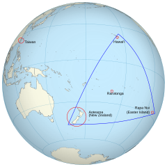
English: An orthographic projection of the pacific ocean, showing land outlines (resolution ~0.5 degrees) and the Polynesian triangle between Hawai'i, Rapa Nui and Aotearoa. Created using perlshaper to convert Natural Earth Data into an SVG file. Some tweaking was then done in Inkscape to fix up boundaries for countries on the edge of the projection. |
| दिनांक | |
| स्रोत | अपना कार्य |
| लेखक | Gringer |
| दूसरे संस्करण | Macedonian version |
| SVG genesis | इस वेक्टर चित्र को Inkscape की मदद से बनाया गया था। |
लाइसेंस
मैं, इस कार्य का/की कॉपीराइट धारक, इसे निम्न लाइसेंस के अंतर्गत प्रकाशित करता/करती हूँ:
इस फ़ाइल को क्रिएटिव कॉमन्स श्रेय 3.0 अनरिपोर्टेड लाइसेंस के अंतर्गत लाइसेंस किया गया है।
- आप खुलकर:
- बाँट सकते हैं – रचना की प्रतिलिपि बना सकते हैं, बाँँट सकते हैं और संचारित कर सकते हैं
- रीमिक्स कर सकते हैं – कार्य को अनुकूलित कर सकते हैं
- निम्नलिखित शर्तों के अंतर्गत:
- श्रेय – यह अनिवार्य है कि आप यथोचित श्रेय प्रदान करें, लाइसेंस की कड़ी प्रदान करें, और अगर कोई बदलाव हुए हों तो उन्हें इंगित करें। आप ऐसा किसी भी उचित तरीके से कर सकते हैं, लेकिन किसी भी तरह उससे यह नहीं संकेत नहीं किया जाना चाहिए कि लाइसेंसधारी द्वारा आपको अथवा आपके इस प्रयोग का समर्थन किया जा रहा हो।
चित्र का इतिहास
फ़ाइलका पुराना अवतरण देखने के लिये दिनांक/समय पर क्लिक करें।
| दिनांक/समय | थंबनेल | आकार | सदस्य | प्रतिक्रिया | |
|---|---|---|---|---|---|
| वर्तमान | 02:36, 16 जून 2013 | | 600 × 600 (281 KB) | AnonMoos | adjust margins |
| 11:34, 3 सितंबर 2010 |  | 550 × 550 (290 KB) | Gringer | updated with [http://www.naturalearthdata.com Natural Earth Data] | |
| 03:01, 24 नवम्बर 2009 |  | 542 × 542 (90 KB) | Gringer | {{Information |Description={{en|1=An orthographic projection of the pacific ocean, showing land outlines (resolution ~0.5 degrees) and the Polynesian triangle between Hawai'i, Rapa Nui and Aotearoa. Created using a custom perl script (http://user.interfac |
चित्र का उपयोग
निम्नलिखित पन्ने इस चित्र से जुडते हैं :
चित्र का वैश्विक उपयोग
इस चित्र का उपयोग इन दूसरे विकियों में किया जाता है:
- af.wikipedia.org पर उपयोग
- ca.wikipedia.org पर उपयोग
- en.wikipedia.org पर उपयोग
- es.wikipedia.org पर उपयोग
- fi.wiktionary.org पर उपयोग
- fr.wikipedia.org पर उपयोग
- ia.wikipedia.org पर उपयोग
- la.wikipedia.org पर उपयोग
- pl.wikipedia.org पर उपयोग
- pt.wiktionary.org पर उपयोग
- ru.wikipedia.org पर उपयोग
- sr.wikipedia.org पर उपयोग
- uk.wikipedia.org पर उपयोग
- www.wikidata.org पर उपयोग