चित्र:Republic of Venice 1789.svg

पूर्वावलोकन PNG का आकार SVG फ़ाइल: 450 × 456 पिक्सेल दूसरे रेसोल्यूशन्स: 237 × 240 पिक्सेल | 474 × 480 पिक्सेल | 758 × 768 पिक्सेल | 1,011 × 1,024 पिक्सेल | 2,021 × 2,048 पिक्सेल।
मूल चित्र (SVG फ़ाइल, साधारणतः 450 × 456 पिक्सेल, फ़ाइल का आकार: 927 KB)
|
|
यह फ़ाइल विकिमेडिया कॉमन्स से है। वहाँ पर इसका विवरण पृष्ठ निम्नोक्त है। कॉमन्स मुक्त लाइसेंसों के अंतर्गत उपलब्ध मीडिया फ़ाइलों का संग्रह है। आप भी इसमें मदद कर सकते हैं। |
सारांश


.svg)
.svg)
.svg)
.svg)
.svg)


.svg)
.svg)
.svg)


.png)
.png)


.svg)


.svg)

.svg)


.svg)
.svg)
.svg)
.svg)


.svg)
.png)


.svg)


.svg)
.svg)


.svg)


.svg)


.svg)
.svg)
.svg)
.svg)
.svg)
.svg)
.svg)
_cropped.svg)
.svg)
.svg)
.svg)
.svg)
.svg)
.svg)
.svg)
.svg)
.svg)
.svg)
.svg)
.svg)
.svg)
.svg)
.svg)
.svg)
.svg)
.svg)
.svg)
.svg)
.svg)
.svg)
.svg)
.svg)
.svg)
.svg)
.svg)
.svg)
.svg)
.svg)
.svg)
.svg)
.svg)
.svg)
.svg)
.svg)
.svg)
.svg)
.svg)
.svg)
.svg)
.svg)
.svg)
.svg)
.svg)
लाइसेंस
मैं, इस कार्य का/की कॉपीराइट धारक, इसे निम्न लाइसेंस के अंतर्गत प्रकाशित करता/करती हूँ:
इस फ़ाइल को क्रिएटिव कॉमन्स श्रेय-समानसांझा 3.0 अनरिपोर्टेड लाइसेंस के अंतर्गत लाइसेंस किया गया है।
- आप खुलकर:
- बाँट सकते हैं – रचना की प्रतिलिपि बना सकते हैं, बाँँट सकते हैं और संचारित कर सकते हैं
- रीमिक्स कर सकते हैं – कार्य को अनुकूलित कर सकते हैं
- निम्नलिखित शर्तों के अंतर्गत:
- श्रेय – यह अनिवार्य है कि आप यथोचित श्रेय प्रदान करें, लाइसेंस की कड़ी प्रदान करें, और अगर कोई बदलाव हुए हों तो उन्हें इंगित करें। आप ऐसा किसी भी उचित तरीके से कर सकते हैं, लेकिन किसी भी तरह उससे यह नहीं संकेत नहीं किया जाना चाहिए कि लाइसेंसधारी द्वारा आपको अथवा आपके इस प्रयोग का समर्थन किया जा रहा हो।
- समानसांझा – अगर आप इस रचना में कोई बदलाव करते हैं या इसपर आधारित कुछ रचित करते हैं तो आप अपने योगदान को सिर्फ इसी या इसके सामान किसी लाइसेंस के अंतर्गत बाँट सकते हैं।
मूल अपलोड लॉग
This image is a derivative work of the following images:
- File:Europe_1789.svg licensed with Cc-by-sa-3.0
- 2013-04-14T03:44:26Z Alphathon 450x456 (858577 Bytes) Corrected some errors in northern Italy
- 2013-04-14T01:38:01Z Alphathon 450x456 (853881 Bytes) tweaked again
- 2013-04-14T01:36:10Z Alphathon 450x456 (853881 Bytes) Tweaked Holy Roman Empire border style
- 2013-04-14T01:33:26Z Alphathon 450x456 (853857 Bytes) == {{int:filedesc}} == {{Information |Description={{en|A blank Map of Europe circa 1789. This map also includes a border for the [[:en:Holy Roman Empire|Holy Roman Empire]]. Since there are so many small German states, they h
Uploaded with derivativeFX
चित्र का इतिहास
फ़ाइलका पुराना अवतरण देखने के लिये दिनांक/समय पर क्लिक करें।
| दिनांक/समय | थंबनेल | आकार | सदस्य | प्रतिक्रिया | |
|---|---|---|---|---|---|
| वर्तमान | 22:20, 26 नवम्बर 2021 | | 450 × 456 (927 KB) | Cplakidas | Fixing Venetian Albania, adding Cythera to Venice |
| 07:55, 17 अक्टूबर 2021 |  | 450 × 456 (803 KB) | Fenn-O-maniC | Fixed the Russo-Swedish border to match the Treaty of Åbo of 1743 | |
| 09:23, 27 फ़रवरी 2020 |  | 450 × 456 (821 KB) | Facquis | Clear map | |
| 17:16, 18 अप्रैल 2013 |  | 450 × 456 (820 KB) | Alphathon | Various fixes | |
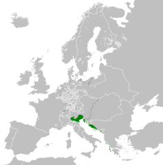
| 03:54, 14 अप्रैल 2013 |  | 450 × 456 (802 KB) | Alphathon | == {{int:filedesc}} == {{Information |Description={{en|A map of the Republic of Venice circa 1789.}}{{de|Eine Landkarte die Republik Venedig c. 1989.}} |Source={{Derived from|Europe_1789.svg|display=5... |
चित्र का उपयोग
निम्नलिखित पन्ने इस चित्र से जुडते हैं :
चित्र का वैश्विक उपयोग
इस चित्र का उपयोग इन दूसरे विकियों में किया जाता है:
- azb.wikipedia.org पर उपयोग
- bg.wikipedia.org पर उपयोग
- ca.wikipedia.org पर उपयोग
- ckb.wikipedia.org पर उपयोग
- cs.wikipedia.org पर उपयोग
- de.wikipedia.org पर उपयोग
- el.wikipedia.org पर उपयोग
- en.wikipedia.org पर उपयोग
- eu.wikipedia.org पर उपयोग
- fa.wikipedia.org पर उपयोग
- fy.wikipedia.org पर उपयोग
- he.wikipedia.org पर उपयोग
- hr.wikipedia.org पर उपयोग
- it.wikipedia.org पर उपयोग
- ko.wikipedia.org पर उपयोग
- lfn.wikipedia.org पर उपयोग
- lij.wikipedia.org पर उपयोग
- lmo.wikipedia.org पर उपयोग
- mk.wikipedia.org पर उपयोग
- ml.wikipedia.org पर उपयोग
- ms.wikipedia.org पर उपयोग
- pl.wikipedia.org पर उपयोग
- pt.wikipedia.org पर उपयोग
- rue.wikipedia.org पर उपयोग
- ru.wikipedia.org पर उपयोग
- sk.wikipedia.org पर उपयोग
- szl.wikipedia.org पर उपयोग
- tr.wikipedia.org पर उपयोग
- uk.wikipedia.org पर उपयोग
- zh.wikipedia.org पर उपयोग