चित्र:Road network CPEC.jpg
इस पूर्वावलोकन का आकार: 799 × 600 पिक्सेल। दूसरे रेसोल्यूशन्स: 320 × 240 पिक्सेल | 640 × 480 पिक्सेल | 962 × 722 पिक्सेल।
मूल चित्र ((962 × 722 पिक्सेल, फ़ाइल का आकार: 137 KB, MIME प्रकार: image/jpeg))
|
|
यह फ़ाइल विकिमेडिया कॉमन्स से है। वहाँ पर इसका विवरण पृष्ठ निम्नोक्त है। कॉमन्स मुक्त लाइसेंसों के अंतर्गत उपलब्ध मीडिया फ़ाइलों का संग्रह है। आप भी इसमें मदद कर सकते हैं। |
सारांश
| विवरण |
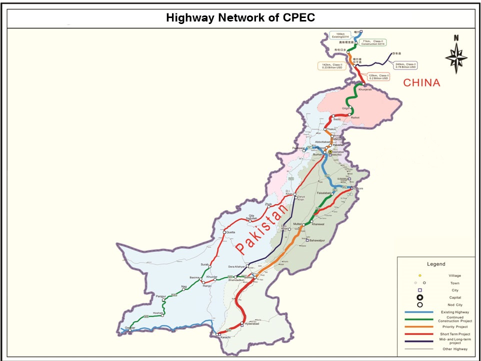
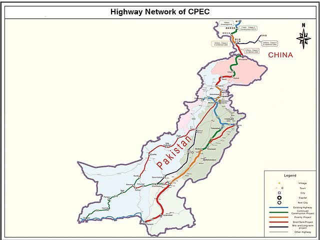
English: It describes Eastern Western and Central alignment of CPEC |
| दिनांक | |
| स्रोत | http://www.pc.gov.pk/wp-content/uploads/2016/01/Highway-Network-of-cpac-new.jpg |
| लेखक | Government of Pakistan |
This file is in the public domain because Planning commision of Pakistan
|
चित्र का इतिहास
फ़ाइलका पुराना अवतरण देखने के लिये दिनांक/समय पर क्लिक करें।
| दिनांक/समय | थंबनेल | आकार | सदस्य | प्रतिक्रिया | |
|---|---|---|---|---|---|
| वर्तमान | 00:19, 28 सितंबर 2023 | | 962 × 722 (137 KB) | Eggrollll | Reverted to version as of 17:10, 4 December 2020 (UTC) |
| 17:11, 4 दिसम्बर 2020 |  | 962 × 722 (125 KB) | Pathfinder454 | Map published by user Badri2017 is forged / edited without copyrights obtained from Government of Pakistan. Original file published by user Baltistani478 is the actual map depicting road networks of CPEC as published at official website http://cpec.gov.pk/map-single/1 Therefore File Reverted to version as of 16:49, 23 May 2016 (UTC) | |
| 17:10, 4 दिसम्बर 2020 |  | 962 × 722 (137 KB) | Pathfinder454 | Reverted to version as of 10:15, 19 July 2017 (UTC) Map published by user Badri2017 is forged / edited without copyrights obtained from Government of Pakistan. Original file published by user Baltistani478 is the actual map depicting road networks of CPEC as published at official website http://cpec.gov.pk/map-single/1 Therefore File Reverted to version as of 16:49, 23 May 2016 (UTC | |
| 17:01, 4 दिसम्बर 2020 |  | 962 × 722 (125 KB) | Pathfinder454 | Map published by user Badri2017 is forged / edited without copyrights obtained from Government of Pakistan. Original file published by user Baltistani478 is the actual map depicting road networks of CPEC as published at official website http://cpec.gov.pk/map-single/1 Therefore File Reverted to version as of 16:49, 23 May 2016 (UTC) | |
| 10:15, 19 जुलाई 2017 |  | 962 × 722 (137 KB) | Badri2017 | Neutral Map, Indian administered Kashmir is neither part of CPEC nor Pak territory | |
| 16:49, 23 मई 2016 |  | 962 × 722 (125 KB) | Baltistani478 | {{subst:Upload marker added by en.wp UW}} {{Information |Description = {{en|It describes Eastern Western and Central alignment of CPEC}} |Source = http://www.pc.gov.pk/wp-content/uploads/2016/01/Highway-Network-of-cpac-new.jpg |Date = January 2016 |Aut... |
चित्र का उपयोग
निम्नलिखित पन्ने इस चित्र से जुडते हैं :
चित्र का वैश्विक उपयोग
इस चित्र का उपयोग इन दूसरे विकियों में किया जाता है:
- ar.wikipedia.org पर उपयोग
- bn.wikipedia.org पर उपयोग
- ca.wikipedia.org पर उपयोग
- en.wikipedia.org पर उपयोग
- eo.wikinews.org पर उपयोग
- mr.wikipedia.org पर उपयोग
- pa.wikipedia.org पर उपयोग
- pnb.wikipedia.org पर उपयोग
- sat.wikipedia.org पर उपयोग
- sd.wikipedia.org पर उपयोग
- ta.wikipedia.org पर उपयोग
- zh.wikipedia.org पर उपयोग