चित्र:Sarcophilus harrisii extent.png
इससे बड़ा रेसोल्यूशन उपलब्ध नहीं हैं।
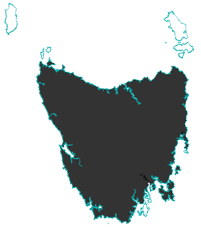
Sarcophilus_harrisii_extent.png ((403 × 461 पिक्सेल, फ़ाइल का आकार: 15 KB, MIME प्रकार: image/png))
|
|
यह फ़ाइल विकिमेडिया कॉमन्स से है। वहाँ पर इसका विवरण पृष्ठ निम्नोक्त है। कॉमन्स मुक्त लाइसेंसों के अंतर्गत उपलब्ध मीडिया फ़ाइलों का संग्रह है। आप भी इसमें मदद कर सकते हैं। |
सारांश
| विवरण |
English: Map showing the extent of the Tasmanian Devil, made from data generated in 2008 by the IUCN, and using an Australian coastline vector from CloudMade Downloads. Shows the Tasmanian Devil's extent on the main island of Tasmania and Robbins Island.
http://www.iucnredlist.org/technical-documents/spatial-data http://downloads.cloudmade.com/ |
| दिनांक | Based on data from 2008. |
| स्रोत | IUCN and CloudMade Downloads |
| लेखक | I did, using data from the IUCN redlist and a coastline of Australia from CloudMade Downloads. |

इस फ़ाइल को क्रिएटिव कॉमन्स श्रेय-समानसांझा 3.0 अनरिपोर्टेड लाइसेंस के अंतर्गत लाइसेंस किया गया है।
श्रेय: IUCN Red List of Threatened Species, species assessors and the authors of the spatial data.
- आप खुलकर:
- बाँट सकते हैं – रचना की प्रतिलिपि बना सकते हैं, बाँँट सकते हैं और संचारित कर सकते हैं
- रीमिक्स कर सकते हैं – कार्य को अनुकूलित कर सकते हैं
- निम्नलिखित शर्तों के अंतर्गत:
- श्रेय – यह अनिवार्य है कि आप यथोचित श्रेय प्रदान करें, लाइसेंस की कड़ी प्रदान करें, और अगर कोई बदलाव हुए हों तो उन्हें इंगित करें। आप ऐसा किसी भी उचित तरीके से कर सकते हैं, लेकिन किसी भी तरह उससे यह नहीं संकेत नहीं किया जाना चाहिए कि लाइसेंसधारी द्वारा आपको अथवा आपके इस प्रयोग का समर्थन किया जा रहा हो।
- समानसांझा – अगर आप इस रचना में कोई बदलाव करते हैं या इसपर आधारित कुछ रचित करते हैं तो आप अपने योगदान को सिर्फ इसी या इसके सामान किसी लाइसेंस के अंतर्गत बाँट सकते हैं।
You Bastard!!
लाइसेंस
इस फ़ाइल को क्रिएटिव कॉमन्स श्रेय-समानसांझा 3.0 अनरिपोर्टेड लाइसेंस के अंतर्गत लाइसेंस किया गया है।
- आप खुलकर:
- बाँट सकते हैं – रचना की प्रतिलिपि बना सकते हैं, बाँँट सकते हैं और संचारित कर सकते हैं
- रीमिक्स कर सकते हैं – कार्य को अनुकूलित कर सकते हैं
- निम्नलिखित शर्तों के अंतर्गत:
- श्रेय – यह अनिवार्य है कि आप यथोचित श्रेय प्रदान करें, लाइसेंस की कड़ी प्रदान करें, और अगर कोई बदलाव हुए हों तो उन्हें इंगित करें। आप ऐसा किसी भी उचित तरीके से कर सकते हैं, लेकिन किसी भी तरह उससे यह नहीं संकेत नहीं किया जाना चाहिए कि लाइसेंसधारी द्वारा आपको अथवा आपके इस प्रयोग का समर्थन किया जा रहा हो।
- समानसांझा – अगर आप इस रचना में कोई बदलाव करते हैं या इसपर आधारित कुछ रचित करते हैं तो आप अपने योगदान को सिर्फ इसी या इसके सामान किसी लाइसेंस के अंतर्गत बाँट सकते हैं।
Shake that Bit
चित्र का इतिहास
फ़ाइलका पुराना अवतरण देखने के लिये दिनांक/समय पर क्लिक करें।
| दिनांक/समय | थंबनेल | आकार | सदस्य | प्रतिक्रिया | |
|---|---|---|---|---|---|
| वर्तमान | 23:08, 23 मार्च 2014 | | 403 × 461 (15 KB) | Forward Unto Dawn | Updating image to include the Maria Island population. |
| 10:44, 5 फ़रवरी 2011 |  | 403 × 461 (32 KB) | Maproom | Corrected aspect ratio. Trimmed blank margins. | |
| 05:23, 12 सितंबर 2010 |  | 749 × 561 (20 KB) | Malkinann | {{Information |Description={{en|1= Map showing the extent of the Tasmanian Devil, made from data generated in 2008 by the IUCN, and using an Australian coastline vector from CloudMade Downloads. Shows the Tasmanian Devil's extent on the main island of Ta |
चित्र का उपयोग
निम्नलिखित पन्ने इस चित्र से जुडते हैं :
चित्र का वैश्विक उपयोग
इस चित्र का उपयोग इन दूसरे विकियों में किया जाता है:
- ar.wikipedia.org पर उपयोग
- arz.wikipedia.org पर उपयोग
- ast.wikipedia.org पर उपयोग
- avk.wikipedia.org पर उपयोग
- azb.wikipedia.org पर उपयोग
- bg.wikipedia.org पर उपयोग
- ca.wikipedia.org पर उपयोग
- ceb.wikipedia.org पर उपयोग
- ckb.wikipedia.org पर उपयोग
- cs.wikipedia.org पर उपयोग
- el.wikipedia.org पर उपयोग
- en.wikipedia.org पर उपयोग
- eo.wikipedia.org पर उपयोग
- es.wikipedia.org पर उपयोग
- et.wikipedia.org पर उपयोग
- eu.wikipedia.org पर उपयोग
- fa.wikipedia.org पर उपयोग
- ga.wikipedia.org पर उपयोग
- gl.wikipedia.org पर उपयोग
- hr.wikipedia.org पर उपयोग
- hu.wikipedia.org पर उपयोग
- hy.wikipedia.org पर उपयोग
- ia.wikipedia.org पर उपयोग
- incubator.wikimedia.org पर उपयोग
- it.wikipedia.org पर उपयोग
- jv.wikipedia.org पर उपयोग
- kk.wikipedia.org पर उपयोग
- ml.wikipedia.org पर उपयोग
- nl.wikipedia.org पर उपयोग
- nn.wikipedia.org पर उपयोग
- pl.wikipedia.org पर उपयोग
- pnb.wikipedia.org पर उपयोग
- pt.wikipedia.org पर उपयोग
- ru.wikipedia.org पर उपयोग
- sco.wikipedia.org पर उपयोग
- sk.wikipedia.org पर उपयोग
- sl.wikipedia.org पर उपयोग
- sr.wikipedia.org पर उपयोग
- sw.wikipedia.org पर उपयोग
- ta.wikipedia.org पर उपयोग
- th.wikipedia.org पर उपयोग
- tl.wikipedia.org पर उपयोग
- uk.wikipedia.org पर उपयोग
- ur.wikipedia.org पर उपयोग
इस चित्र के वैश्विक उपयोग की अधिक जानकारी देखें।