चित्र:Satellite image of Lebanon in March 2002.jpg

इस पूर्वावलोकन का आकार: 470 × 599 पिक्सेल। दूसरे रेसोल्यूशन्स: 188 × 240 पिक्सेल | 584 × 744 पिक्सेल।
मूल चित्र ((584 × 744 पिक्सेल, फ़ाइल का आकार: 59 KB, MIME प्रकार: image/jpeg))
|
|
यह फ़ाइल विकिमेडिया कॉमन्स से है। वहाँ पर इसका विवरण पृष्ठ निम्नोक्त है। कॉमन्स मुक्त लाइसेंसों के अंतर्गत उपलब्ध मीडिया फ़ाइलों का संग्रह है। आप भी इसमें मदद कर सकते हैं। |
सारांश
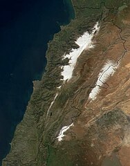
| विवरण | Satellite image of Lebanon in March 2002. |
| दिनांक | |
| स्रोत | Cropped from: http://visibleearth.nasa.gov/view_rec.php?id=2499 |
| लेखक | Jacques Descloitres, MODIS Land Rapid Response Team, NASA/GSFC |
| दूसरे संस्करण | Derivative works of this file: Jebel el gharbi in labanon satellite map.jpg |
लाइसेंस
| This file is in the public domain in the United States because it was solely created by NASA. NASA copyright policy states that "NASA material is not protected by copyright unless noted". (See Template:PD-USGov, NASA copyright policy page or JPL Image Use Policy.) | ||
 |
Warnings:
|
चित्र का इतिहास
फ़ाइलका पुराना अवतरण देखने के लिये दिनांक/समय पर क्लिक करें।
| दिनांक/समय | थंबनेल | आकार | सदस्य | प्रतिक्रिया | |
|---|---|---|---|---|---|
| वर्तमान | 14:06, 6 जनवरी 2005 | | 584 × 744 (59 KB) | Hautala | {{PD-USGov-NASA}} Satellite image of Lebanon in March 2002. Cropped image, original taken from NASA's Visible Earth http://visibleearth.nasa.gov/cgi-bin/viewrecord?12056 |
चित्र का उपयोग
निम्नलिखित पन्ने इस चित्र से जुडते हैं :
चित्र का वैश्विक उपयोग
इस चित्र का उपयोग इन दूसरे विकियों में किया जाता है:
- ab.wikipedia.org पर उपयोग
- af.wikipedia.org पर उपयोग
- ar.wikipedia.org पर उपयोग
- ar.wikiquote.org पर उपयोग
- arz.wikipedia.org पर उपयोग
- azb.wikipedia.org पर उपयोग
- az.wikipedia.org पर उपयोग
- ba.wikipedia.org पर उपयोग
- be.wikipedia.org पर उपयोग
- bg.wikipedia.org पर उपयोग
- bn.wikipedia.org पर उपयोग
- ca.wikipedia.org पर उपयोग
- ceb.wikipedia.org पर उपयोग
- ckb.wikipedia.org पर उपयोग
- cy.wikipedia.org पर उपयोग
- da.wikipedia.org पर उपयोग
- de.wikipedia.org पर उपयोग
- de.wiktionary.org पर उपयोग
- el.wikipedia.org पर उपयोग
- en.wikipedia.org पर उपयोग
इस चित्र के वैश्विक उपयोग की अधिक जानकारी देखें।