चित्र:Spice Islands (Tanzania).svg

पूर्वावलोकन PNG का आकार SVG फ़ाइल: 486 × 599 पिक्सेल दूसरे रेसोल्यूशन्स: 195 × 240 पिक्सेल | 389 × 480 पिक्सेल | 623 × 768 पिक्सेल | 831 × 1,024 पिक्सेल | 1,661 × 2,048 पिक्सेल | 713 × 879 पिक्सेल।
मूल चित्र (SVG फ़ाइल, साधारणतः 713 × 879 पिक्सेल, फ़ाइल का आकार: 15 KB)
|
|
यह फ़ाइल विकिमेडिया कॉमन्स से है। वहाँ पर इसका विवरण पृष्ठ निम्नोक्त है। कॉमन्स मुक्त लाइसेंसों के अंतर्गत उपलब्ध मीडिया फ़ाइलों का संग्रह है। आप भी इसमें मदद कर सकते हैं। |
.svg)
सारांश
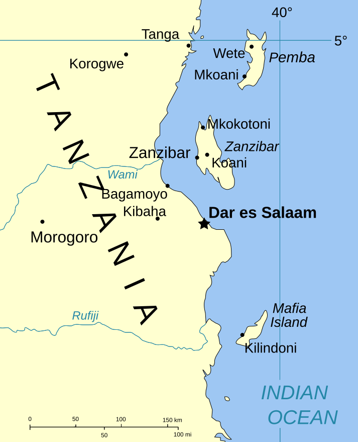
| विवरण | Part of the map of Tanzania, showing the Spice Islands. |
| दिनांक | |
| स्रोत | Vectors self-made in Inkscape. Source was cropped from http://www.lib.utexas.edu/maps/africa/tanzania_pol_2003.jpg which is said to be in the public domain in the Perry-Castañeda Map Collection FAQ. |
| लेखक | Mysid |
| अनुमति (इस चित्र का पुनः उपयोग करना) |
PD |
| दूसरे संस्करण |
Image:Spice Islands (Zanzibar highlighted).svg in French : Image:Spice_Islands_Tanzania-fr.svg in French : Image:Spice_Islands-Zanzibar_highlighted-fr.svg |
.svg)
लाइसेंस
| मैं, इस कार्य का/की कॉपीराइट धारक, इस कार्य को सार्वजनिक डोमेन में प्रकाशित करता/करती हूँ। यह पूरे विश्व में लागू होता है। कुछ देशों में यह कानूनी तौर पर नहीं हो सकता है; ऐसा हो तो: मैं सभी को इस कार्य का इस्तेमाल किसी भी उद्देश्य से, बिना किसी बाधाओं के इन शर्तों के कानून द्वारा अनिवार्य किए तक करने की अनुमति देता/देती हूँ। |
चित्र का इतिहास
फ़ाइलका पुराना अवतरण देखने के लिये दिनांक/समय पर क्लिक करें।
| दिनांक/समय | थंबनेल | आकार | सदस्य | प्रतिक्रिया | |
|---|---|---|---|---|---|
| वर्तमान | 20:01, 6 जनवरी 2007 | | 713 × 879 (15 KB) | Mysid | (a bit more) standard colors |
| 06:44, 29 मई 2006 |  | 713 × 879 (20 KB) | Mysid | corrected buggy scale | |
| 06:40, 29 मई 2006 |  | 713 × 879 (20 KB) | Mysid | New version, exported from CorelDraw (inkscape seems buggy) | |
| 18:23, 28 मई 2006 |  | 713 × 893 (37 KB) | Mysid | {{Information |Description=Part of the map of Tanzania, showing the Spice Islands. |Source=Vectors self-made in Inkscape. Source was cropped from http://www.lib.utexas.edu/maps/africa/tanzania_pol_2003.jpg which is said to be in the pu |
चित्र का उपयोग
इस चित्र से कोई पन्ने नहीं जुड़ते
चित्र का वैश्विक उपयोग
इस चित्र का उपयोग इन दूसरे विकियों में किया जाता है:
- ckb.wikipedia.org पर उपयोग
- da.wikipedia.org पर उपयोग
- eo.wikipedia.org पर उपयोग
- eu.wikipedia.org पर उपयोग
- fa.wikipedia.org पर उपयोग
- fo.wikipedia.org पर उपयोग
- fr.wikipedia.org पर उपयोग
- hr.wikipedia.org पर उपयोग
- it.wikipedia.org पर उपयोग
- ja.wikipedia.org पर उपयोग
- mi.wikipedia.org पर उपयोग
- nl.wikipedia.org पर उपयोग
- no.wikipedia.org पर उपयोग
- pt.wikipedia.org पर उपयोग
- sr.wikipedia.org पर उपयोग
- sv.wikipedia.org पर उपयोग
- vi.wikipedia.org पर उपयोग
- zh.wikipedia.org पर उपयोग
.svg)