चित्र:Streptopelia decaocto range map.png
इस पूर्वावलोकन का आकार: 800 × 407 पिक्सेल। दूसरे रेसोल्यूशन्स: 320 × 163 पिक्सेल | 640 × 325 पिक्सेल | 1,024 × 521 पिक्सेल | 1,280 × 651 पिक्सेल | 2,753 × 1,400 पिक्सेल।
मूल चित्र ((2,753 × 1,400 पिक्सेल, फ़ाइल का आकार: 128 KB, MIME प्रकार: image/png))
|
|
यह फ़ाइल विकिमेडिया कॉमन्स से है। वहाँ पर इसका विवरण पृष्ठ निम्नोक्त है। कॉमन्स मुक्त लाइसेंसों के अंतर्गत उपलब्ध मीडिया फ़ाइलों का संग्रह है। आप भी इसमें मदद कर सकते हैं। |

|
This image could be re-created using vector graphics as an SVG file. This has several advantages; see Commons:Media for cleanup for more information. If an SVG form of this image is available, please upload it and afterwards replace this template with
{{vector version available|new image name}}.
It is recommended to name the SVG file “Streptopelia decaocto range map.svg”—then the template Vector version available (or Vva) does not need the new image name parameter. |
सारांश
| विवरण |
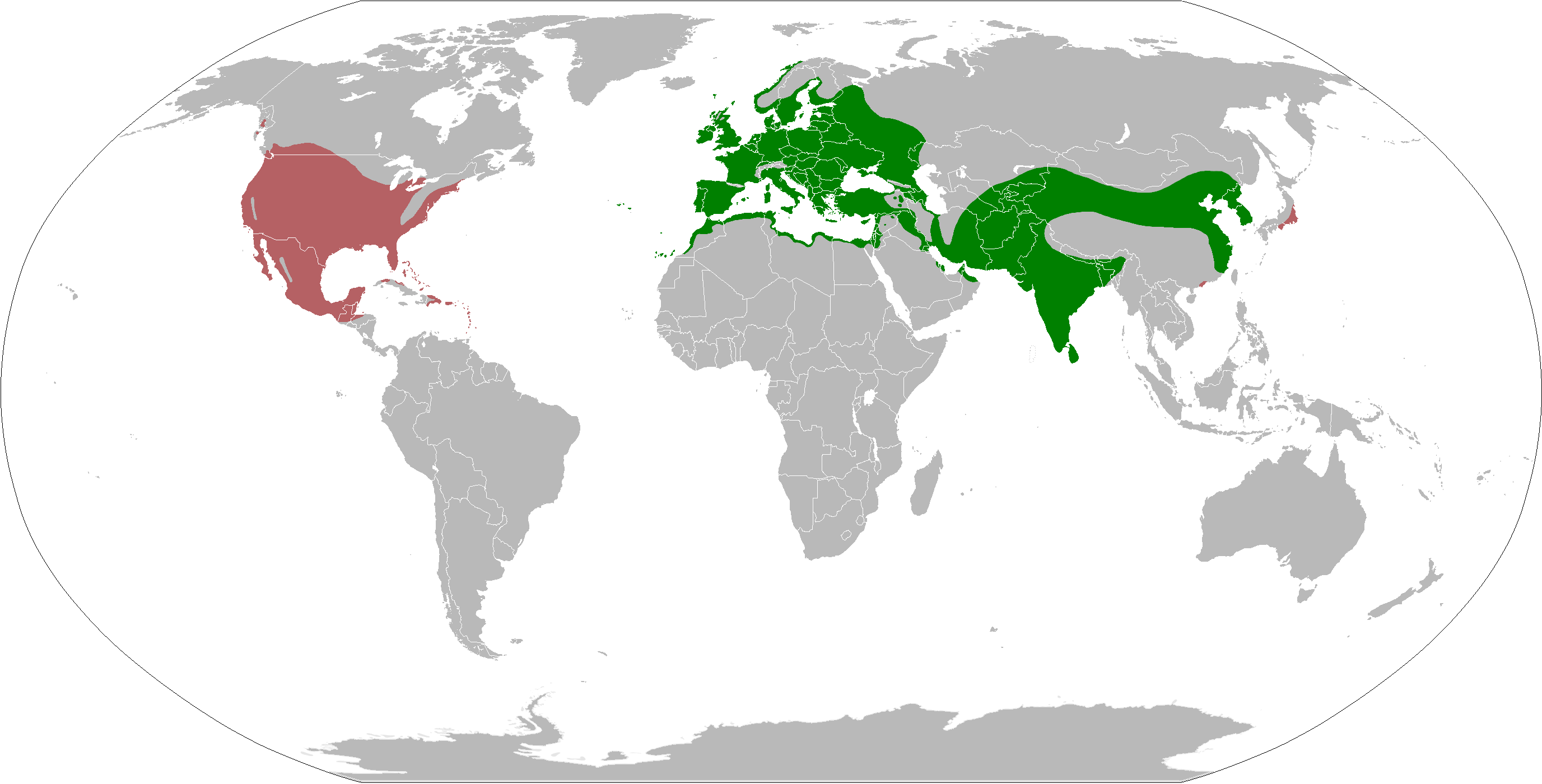
Español: Mapa de la distribución mundial de la Tórtola turca Streptopelia decaocto
English: Eurasian Collared Dove Streptopelia decaocto range map.
|
| दिनांक | |
| स्रोत | अपना कार्य according: Native range and North America introduction |
| लेखक | Osado |
लाइसेंस
मैं, इस कार्य का/की कॉपीराइट धारक, इसे निम्न लाइसेंस के अंतर्गत प्रकाशित करता/करती हूँ:
इस फ़ाइल को क्रिएटिव कॉमन्स श्रेय-समानसांझा 4.0 अंतर्राष्ट्रीय लाइसेंस के अंतर्गत लाइसेंस किया गया है।
- आप खुलकर:
- बाँट सकते हैं – रचना की प्रतिलिपि बना सकते हैं, बाँँट सकते हैं और संचारित कर सकते हैं
- रीमिक्स कर सकते हैं – कार्य को अनुकूलित कर सकते हैं
- निम्नलिखित शर्तों के अंतर्गत:
- श्रेय – यह अनिवार्य है कि आप यथोचित श्रेय प्रदान करें, लाइसेंस की कड़ी प्रदान करें, और अगर कोई बदलाव हुए हों तो उन्हें इंगित करें। आप ऐसा किसी भी उचित तरीके से कर सकते हैं, लेकिन किसी भी तरह उससे यह नहीं संकेत नहीं किया जाना चाहिए कि लाइसेंसधारी द्वारा आपको अथवा आपके इस प्रयोग का समर्थन किया जा रहा हो।
- समानसांझा – अगर आप इस रचना में कोई बदलाव करते हैं या इसपर आधारित कुछ रचित करते हैं तो आप अपने योगदान को सिर्फ इसी या इसके सामान किसी लाइसेंस के अंतर्गत बाँट सकते हैं।
चित्र का इतिहास
फ़ाइलका पुराना अवतरण देखने के लिये दिनांक/समय पर क्लिक करें।
| दिनांक/समय | थंबनेल | आकार | सदस्य | प्रतिक्रिया | |
|---|---|---|---|---|---|
| वर्तमान | 22:10, 20 नवम्बर 2021 | | 2,753 × 1,400 (128 KB) | MPF | Update European distribution per EBBA2 Atlas (2020), cleanup, rm now-split xanthocycla, use duller red for non-native |
| 13:45, 29 अप्रैल 2021 |  | 2,753 × 1,400 (160 KB) | MPF | Update European distribution per EBBA2 Atlas (2020), non-native from iNat records map; add ssp. xanthocycla | |
| 20:11, 21 मार्च 2018 |  | 2,753 × 1,400 (172 KB) | Maphobbyist | South Sudan border | |
| 15:10, 17 अप्रैल 2015 |  | 2,753 × 1,400 (148 KB) | Osado | Introduced range in North America according: http://bna.birds.cornell.edu/bna/species/630/articles/introduction | |
| 13:04, 16 अप्रैल 2015 |  | 2,753 × 1,400 (141 KB) | Osado | User created page with UploadWizard |
चित्र का उपयोग
निम्नलिखित पन्ने इस चित्र से जुडते हैं :
चित्र का वैश्विक उपयोग
इस चित्र का उपयोग इन दूसरे विकियों में किया जाता है:
- an.wikipedia.org पर उपयोग
- ar.wikipedia.org पर उपयोग
- arz.wikipedia.org पर उपयोग
- ast.wikipedia.org पर उपयोग
- be.wikipedia.org पर उपयोग
- bg.wikipedia.org पर उपयोग
- ceb.wikipedia.org पर उपयोग
- da.wikipedia.org पर उपयोग
- de.wikipedia.org पर उपयोग
- el.wikipedia.org पर उपयोग
- en.wikipedia.org पर उपयोग
- eo.wikipedia.org पर उपयोग
- es.wikipedia.org पर उपयोग
- eu.wikipedia.org पर उपयोग
- fi.wikipedia.org पर उपयोग
- fr.wikipedia.org पर उपयोग
- fy.wikipedia.org पर उपयोग
- ga.wikipedia.org पर उपयोग
- gl.wikipedia.org पर उपयोग
- he.wikipedia.org पर उपयोग
- hy.wikipedia.org पर उपयोग
- is.wikipedia.org पर उपयोग
- kk.wikipedia.org पर उपयोग
- ko.wikipedia.org पर उपयोग
- lv.wikipedia.org पर उपयोग
- ml.wikipedia.org पर उपयोग
- my.wikipedia.org पर उपयोग
- nl.wikipedia.org पर उपयोग
- nn.wikipedia.org पर उपयोग
- no.wikipedia.org पर उपयोग
- nv.wikipedia.org पर उपयोग
- pa.wikipedia.org पर उपयोग
- ru.wikipedia.org पर उपयोग
- sco.wikipedia.org पर उपयोग
- sd.wikipedia.org पर उपयोग
- sk.wikipedia.org पर उपयोग
- species.wikimedia.org पर उपयोग
- sr.wikipedia.org पर उपयोग
- sv.wikipedia.org पर उपयोग
- ta.wikipedia.org पर उपयोग
- tr.wikipedia.org पर उपयोग
- uk.wikipedia.org पर उपयोग
- ur.wikipedia.org पर उपयोग
- www.wikidata.org पर उपयोग
- zh.wikipedia.org पर उपयोग