चित्र:Typhoon Tip and Typhoon Sarah (1997).png
इस पूर्वावलोकन का आकार: 731 × 600 पिक्सेल। दूसरे रेसोल्यूशन्स: 293 × 240 पिक्सेल | 585 × 480 पिक्सेल | 773 × 634 पिक्सेल।
मूल चित्र ((773 × 634 पिक्सेल, फ़ाइल का आकार: 836 KB, MIME प्रकार: image/png))
|
|
यह फ़ाइल विकिमेडिया कॉमन्स से है। वहाँ पर इसका विवरण पृष्ठ निम्नोक्त है। कॉमन्स मुक्त लाइसेंसों के अंतर्गत उपलब्ध मीडिया फ़ाइलों का संग्रह है। आप भी इसमें मदद कर सकते हैं। |
.png)
| विवरण |
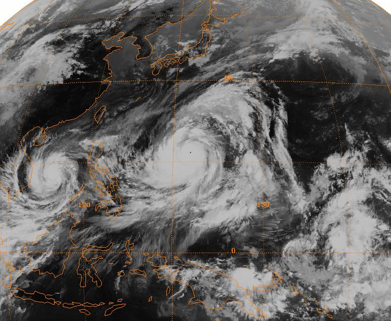
English: Full-disc satellite image of Typhoon Tip near its worldwide record peak intensity, located in the western Pacific Ocean. Typhoon Sarah is located to its west in the South China Sea. |
|||
| दिनांक | ||||
| स्रोत | http://www.ncdc.noaa.gov/gibbs/ | |||
| लेखक | GMS-1 Satellite | |||
| अनुमति (इस चित्र का पुनः उपयोग करना) |
|
चित्र का इतिहास
फ़ाइलका पुराना अवतरण देखने के लिये दिनांक/समय पर क्लिक करें।
| दिनांक/समय | थंबनेल | आकार | सदस्य | प्रतिक्रिया | |
|---|---|---|---|---|---|
| वर्तमान | 01:24, 29 दिसम्बर 2008 | | 773 × 634 (836 KB) | Hurricanehink | {{Information |Description={{en|1=Full-disc satellite image of Typhoon Tip near its worldwide record peak intensity, located in the western Pacific Ocean. Typhoon Sarah is located to its west in the South China Sea.}} |Source=http://www.ncdc.noaa.gov/gibb |
चित्र का उपयोग
निम्नलिखित पन्ने इस चित्र से जुडते हैं :
चित्र का वैश्विक उपयोग
इस चित्र का उपयोग इन दूसरे विकियों में किया जाता है:
- cs.wikipedia.org पर उपयोग
- en.wikipedia.org पर उपयोग
- ko.wikipedia.org पर उपयोग
- ru.wikipedia.org पर उपयोग
- simple.wikipedia.org पर उपयोग
- uk.wikipedia.org पर उपयोग
- vi.wikipedia.org पर उपयोग
- zh.wikipedia.org पर उपयोग
.png)