चित्र:World map of countries by ecological footprint (2007).svg

पूर्वावलोकन PNG का आकार SVG फ़ाइल: 800 × 353 पिक्सेल दूसरे रेसोल्यूशन्स: 320 × 141 पिक्सेल | 640 × 283 पिक्सेल | 1,024 × 452 पिक्सेल | 1,280 × 565 पिक्सेल | 2,560 × 1,130 पिक्सेल | 940 × 415 पिक्सेल।
मूल चित्र (SVG फ़ाइल, साधारणतः 940 × 415 पिक्सेल, फ़ाइल का आकार: 1.36 MB)
|
|
यह फ़ाइल विकिमेडिया कॉमन्स से है। वहाँ पर इसका विवरण पृष्ठ निम्नोक्त है। कॉमन्स मुक्त लाइसेंसों के अंतर्गत उपलब्ध मीडिया फ़ाइलों का संग्रह है। आप भी इसमें मदद कर सकते हैं। |
सारांश
| विवरण |
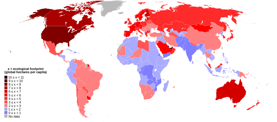
English: World map of countries shaded according to their ecological footprint in 2007 (published on 13 October 2010 by the Global Footprint Network). It is measured by the amount of global hectares that are affected by humans per capita of the country. Lighter shades denote countries with a lower ecological footprint per capita and darker shaded for countries with a higher ecological footprint per capita. The total ecological footprint (global hectares affected by humans) is measured as a total of six factors: cropland footprint, grazing footprint, forest footprint, fishing ground footprint, carbon footprint and built-up land.
Français : Mapemonde colorée selon l'empreinte écologique moyenne des habitants de chaque pays, exprimée en ha par personne, en 2007. Le tons plus chairs correspondent à une empreinte faible, les tons plus sombres à une empreinte plus forte. Six facteurs sont pris en compte pour mesurer cette empreinte: L'agriculture, le pâturage, l'exploitation forestière, la pêche, la production de carbone et l'urbanisation.
No data
0 ≤ x < 1
1 ≤ x < 2
2 ≤ x < 3
3 ≤ x < 4
4 ≤ x < 5
5 ≤ x < 6
6 ≤ x < 1
7 ≤ x < 8
8 ≤ x < 9
9 ≤ x < 10
10 ≤ x < 11 |
| दिनांक | |
| स्रोत | Self-made with data from list of countries by ecological footprint. |
| लेखक | Jolly Janner |
| दूसरे संस्करण |
|


.svg)
लाइसेंस
| मैं, इस कार्य का/की कॉपीराइट धारक, इस कार्य को सार्वजनिक डोमेन में प्रकाशित करता/करती हूँ। यह पूरे विश्व में लागू होता है। कुछ देशों में यह कानूनी तौर पर नहीं हो सकता है; ऐसा हो तो: मैं सभी को इस कार्य का इस्तेमाल किसी भी उद्देश्य से, बिना किसी बाधाओं के इन शर्तों के कानून द्वारा अनिवार्य किए तक करने की अनुमति देता/देती हूँ। |
चित्र का इतिहास
फ़ाइलका पुराना अवतरण देखने के लिये दिनांक/समय पर क्लिक करें।
| दिनांक/समय | थंबनेल | आकार | सदस्य | प्रतिक्रिया | |
|---|---|---|---|---|---|
| वर्तमान | 01:24, 30 मार्च 2018 | | 940 × 415 (1.36 MB) | Sisgeo | Employ a different color for countries under 2.1 gHa, the estimated limit of sustainability. |
| 18:44, 29 अक्टूबर 2010 |  | 940 × 415 (1.68 MB) | Jolly Janner | Added a white box to represent the background | |
| 18:38, 29 अक्टूबर 2010 |  | 940 × 415 (1.68 MB) | Jolly Janner | white background | |
| 18:36, 29 अक्टूबर 2010 |  | 940 × 415 (1.68 MB) | Jolly Janner | white background | |
| 18:24, 29 अक्टूबर 2010 |  | 940 × 415 (1.68 MB) | Jolly Janner | == {{int:filedesc}} == {{Information |Description={{en|1=World map of countries shaded according to their ecological footprint in 2007 (published on 13 October 2010 by the Global Footprint Network). It is measured by the amoun |
चित्र का उपयोग
निम्नलिखित पन्ने इस चित्र से जुडते हैं :
चित्र का वैश्विक उपयोग
इस चित्र का उपयोग इन दूसरे विकियों में किया जाता है:
- ca.wikipedia.org पर उपयोग
- el.wikipedia.org पर उपयोग
- en.wikipedia.org पर उपयोग
- en.wikibooks.org पर उपयोग
- eu.wikipedia.org पर उपयोग
- fa.wikipedia.org पर उपयोग
- fr.wikipedia.org पर उपयोग
- gl.wikipedia.org पर उपयोग
- it.wikipedia.org पर उपयोग
- ms.wikipedia.org पर उपयोग
- nl.wikipedia.org पर उपयोग
- pl.wikipedia.org पर उपयोग
- pl.wikibooks.org पर उपयोग
- ro.wikipedia.org पर उपयोग
- sk.wikipedia.org पर उपयोग
- sr.wikipedia.org पर उपयोग
- ta.wikipedia.org पर उपयोग
- uk.wikipedia.org पर उपयोग
- zh.wikipedia.org पर उपयोग
.svg)