चित्र:Yangtze River Map.png
इससे बड़ा रेसोल्यूशन उपलब्ध नहीं हैं।
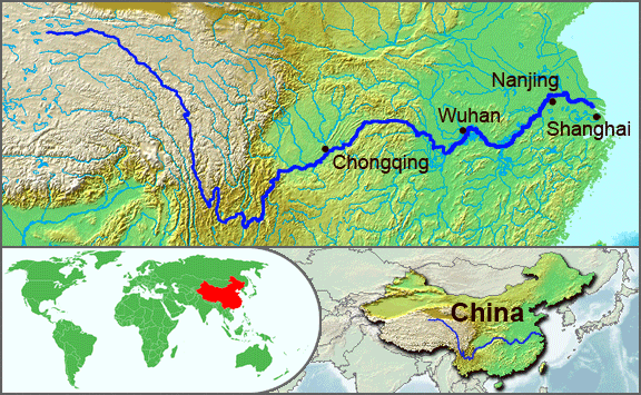
Yangtze_River_Map.png ((576 × 355 पिक्सेल, फ़ाइल का आकार: 123 KB, MIME प्रकार: image/png))
|
|
यह फ़ाइल विकिमेडिया कॉमन्स से है। वहाँ पर इसका विवरण पृष्ठ निम्नोक्त है। कॉमन्स मुक्त लाइसेंसों के अंतर्गत उपलब्ध मीडिया फ़ाइलों का संग्रह है। आप भी इसमें मदद कर सकते हैं। |
सारांश
| विवरण |
English: The underlying topographic maps used in this image come from the Demis Web Map Server, and are in the public domain. The world locator map is derived from :Image:BlankMap-World.png. I added the feature layers myself. —Papayoung ☯ 20:57, 1 October 2005 (UTC) |
| दिनांक | १ अक्टूबर २००५ (original upload date) |
| स्रोत | Transferred from en.wikipedia to Commons by Common Good using CommonsHelper. |
| लेखक | इसका मूल अपलोड करने वाला अंग्रेज़ी विकिपीडिया पर Papayoung है। |
| दूसरे संस्करण |
|
.JPG)
लाइसेंस
| इस फ़ाइल को क्रिएटिव कॉमन्स श्रेय-समानसांझा 3.0 अनरिपोर्टेड लाइसेंस के अंतर्गत लाइसेंस किया गया है। Subject to disclaimers. | ||
| ||
| This licensing tag was added to this file as part of the GFDL licensing update. |

|
इस दस्तावेज़ को Free Software Foundation द्वारा प्रकाशित GNU मुक्त प्रलेख लाइसेंस के संस्करण 1.2 या नए (बिना किसी अपरिवर्तनीय अनुभागों और अगले या पिछले आवरण के टेक्स्ट के) के अंतर्गत प्रतिलिपि बनाने, बाँटने और/या बदलने की अनुमति प्रदान की जाती है। इस लाइसेंस की एक प्रतिलिपि GNU मुक्त प्रलेख लाइसेंस नामक अनुभाग में शामिल है। Subject to disclaimers. |
मूल अपलोड लॉग
The original description page was here. All following user names refer to en.wikipedia.
- 2005-10-01 20:51 Papayoung 576×355× (125604 bytes) The underlying topographic maps used in this image come from the [http://www2.demis.nl/mapserver/mapper.asp Demis Web Map Server], and are in the public domain. The world locator map is derived from [[Commons:Image:BlankMap-World.png|BlankMap-World.png]].
- 2005-09-25 22:57 Papayoung 936×363× (221574 bytes) The underlying topographic maps used in this image come from the [http://www2.demis.nl/mapserver/mapper.asp Demis Web Map Server], and are in the public domain. I added the feature layers myself. —~~~~
चित्र का इतिहास
फ़ाइलका पुराना अवतरण देखने के लिये दिनांक/समय पर क्लिक करें।
| दिनांक/समय | थंबनेल | आकार | सदस्य | प्रतिक्रिया | |
|---|---|---|---|---|---|
| वर्तमान | 20:30, 7 मई 2009 | | 576 × 355 (123 KB) | File Upload Bot (Magnus Manske) | {{BotMoveToCommons|en.wikipedia|year={{subst:CURRENTYEAR}}|month={{subst:CURRENTMONTHNAME}}|day={{subst:CURRENTDAY}}}} {{Information |Description={{en|The underlying topographic maps used in this image come from the [http://www2.demis.nl/mapserver/mapper |
चित्र का उपयोग
निम्नलिखित पन्ने इस चित्र से जुडते हैं :
चित्र का वैश्विक उपयोग
इस चित्र का उपयोग इन दूसरे विकियों में किया जाता है:
- af.wikipedia.org पर उपयोग
- als.wikipedia.org पर उपयोग
- am.wikipedia.org पर उपयोग
- ary.wikipedia.org पर उपयोग
- ast.wikipedia.org पर उपयोग
- as.wikipedia.org पर उपयोग
- azb.wikipedia.org पर उपयोग
- be-tarask.wikipedia.org पर उपयोग
- bh.wikipedia.org पर उपयोग
- bn.wikipedia.org पर उपयोग
- bo.wikipedia.org पर उपयोग
- br.wikipedia.org पर उपयोग
- cs.wikipedia.org पर उपयोग
- de.wikipedia.org पर उपयोग
- en.wikipedia.org पर उपयोग
- en.wikinews.org पर उपयोग
- es.wikipedia.org पर उपयोग
- et.wikipedia.org पर उपयोग
- eu.wikipedia.org पर उपयोग
- fi.wikipedia.org पर उपयोग
- fo.wikipedia.org पर उपयोग
- frr.wikipedia.org पर उपयोग
- fr.wikipedia.org पर उपयोग
- fr.wikivoyage.org पर उपयोग
- fr.wiktionary.org पर उपयोग
- fy.wikipedia.org पर उपयोग
- hu.wikipedia.org पर उपयोग
- hy.wikipedia.org पर उपयोग
- hyw.wikipedia.org पर उपयोग
- id.wikipedia.org पर उपयोग
- ilo.wikipedia.org पर उपयोग
- incubator.wikimedia.org पर उपयोग
- io.wikipedia.org पर उपयोग
- it.wikipedia.org पर उपयोग
- ja.wikipedia.org पर उपयोग
- ka.wikipedia.org पर उपयोग
- ko.wikipedia.org पर उपयोग
- ku.wikipedia.org पर उपयोग
- la.wikipedia.org पर उपयोग
- lfn.wikipedia.org पर उपयोग
- lt.wikipedia.org पर उपयोग
इस चित्र के वैश्विक उपयोग की अधिक जानकारी देखें।