महाराणा प्रताप सागर
| यह सम्पूर्ण पृष्ठ या इसके कुछ अनुभाग हिन्दी के अतिरिक्त अन्य भाषा(ओं) में भी लिखे गए हैं। आप इनका करके विकिपीडिया की सहायता कर सकते हैं। |
हिमाचल प्रदेश के कांगड़ा जिले के शिवालिक पहाड़ियों के आर्द्र भूमि पर ब्यास नदी पर बाँध बनाकर एक जलाशय का निर्माण किया गया है जिसे महाराणा प्रताप सागर नाम दिया गया है। इसे पौंग जलाशय या पौंग बांध के नाम से भी जाना जाता है। यह बाँध 1975 में बनाया गया था। महाराणा प्रताप के सम्मान में नामित यह जलाशय या झील (1572–1597) एक प्रसिद्ध वन्यजीव अभयारण्य है और रामसर सम्मेलन द्वारा भारत में घोषित 85 अंतरराष्ट्रीय आर्द्रभूमि साइटों में से एक है।[1][2] जलाशय 24,529 हेक्टेयर (60,610 एकड़) के एक क्षेत्र तक फैला हुआ है,[3] और झीलों का भाग 15,662 हेक्टेयर (38,700 एकड़) है।

पौंग जलाशय और गोविन्दसागर जलाशय हिमाचल प्रदेश में हिमालय की तलहटी में दो सबसे महत्वपूर्ण मछली वाले जलाशय हैं।[3] इन जलाशयों में हिमालय राज्यों के भीतर मछली के प्रमुख स्रोत हैं।
स्थान
संपादित करेंपरियोजना के लिए निकटतम रेलवे स्टेशनों मुकेरियां, 30 किलोमीटर (18.6 मील) की दूरी पर, और पठानकोट, 58 किलोमीटर (19.9 मील) की दूरी पर। नगरोटा सुरियां और जवाली, जलाशय की परिधि पर स्थित है, जोकि एक संकीर्ण गेज रेलवे लाइन से जुड़े हुए हैं, कांगड़ा रेलवे लाइन पर, जोकि पठानकोट से जोगिन्द्रनगर को जोड़ता है।
जलाशय हिमाचल प्रदेश और पंजाब के प्रमुख शहरों के लिए सड़कों के अच्छे नेटवर्क से जुड़ा हुआ है। [4][5]
मुख्य शहरों से दूरी
- चंडीगढ़ से दूरी - 250 किमी (155.3 मील)
- अमृतसर से दूरी - 110 किमी (68.4 मील)
- धर्मशाला से दूरी - 55 किमी (34.2 मील)
- कांगड़ा से दूरी - 50 किमी (31.1 मील)
चंडीगढ़ और अमृतसर के हवाई अड्डे जोकि एक दूसरे से दूर है के अलावा, जलाशय से सबसे पास पठानकोट और गग्गल हवाई है। महाराणा प्रताप झील से भरमार की दूरी 12 km है।
स्थलाकृति
संपादित करेंजलाशय बीहड़ धौलाधार पर्वत श्रृंखला, सिन्धु-गंगा के मैदान इलाकों के उत्तरी किनारे पर हिमालय की सबसे कम तलहटी, और पहाड़ी नदियों की घाटियों के काटने के माध्यम से घिरा है।[6]
| यह सम्पूर्ण पृष्ठ या इसके कुछ अनुभाग हिन्दी के अतिरिक्त अन्य भाषा(ओं) में भी लिखे गए हैं। आप इनका करके विकिपीडिया की सहायता कर सकते हैं। |
जल विज्ञान और इंजीनियरिंग विशेषताएं
संपादित करेंजल विज्ञान
संपादित करेंब्यास नदी, जिस पर पौंग बांध स्थित है, सिन्धु नदी की पांच प्रमुख नदियों में से एक है। नदी रोहतांग दर्रे के पास ब्यास कुंड से बहती, ऊपरी हिमालय में, और आम तौर पर उत्तर-दक्षिण दिशा में लार्गी तक बहती है, जहाँ पर यह समकोण में तेजी से बदल जाती है और पोंग बांध के ऊपर पश्चिमी दिशा में बहती है।नदी पौंग बांध के लिए स्रोत से लगभग 116 किलोमीटर (72 मील) की कुल लंबाई में बहती है।[7]
जलाशय नालियां 12,561 वर्ग किलोमीटर (4,850 वर्ग मील) के क्षेत्र को जलग्रहण करती है, जिसमें से स्थायी रूप से बर्फ जलग्रहण 780 वर्ग किलोमीटर है (301 वर्ग मील)। बर्फ और ग्लेशियर के पिघलने के अलावा, जुलाई और सितंबर के बीच मानसून वर्षा जलाशय में पानी की आपूर्ति का एक प्रमुख स्रोत है। गर्म और आर्द्र जलवायु के साथ, 40 डिग्री (104 °F) सेल्सियस के अधिकतम तापमान में, परियोजना क्षेत्र गर्म मौसम का अनुभव करता है। सर्दियों में काफी ठंड रहती है और ज्यादातर सूख रहे हैं। बांध बाढ़ के प्रवाह के लिए सोखने के रूप में कार्य करता है, और जलाशय विनियमन मानसून के मौसम के दौरान दिनचर्या बाढ़ से उच्च भूमि क्षेत्रों के आसपास की बाढ़ से बचाता है।[8] The reservoir stretch is 42 km long (26 mi) with a maximum width of 19 km (11.8 mi), and with a mean depth of 35.7 m (117 ft). While the surface water temperature varies between 22.2–25.1 °C (72.0–77.2 °F), the incoming river water has a temperature range of 6–26 °C (42.8–78.8 °F). (4,850 sq mi)
इंजीनियरिंग विशेषताएं
संपादित करेंसिंधु जल संधि के अनुसार (1960), भारत और पाकिस्तान के बीच, भारत के विभाजन के बाद में, कुछ शर्तों के साथ, सिंधु नदी प्रणाली के पानी वार नदी आबंटित किया गया। भारत को तीन पूर्वी नदियों के अनन्य उपयोग के लिए मिला (रावी, ब्यास और सतलुज) और पाकिस्तान को तीन पश्चिमी नदियों के अनन्य उपयोग के लिए मिला (सिंधु, झेलम और चिनाब)। इस संधि के बाद, भारत ने तीन नदियों के पानी का उपयोग करने के लिए एक मास्टर प्लान तैयार किया जो इसके हिस्से के लिए आया था। और भाखड़ा बांध का निर्माण सतलुज नदी के पार किया गया था। फिर, ब्यास नदी में दो चरणों में उपयोग किया गया था, और पौंग बांध दूसरे चरण के विकास के गठन के साथ उपयोग किया। रावी नदी भी रणजीत सागर बांध परियोजना या थीन बांध के माध्यम से विकसित किया गया है। जल आपूर्ति और जल विद्युत उत्पादन, सभी तीन नदी के घटनाक्रम प्रकृति से जुड़े सिंचाई में बहुउद्देशीय हैं।[7]

तलवाड़ा के मैदानी भाग में प्रवेश के रूप में ब्यास बांध ब्यास नदी पर बनाया गया है, यह आधुनिक भारत के एक अन्य मंदिर के रूप में भी कहलाता है। यह 435 फीट (132.6 मीटर) गहरी नींव से ऊपर ऊंचाई का एक पृथ्वी कोर बजरी खोल बांध है, और यह भारत में सबसे ऊँचा तटबंध बांध है।[citation needed] जलाशय या झील की 8570 मिलियन क्यूबिक मीटर (303 अरब घन फुट) की भंडारण क्षमता है। The designed maximum flood discharge of 437,000 cu ft/s (12,400 m3/s) is discharged through a gated chute spillway (pictured) located on the left abutment of the dam.[9]

बांध की पुष्टि की सत्तारूढ़ सुविधाओं के नीचे विस्तृत हैं:[10]
- बांध का शीर्ष - 436 मीटर (1,430 फुट)
- अधिकतम जलाशय स्तर - 433 मीटर (1421 फीट)
- मृत भंडारण स्तर - 384 मीटर (1,260 फुट)
- सकल भंडारण क्षमता: 8570000000 घन मीटर (6,950,000 एकड़ · फुट)
- भंडारण क्षमता: 7290000000 घन मीटर (5,910,000 एकड़ · फुट)
- जलाशय की लंबाई: 41.8 किलोमीटर (26.0 मील)
- अधिकतम जलाशय की गहराई: 97.84 मीटर (321.0 फीट)
पन बिजली संयंत्र नीचे की ओर स्थित है, स्पिलवे संरचना के दाहिने पक्ष पर, शुरू में 360 मेगावाट (480,000 एचपी) की स्थापित क्षमता के लिए योजना बनाई गई थी, साथ छह उत्पादन इकाइयों: 6x60 मेगावाट (80,000 एचपी)। इसे बाद में 6x66 मेगावाट (89,000 एचपी) में उन्नत किया गया था, 2012 तक 396 मेगावाट (531,000 एचपी) की क्षमता के कुल था।[11] जलाशय से पानी लाक पाइप के माध्यम से पावर हाउस में भेजा गया है, 5.025 मीटर (16.5 फुट) व्यास के प्रत्येक।[9]
Reservoir operation is a crucial aspect since both Bhakra Dam and Pong Dam Projects necessitate their operation in an 'integrated mann3er' to achieve optimal benefits of irrigation and power. Water stored in the reservoir during the summer and rainy season, after meeting with the irrigation requirements of the partner states, is released in a regulated manner during lean periods, in a fixed schedule of Filling Period–Depletion Period for both the reservoirs. The filling and depletion period for
- the Bhakra reservoir is from 21 May to 20 September and 21 September to 20 May, and
- for Pong Dam reservoir, from 21 June to 20 and 21 September to 20 June respectively.
A technical committee of the Bhakra Beas Management Board (BBMB) authorizes the monthly releases appropriately honouring the requirements projected by the partner states. The operation manuals titled "Designer's Criteria for the Operation, Maintenance and Observation" for the Bhakra, Pong & Pando reservoirs, duly updated as required, provide the guiding rules for the efficient integrated operation of the reservoirs.[7] The two reservoirs supply irrigation and drinking water to Punjab, Haryana, Rajasthan, Delhi and Chandigarh. Himachal Pradesh is also provided with drinking water supply.[12]
पानी की गुणवत्ता
संपादित करेंजलाशय के लिए दर्ज की गई पानी की गुणवत्ता के मानकों हैं:[3]
- सेक ची डिस्क पारदर्शिता 0.12–4.8 metres (0.4–15.7 ft); पीएच 7.0–8.4; सिलिकेट 3.0–5.0 mg/l; क्लोराइड 6.0–7.0 mg/l; total hardness 22–28 mg/l, gives total hardness range from 19 to 68 mg/l; कुल क्षारीयता 53–81 mg/l; विशिष्ट चालकता 173–190 µmhos.
वनस्पति और जीव
संपादित करेंरामसर साइट
संपादित करेंPong Dam Lake was declared a Ramsar Wetland site on account of its rich waterfowl diversity for conservation and sustainable use of the wetland. This recognition was based on a proposal formulated by the Himachal State Council for Science, Technology and Environment, Shimla submitted to the Ramsar Bureau, Switzerland through the Union Ministry of Environment and Forests of the Government of India.[13][14]
The large reservoir and its strategic location in the extreme north-west of the northern plains has attracted migratory birds from the plains of India and Central Asian countries and Siberia. More than 220 bird species of 54 families have been recorded. The two-day waterfowl census, which ended on 1st Feb 2015, recorded over 130,000 [15] birds in the Pong Dam Wetlands.[16] The interception of the migratory birds on their trans-Himalayan fly path, during each migration season, has enriched the biodiversity values of the reservoir.[8] The Pong reservoir and its catchment have the following rich flora and fauna.
वन वनस्पति
संपादित करेंThe reservoir peripheral land area has mixed perennial and deciduous pine forests on hills. Eucalyptus trees have also been grown in the area. The forest growth provides enough sustenance to the migratory birds. The tree species of the forest area are acacia, jamun, shisham, mango, mulberry, ficus, kachanar, amla and prunus. A variety of shrubs, grasses and climbers have also been reported.[17] The reservoir seasonal water-level variation between the maximum water level and the minimum draw-down level does not permit growth of much emergent vegetation, but some amount of submerged vegetation has been noticed.[18]
अंतर्देशीय जल का अध्ययन
संपादित करेंA wide variety of commercially viable fish, 27 species of 5 families, such as mahseer, catla, mirror carp, singhara (native) and others are recorded in the Pong Dam reservoir and its tributaries. Before the reservoir was built, catfishes, mirror carps and a few coarse fish were the dominant fish fauna in the Beas River. With the emergence of the reservoir, commercial fishing was encouraged as an important programme not only to provide employment to about 1500 fishermen but also to promote the eco-tourism potential.[19]
A planned operation of fish stocking was launched with first introduction of common carp in 1974 and Indian major carps or silver carp in 1976–77. This resulted in a shift in the catch structure of the reservoir, with carps accounting for 61.8% of the total landings in 1987–88. The present fish stocks in the reservoir, in the sequence of their abundance are: 1) rohu, Aorichthys seenghala, 2) Labeo calbasu (native), 3) Tor putitora (Himalayan mahseer), 4) Cirrhinus mrigala, 5) Wallago attu, 6) Cyprinus carpio, 7) Labeo dero, 8) Catla catla and 9) Channa sp.[3] The reservoir, unlike other reservoirs in the region, has shown a marked growth in catch of mahseer fish, recording 20% of the total catch during 1999-2000 with the average size of the fish ranging from 1.5–1.7 कि॰ग्राम (3.3–3.7 पौंड). This is attributed to the change in the Himachal Pradesh (HP) Fishing Rules, with an added clause which specifies the minimum catchable size for mahseer as 300–500 मि॰मी॰ (10–20 इंच) or approximately 1.2 कि॰ग्राम (2.6 पौंड). That rule is stated to give to each female mahseer to breed at least once before being caught.[20]
Mahseer angling in the Pong Dam reservoir is said to be the only one of its kind in the country.[18]
पक्षी अभयारण्य
संपादित करें.jpg)
The reservoir was declared as a bird sanctuary in 1983. A 5-किलोमीटर (3.1 मील) belt from the periphery of the lake has been declared as buffer zone for the management of the bird sanctuary. The national, as well as international, significance of the sanctuary is enhanced because of its waterfowl diversity, which was evidenced by the increase of water fowl species from 39 prior to the reservoir to 54 species at post-reservoir stage. The number of birds reported, particularly during the winter period of November to March, has steadily increased over the years. The recent records indicate a water fowl count of 130,000 in 2004 and 142,000 during 2005 migratory birds – a major increase from the average annual count of 18,887 for the period 1988–1995.[8][21] The main bird species reported are the barheaded geese, Anser indicus, northern lapwing, ruddy shelduck, northern pintail, common teal, spot-billed duck, Eurasian coot, red-necked grebe, black-headed gulls, plovers, black stork, terns, water-fowl and egrets.[8]

The avian habitats in the reservoir area are categorized under the following heads:[8]
- The receding shore–line form mudflats and mud spits from October onwards which provide organic matter, worms, insects and molluscs for wintering birds and plovers. Wagtails, sand larks and pipits also use the mudflats.
- The shallow water on the margins of the reservoir and the open deep water are used by dabbling ducks (Anatinae) and some long-legged waders
- In the sandy banks near the reservoir periphery with dry sand banks strewn with small boulders, with little or no vegetation, stone curlew and pratincoles feed here.
- Below the outfall of the dam, swamp habitats and water side vegetation are used by birds such as ducks, coot, warblers, babblers, munias, kingfishers and predators.
- In the reservoir draw down areas, which are also cultivated by local people during winter, bar-headed geese and ruddy shelduck feed.
Around five thousand tourists visit the bird sanctuary during the winter season, and most of them come to watch migratory birds for the first time. Efforts are being made to encourage eco-tourism to attract more tourists to the reservoir.[19]
जीवजंतु
संपादित करेंThe periphery above the water surface area of the reservoir has recorded fauna species such as barking deer, sambar, wild boars, leopards and oriental small-clawed otters.[22]
मंदिर एवं पर्यटन
संपादित करेंBathu Temple:- 7 km from Jawali, a tehsil of Kangra District, there stands a cluster of antique, unique, tall temples which remain dipped in water for eight months: but stand exposed to the human eye only during March to June.
पानी के खेल
संपादित करेंA regional water-sports centre has been established in the Pong Dam Reservoir, which offers focused activities such as canoeing, rowing, sailing, and water skiing, apart from swimming. Training programmes are organized in water safety and rescue measures with three-tier water-sports courses: the basic course, intermediate course, and advanced course. Modern infrastructure facilities have been created with a 75-bed hostel and a 10-suite rest house. It is said to be the only centre of its type in the country. To know more about the institute please visit the website of the institute: ABVIMAS website link[2]
संरक्षण के उपाय
संपादित करेंThe following protection measures have enabled preservation of the reservoir ecosystem.[18][21]
- Declaring the entire reservoir as a Wildlife Sanctuary in 1986 by the Himachal Pradesh government has mostly eliminated poaching. Nearly 40 village forest development committees are functioning to prevent poaching of birds, in addition to nine checkposts. Two mobile checkposts monitor suspicious activities in the sanctuary areas, in coordination with the established check posts. This vigilance programme has established Nagrota Surian, Guglara, Tairess, Jambal Bassi, Nandpur Bhatoli and Dehra as dwelling places for the migratory birds.
- To check siltation of the reservoir and to provide bird nesting places, plantation of the peripheral area of the lake has been undertaken in a large way.
- The Protected Area Management Plan envisages boundary protection, habitat improvement, tourism and regulation, roads and staff quarters and so forth.
- One of the islands in the reservoir has been named Ramsar (after the Ramsar Convention) and developed for nature conservation education, complete with a rest house and boating facility.
- Organised reservoir fishing with full support of the Department of Fisheries has provided opportunities to reservoir Oustee (project affected people due to submergence) families to take up fishing as a profession. As per the last report, more than 1,789 fishermen are engaged in fishing activities which generates secondary benefits to more than 1,000 families. A large number of fishermen cooperative societies are functioning in the reservoir.
गेलरी
संपादित करें-
 Chute Spillway
 -
 कलहंस
कलहंस -
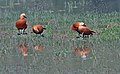 चकवा
चकवा -
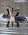 Red-necked grebe (Podiceps griseigena), recorded for the first time in India in 1987
 -
 सफ़ेद बगुला
 -
 किंगफिशर
 -
 Muntjac deer, also known as barking deer
 -
 Oriental small clawed otter


-_Female_at_Bharatpur_I.jpg)


.jpg)


सन्दर्भ
संपादित करें- ↑ "Salient Features of some prominent wetlands of India", pib.nic.in, Release ID 29706, web: nic6 Archived 2016-03-04 at the वेबैक मशीन.
- ↑ अ आ "Pong Dam Lake Ramsar Sanctuary Travel Guide" Archived 2015-06-29 at the वेबैक मशीन, World66.com.
- ↑ अ आ इ ई "Coldwater Fish and Fisheries in the Indian Himalayas, Lakes And Reservoirs" Archived 2015-09-24 at the वेबैक मशीन, H.S. Raina and T. Petr, FAO.org, 1998. सन्दर्भ त्रुटि:
<ref>अमान्य टैग है; "cold" नाम कई बार विभिन्न सामग्रियों में परिभाषित हो चुका है - ↑ "संग्रहीत प्रति". मूल से 20 अप्रैल 2012 को पुरालेखित. अभिगमन तिथि 14 अक्तूबर 2015.
- ↑ http://bbmb.gov.in/english/pong_tourism.asp Archived 2007-07-07 at the वेबैक मशीन Pong Dam
- ↑ "hptdc.gov.in". मूल से 15 मार्च 2019 को पुरालेखित. अभिगमन तिथि 15 जून 2020.
- ↑ अ आ इ "Bhakra Left & Right Bank Power Houses Bhakra Dam" (PDF). मूल (PDF) से 10 अगस्त 2011 को पुरालेखित. अभिगमन तिथि 14 अक्तूबर 2015.
- ↑ अ आ इ ई उ "Information Sheet on Ramsar Wetlands (RIS)" (PDF). मूल (PDF) से 8 अक्तूबर 2012 को पुरालेखित. अभिगमन तिथि 14 अक्तूबर 2015.
- ↑ अ आ "Photo gallery page BBMB". मूल से 1 अक्तूबर 2011 को पुरालेखित. अभिगमन तिथि 14 अक्तूबर 2015. सन्दर्भ त्रुटि:
<ref>अमान्य टैग है; "photo" नाम कई बार विभिन्न सामग्रियों में परिभाषित हो चुका है - ↑ http://cwc.nic.in/main/webpages/projects.html Archived 2015-09-23 at the वेबैक मशीन.
- ↑ "संग्रहीत प्रति". मूल से 28 फ़रवरी 2011 को पुरालेखित. अभिगमन तिथि 14 अक्तूबर 2015.
- ↑ http://bhakra.nic.in/english/eaudit.pdf Archived 2016-03-03 at the वेबैक मशीन Environmental Audit Report – BBMB Beas Project (Beas Unit – II)
- ↑ "World Wetland Day" (PDF). मूल (PDF) से 11 फ़रवरी 2012 को पुरालेखित. अभिगमन तिथि 14 अक्तूबर 2015.
- ↑ "Pong Dam lake gets Ramsar site status" Archived 2015-07-10 at the वेबैक मशीन, Tribuneindia.com, 2003.
- ↑ "Over 130,000 Birds Recorded". मूल से 25 सितंबर 2015 को पुरालेखित. अभिगमन तिथि 14 अक्तूबर 2015.
- ↑ "Ramsar Sites Database", web: RS6[मृत कड़ियाँ], 2002.
- ↑ Pongdam Lake Archived 2008-12-21 at the वेबैक मशीन, 123himachal.com.
- ↑ अ आ इ "Pong Dam Lake". मूल से 16 फ़रवरी 2010 को पुरालेखित. अभिगमन तिथि 14 अक्तूबर 2015.
- ↑ अ आ "संग्रहीत प्रति". मूल से 21 दिसंबर 2008 को पुरालेखित. अभिगमन तिथि 14 अक्तूबर 2015. सन्दर्भ त्रुटि:
<ref>अमान्य टैग है; "fish" नाम कई बार विभिन्न सामग्रियों में परिभाषित हो चुका है - ↑ Fisheries Growth Archived 2008-12-12 at the वेबैक मशीन, himachal.gov.in.
- ↑ अ आ "birds/1118/tourism/places/myhimachal-news Pong abuzz with migratory birds dam". मूल से 3 मार्च 2016 को पुरालेखित. अभिगमन तिथि 14 अक्तूबर 2015.
- ↑ "Himachal Tourism". मूल से 15 जनवरी 2007 को पुरालेखित. अभिगमन तिथि 14 अक्तूबर 2015.